
30 Dec 2010
Alternative Routes To MOA Or Mall Of Asia From Quezon City
It seems that going to Mall Of Asia from north of Metro Manila via EDSA is the best way to take. It's just one continues direction without any turns. Without even changing road. But take note that there are times that this main thoroughfare is heavily congested. Bumper to bumper traffic suddenly appears making your travel a bit of annoying. Alternative routes and directions is very helpful at all times. So here are other options to take in going to Mall Of Asia as well as the Cultural Center of the Philippines Complex if you really need to take the car with you. Try to drive along these routes to get yourself familiar with them.
You can take Quezon Avenue all the way to Quiapo via Espana. Then continue driving up to Lawton, crossing Pasig River via Quezon Bridge. Do not use this route every Friday. Stay to the middle of the road and continue driving. For your information, Quezon Boulevard does't end in Quiapo. It's still Quezon Boulevard you're driving along in front of Manila Post Office in Lawton. The road name only changed the moment it bends to the left. It becomes Padre Burgos Street and it runs parallel to the wall of Intramuros up to Roxas Boulevard. At this point you're on Padre Burgos Street even without changing the road that you're taking. Only name of the road has changed. Upon approach of the first stop light on Padre Burgos, change lane from middle to the right to avoid getting onto the Lagusnilad underpass, which will take you to Taft, and that's wrong way. You must get to Roxas Boulevard. So after crossing the stop light, you must take the road to the right of Lagusnilad underpass. Okay here's another information. That road with stop light intersecting Padre Burgos, its name is Victoria to your right, going to an entrance of Intramuros that is nearer to Mapua Institute of Technology, Lyceum of the Philippines, Manila High School and Manila Bulletin. To your left is Conception Street, the side where Manila City Hall is located. Next to Manila City Hall is SM City Manila. You can get to Manila City Hall or SM City Manila from that route by first turning right onto Victoria and then make a U-Turn back toward Padre Burgos and cross Padre Burgos to get to opposite street of Concepcion. From Concepcion Street, you have the options to get to Manila City Hall or SM City Manila.
Now back to our route to MOA or Mall Of Asia via Cultural Center of the Philippines Complex. As I've mentioned, you must stay to the right of Padre Burgos after crossing Victoria Street to avoid getting onto Lagusnilad underpass. Once you passed that junction, stay to the middle of Padre Burgos Street. As you'll notice Padre Burgos bends to the right at this point. And then there's the second stop light. That road that runs perpendicurlly to the left of Padre Burgos is Finance Road. After that road is the third stop light of Padre Burgos, and that intersection is General Luna Street, the route and direction to Intramuros Entrance nearer to Pamantasan Ng Maynila or PLM, Department of Labor, San Agustin Church, Knight of Columbus, Casa Manila Patio, Father Blanco's Garden and Manila Cathedral. The moment you enter Intramuros, General Luna Street will take you to San Agustin Church and Manila Cathedral. Also, right before you enter Intramuros via General Luna Street is the area they called Round Table - a landmark that now never exist I think.
After General Luna Street, the fourth stop light is Palacio Street. You need to stay to the left of Padre Burgos Street after crossing Palacio Street in preparation for turning left on Roxas Boulevard. You're now traversing along the edge of Luneta or Rizal Park. If you're going to Manila Ocean Park and Quirino Grandstand, stay to the middle of Padre Burgos and cross Roxas Boulevard. After crossing Roxas Boulevard, the road becomes Katigbak Drive and Quirino Grandstand will be visible after Katigbak Drive turn left. Manila Ocean Park is at the back of Quirino Grandstand. You can park your car in front of Quirino Grandstand.
Back to topic. Turn left on Roxas Boulevard from Padre Burgos Street and stay to the middle. Drive all the way, cross intersections of U.N. Avenue, Padre Faura, Pedro Gil and Quirino Avenue. After crossing Quirino Avenue, stay to the right in preparation for turning right onto Cultural Center of the Philippines Complex.
After Quirino Avenue to your right is the Manila Yatch Club followed by Philippine Navy Headquarters and then the Cultural Center of the Philippines or CCP Complex. Turn right onto the next street after the Philippine Navy Headquarters. That street is Pedro Bukaneg. It's opposite street to the left is Pablo Ocampo Street. From Bukaneg Street, turn left on Magdalena Jalandoni and drive all the way crossing Vicente Sotto Street where the Star City is located to the left and Gil Puyat Avenue where the World Trade Center is located. Note: There are times Magdalena Jalandoni is closed from Bukaneg. If that's the case, go straight on Padre Bukaneg then turn left on the next corner. This is where Tanghalang Francisco Balagtas or Folk Arts Theater is located, the building you see in front of you before you turn left. Turn left on Vicente Sotto toward Magdalena Jalandoni and turn right onto Jalandoni. Philippine International Convention Center or PICC is along Vicente Sotto, visible from this direction.
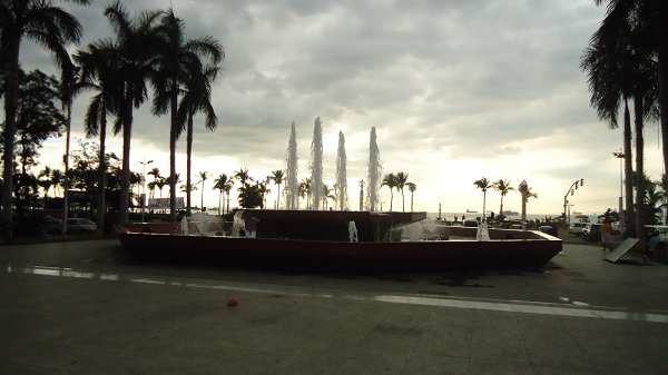
After crossing Gil Puyat Avenue intersection, road name changed to President Diosdado Macapagal Boulevard. Upon approaching the first stop light on Macapagal Boulevard, stay to the right of Macapagal and turn right onto Seaside Boulevard. Stay to the middle of Seaside Boulevard all the way until you see the Mall Of Asia. You will cross the intersection of Diokno Boulevard. After you cross Diokno Boulevard, to your right is the One Esplanade located at the corner of Diokno Boulevard and Seaside Boulevard. You can park at the open parking which is visible a little while after the road bends to the left and where Club LAX is located. How to get to Club LAX MOA? Park your car in the open parking space in the esplanade of MOA using the first Parking Entrance after you pass One Esplanade. LAX is just a few meters from the first entrance of open parking you get to see along Seaside Boulevard from One Esplanade. Now, if you're destination is MOA itself and you don't want to walk that far, get to the covered parking located at the North Building and another one at the South Building. Just pass by the first entrance of open parking from which LAX is located and from Seaside Boulevard turn left on Sunset Avenue, and you'll easily see the entrance to the covered parking up ahead next to SM Hypermart. You're now in Mall Of Asia or MOA. Enjoy!
To be continued
Read more...
You can take Quezon Avenue all the way to Quiapo via Espana. Then continue driving up to Lawton, crossing Pasig River via Quezon Bridge. Do not use this route every Friday. Stay to the middle of the road and continue driving. For your information, Quezon Boulevard does't end in Quiapo. It's still Quezon Boulevard you're driving along in front of Manila Post Office in Lawton. The road name only changed the moment it bends to the left. It becomes Padre Burgos Street and it runs parallel to the wall of Intramuros up to Roxas Boulevard. At this point you're on Padre Burgos Street even without changing the road that you're taking. Only name of the road has changed. Upon approach of the first stop light on Padre Burgos, change lane from middle to the right to avoid getting onto the Lagusnilad underpass, which will take you to Taft, and that's wrong way. You must get to Roxas Boulevard. So after crossing the stop light, you must take the road to the right of Lagusnilad underpass. Okay here's another information. That road with stop light intersecting Padre Burgos, its name is Victoria to your right, going to an entrance of Intramuros that is nearer to Mapua Institute of Technology, Lyceum of the Philippines, Manila High School and Manila Bulletin. To your left is Conception Street, the side where Manila City Hall is located. Next to Manila City Hall is SM City Manila. You can get to Manila City Hall or SM City Manila from that route by first turning right onto Victoria and then make a U-Turn back toward Padre Burgos and cross Padre Burgos to get to opposite street of Concepcion. From Concepcion Street, you have the options to get to Manila City Hall or SM City Manila.
Now back to our route to MOA or Mall Of Asia via Cultural Center of the Philippines Complex. As I've mentioned, you must stay to the right of Padre Burgos after crossing Victoria Street to avoid getting onto Lagusnilad underpass. Once you passed that junction, stay to the middle of Padre Burgos Street. As you'll notice Padre Burgos bends to the right at this point. And then there's the second stop light. That road that runs perpendicurlly to the left of Padre Burgos is Finance Road. After that road is the third stop light of Padre Burgos, and that intersection is General Luna Street, the route and direction to Intramuros Entrance nearer to Pamantasan Ng Maynila or PLM, Department of Labor, San Agustin Church, Knight of Columbus, Casa Manila Patio, Father Blanco's Garden and Manila Cathedral. The moment you enter Intramuros, General Luna Street will take you to San Agustin Church and Manila Cathedral. Also, right before you enter Intramuros via General Luna Street is the area they called Round Table - a landmark that now never exist I think.
After General Luna Street, the fourth stop light is Palacio Street. You need to stay to the left of Padre Burgos Street after crossing Palacio Street in preparation for turning left on Roxas Boulevard. You're now traversing along the edge of Luneta or Rizal Park. If you're going to Manila Ocean Park and Quirino Grandstand, stay to the middle of Padre Burgos and cross Roxas Boulevard. After crossing Roxas Boulevard, the road becomes Katigbak Drive and Quirino Grandstand will be visible after Katigbak Drive turn left. Manila Ocean Park is at the back of Quirino Grandstand. You can park your car in front of Quirino Grandstand.
Back to topic. Turn left on Roxas Boulevard from Padre Burgos Street and stay to the middle. Drive all the way, cross intersections of U.N. Avenue, Padre Faura, Pedro Gil and Quirino Avenue. After crossing Quirino Avenue, stay to the right in preparation for turning right onto Cultural Center of the Philippines Complex.
After Quirino Avenue to your right is the Manila Yatch Club followed by Philippine Navy Headquarters and then the Cultural Center of the Philippines or CCP Complex. Turn right onto the next street after the Philippine Navy Headquarters. That street is Pedro Bukaneg. It's opposite street to the left is Pablo Ocampo Street. From Bukaneg Street, turn left on Magdalena Jalandoni and drive all the way crossing Vicente Sotto Street where the Star City is located to the left and Gil Puyat Avenue where the World Trade Center is located. Note: There are times Magdalena Jalandoni is closed from Bukaneg. If that's the case, go straight on Padre Bukaneg then turn left on the next corner. This is where Tanghalang Francisco Balagtas or Folk Arts Theater is located, the building you see in front of you before you turn left. Turn left on Vicente Sotto toward Magdalena Jalandoni and turn right onto Jalandoni. Philippine International Convention Center or PICC is along Vicente Sotto, visible from this direction.
After crossing Gil Puyat Avenue intersection, road name changed to President Diosdado Macapagal Boulevard. Upon approaching the first stop light on Macapagal Boulevard, stay to the right of Macapagal and turn right onto Seaside Boulevard. Stay to the middle of Seaside Boulevard all the way until you see the Mall Of Asia. You will cross the intersection of Diokno Boulevard. After you cross Diokno Boulevard, to your right is the One Esplanade located at the corner of Diokno Boulevard and Seaside Boulevard. You can park at the open parking which is visible a little while after the road bends to the left and where Club LAX is located. How to get to Club LAX MOA? Park your car in the open parking space in the esplanade of MOA using the first Parking Entrance after you pass One Esplanade. LAX is just a few meters from the first entrance of open parking you get to see along Seaside Boulevard from One Esplanade. Now, if you're destination is MOA itself and you don't want to walk that far, get to the covered parking located at the North Building and another one at the South Building. Just pass by the first entrance of open parking from which LAX is located and from Seaside Boulevard turn left on Sunset Avenue, and you'll easily see the entrance to the covered parking up ahead next to SM Hypermart. You're now in Mall Of Asia or MOA. Enjoy!
To be continued
LRT-1 Tayuman Station Destinations
Tayuman Station of LRT-1 or the yellow lane serves commuters from district of Tondo as well as Santa Cruz Manila. Main destination here is the SM San Lazaro, a branch of SM Shopping Malls, where you can watch movies after shopping and then eat on fast food chains and restaurants. Along Tayuman Street near to SM San Lazaro is a nice and affordable traveler's hotel. There's a church and student dormitories. Arsenio Lacson Avenue starts perpendicularly from Tayuman near SM City San Lazaro. Lacson Avenue is the main thoroughfare that is connected to Nagtahan Flyover, the main linkage to the SLEX and the first entrance ramp of Manila Skyway.

Here are the destinations in going to Tayuman Station of LRT-1:
Read more...
Here are the destinations in going to Tayuman Station of LRT-1:
- Esperito Santo Parochial Church
- SM City San Lazaro
- Starbucks
- Land Transportation Office (LTO) Tayuman
- Tayuman Hotel
- Jeepney ride to Pritil Puregold
- Family Clinic Colleges
- Tayuman Commercial Center
- La Suerte Garments Manufacturing
29 Dec 2010
How To Get To Blue Wave Macapagal
March 12, 2016 Update: This directional guide to Blue Wave Macapagal is now obsolete. Blue Wave Macapagal was demolished and the spot which given directional guide here is now being developed as cluster of condominiums.
Blue Wave Macapagal is located at the corner of President Diosdado Macapagal Boulevard and EDSA Extension in Pasay City. Commuting by bus from Monumento and Quezon City, there's only one route and direction going to Blue Wave - EDSA. This post will also tell you directions to Blue Wave Macapagal from other parts of Metro Manila.

From Caloocan City
Ride bus with Baclaran MOA sign at the corner of Rizal Avenue and 5th Avenue or at Monumento. Get off at Diosdado Macapagal Boulevard.
From Valenzuela, Navotas and Malabon
You need to get to EDSA anywhere in Caloocan, then ride bus with Baclaran MOA sign. Get off at Macapagal Blvd. If there are busses that ply directly from your area going to Baclaran like in Letre and Marulas, then ride right there.
From Novaliches
Ride bus with Baclaran MOA sign along Quirino Highway and get off at Macapagal Boulevard.
From Fairview
Ride bus with Baclaran MOA sign and get off at Macapagal Blvd.
How to get to Blue Wave Macapagal from South of Metro Manila - Alabang, Muntinlupa, Pacita, etc.
From Alabang by bus
Ride bus going to Monumento, Novaliches or Fairview. Get off at unloading station in EDSA e.g. Magallanes MRT Station or Ayala MRT Station. Cross EDSA via MRT station's overpass - there are elevators in some MRT stations. Ride another bus with Baclaran MOA sign. Get off at Macapagal Blvd.
From Alabang by jeepney
There are terminals of jeepneys going to Pasay Rotonda located in Alabang near Metropolis Star Mall. Some of them just pick up passengers along East Service Road near corner Montillano Street. Ride jeepney with Pasay Rotonda sign. Get off at Pasay Rotonda. Some jeepney drivers drop off passengers right at the MRT Taft Station. Some of them drop off passengers after crossing Taft Avenue. You can either ride just below the elevated MRT Station or near Save More Supermarket after crossing Taft. Plenty of jeepneys going to MOA pass by along EDSA. You don't need to go to the terminal of the so called orange passenger shuttle service going to MOA. It's too far, along Taft, out of the way. Just ride any jeepney or even bus with MOA sign along EDSA. Get off at Macapagal Blvd.
From Bacoor, Zapote, Las Pinas, Cavite and other areas near Alabang-Zapote Road and Emilio Aguinaldo Highway Junction
Ride a bus going to Lawton, Sta. Cruz, or Buendia. This busses take the route of Coastal Road also known as Manila-Cavite Expressway or Aguinaldo Blvd. Lawton and Sta. Cruz bound busses cross EDSA intersection via the flyover. So you must get off right before or after the bus get onto the flyover. Always tell the conductor or driver to drop you off on the unloading station. Most of the time, they don't stop after stopping on the last unloading before EDSA. In this case, it's safe to get off at Baclaran. There's a terminal of jeepneys going to MOA near Lydia's Restaurant along the service road of Roxas Blvd before Redemptorist Church. Ride right there and get off at Macapagal Boulevard. If any chance you get to EDSA, then ride a bus or jeepney with MOA sign and get off at Macapagal Blvd.
From Quiapo, Espana, Sta. Cruz, Dapitan and Binondo
Ride jeepney going to Baclaran and get off at EDSA. Ride another jeepney or bus going to MOA and get off at Macapagal Blvd.
Top
How to get to Blue Wave Macapagal by MRT and LRT?
From any station of MRT-3, get off at Taft Avenue Station.
From any station of LRT-1, get off at EDSA Station.
From any station of LRT-2, get off at Araneta Center-Cubao Station. Walk your way to MRT-3 Cubao Station. LRT-2 and MRT-3 are linked by walkway inside Gateway Mall going to Farmers Plaza Mall where the MRT-3 is connected. Ride a southbound MRT train or train going to Taft Avenue Station. Get off right there at Taft Station.
Under the elevated MRT Taft Station, ride a jeepney going to MOA or Mall of Asia. Jeepneys stop right before the MRT Station so you might walk a little bit backward. If at any case, you find it hard to get a ride there, you might go across Taft Avenue and ride a jeepney going to MOA along EDSA just in front of Save More Supermarket.
Get off at Pres. Diosdado Macapagal Boulevard.
Top
How to get to Blue Wave Macapagal by car?
Route #1
If you're coming from North of Metro Manila e.g. Caloocan, Malabon, Valenzuela, Navotas, Bulacan, Novaliches, Fairview, Cubao and other parts of Quezon City take EDSA. Drive all the way to Pasay until you cross Roxas Boulevard under the flyover. After crossing Roxas Boulevard, stay to the right of EDSA and turn right onto Macapagal Boulevard and make a U-Turn on the first U-Turn slot along Macapagal to get to the Blue Wave. You can easily see the entrance to the parking from the distance. Alternately, you can cross Macapagal Boulevard then get to the parking entrance along EDSA.
Route #2
From south of Metro Manila and the province of Cavite. Take Coastal Road or Manila-Cavite Expressway and drive all the way to NAIA Road where Coastal Road ends. NAIA Road is where Coastal Mall is situated to the left corner. NAIA Road is a main intersection with traffic lights. Upon approaching NAIA Road, change lane to the left and turn left on NAIA Road then turn right onto Diosdado Macapagal Boulevard. Stay to the middle and drive all the way until you cross EDSA. After crossing EDSA stay to the right and make a U-Turn to get to the Blue Wave Macapagal.
Route #3
Coming from areas of Sucat, NAIA-3, NAIA-1, Multinational Village and neighboring vicinity take Sucat Road, Imelda Avenue and Ninoy Aquino Avenue. Turn left on NAIA Road and stay on the middle. Cross Roxas Blvd and turn right onto Diosdado Macapagal Blvd. Stay to the middle and drive all the way until you cross EDSA. After crossing EDSA stay to the right and make a U-Turn to get to the Blue Wave Macapagal.
Route #4
From Alabang take the Skyway and exit on Magallanes Exit then turn left on EDSA. Stay on the middle of EDSA and drive all the way until you cross Roxas Boulevard under the flyover. After crossing Roxas Boulevard, stay to the right of EDSA and turn right onto Macapagal Boulevard and make a U-Turn on the first U-Turn slot along Macapagal to get to the Blue Wave. You can easily see the entrance to the parking from the distance. Alternately, you can cross Macapagal Boulevard then get to the parking entrance along EDSA.
Route #5
From Bulacan, Pampanga and North Luzon, take the route to CCP Complex. Search "how to get to ccp complex" in our search box on the sidebar. From Pedro Bukaneg in CCP Complex turn left on Magdalena Jalandoni and stay to the middle, cross Gil Puyat Avenue Extension. After crossing Gil Puyat Avenue intersection, road name becomes President Diosdado Macapagal Boulevard. Stay to the middle of Macapagal Boulevard, cross the Seaside Boulevard. Next stop light is on EDSA intersection. Before reaching EDSA stay to the right and the Blue Wave is located before the EDSA-Macapagal Boulevard intersection.
Route #6
From Quezon City, take the route to CCP Complex. Search "how to get to ccp complex" in our search box on the sidebar. From Pedro Bukaneg in CCP Complex turn left on Magdalena Jalandoni and stay to the middle, cross Gil Puyat Avenue Extension. After crossing Gil Puyat Avenue intersection, road name becomes President Diosdado Macapagal Boulevard. Stay to the middle of Macapagal Boulevard, cross the Seaside Boulevard. Next stop light is on EDSA intersection. Before reaching EDSA stay to the right and the Blue Wave is located before the EDSA-Macapagal Boulevard intersection.
Top
Location Map of Blue Wave Macapagal
Top
Read more...
Blue Wave Macapagal is located at the corner of President Diosdado Macapagal Boulevard and EDSA Extension in Pasay City. Commuting by bus from Monumento and Quezon City, there's only one route and direction going to Blue Wave - EDSA. This post will also tell you directions to Blue Wave Macapagal from other parts of Metro Manila.

| BY BUS & JEEP | BY LRT & MRT | BY CAR | LOCATION MAP |
| How to get to Blue Wave Macapagal from North of Metro Manila - Caloocan, Malabon, Navotas, Valenzuela, Fairview, Novaliches and other parts of Quezon City | How to get to Blue Wave Macapagal from South of Metro Manila - Alabang, Muntinlupa, Pacita, etc. From Las Pinas, Cavite and nearby areas From Quiapo, Espana, Sta. Cruz, Dapitan, Binondo |
From Caloocan City
Ride bus with Baclaran MOA sign at the corner of Rizal Avenue and 5th Avenue or at Monumento. Get off at Diosdado Macapagal Boulevard.
From Valenzuela, Navotas and Malabon
You need to get to EDSA anywhere in Caloocan, then ride bus with Baclaran MOA sign. Get off at Macapagal Blvd. If there are busses that ply directly from your area going to Baclaran like in Letre and Marulas, then ride right there.
From Novaliches
Ride bus with Baclaran MOA sign along Quirino Highway and get off at Macapagal Boulevard.
From Fairview
Ride bus with Baclaran MOA sign and get off at Macapagal Blvd.
How to get to Blue Wave Macapagal from South of Metro Manila - Alabang, Muntinlupa, Pacita, etc.
From Alabang by bus
Ride bus going to Monumento, Novaliches or Fairview. Get off at unloading station in EDSA e.g. Magallanes MRT Station or Ayala MRT Station. Cross EDSA via MRT station's overpass - there are elevators in some MRT stations. Ride another bus with Baclaran MOA sign. Get off at Macapagal Blvd.
From Alabang by jeepney
There are terminals of jeepneys going to Pasay Rotonda located in Alabang near Metropolis Star Mall. Some of them just pick up passengers along East Service Road near corner Montillano Street. Ride jeepney with Pasay Rotonda sign. Get off at Pasay Rotonda. Some jeepney drivers drop off passengers right at the MRT Taft Station. Some of them drop off passengers after crossing Taft Avenue. You can either ride just below the elevated MRT Station or near Save More Supermarket after crossing Taft. Plenty of jeepneys going to MOA pass by along EDSA. You don't need to go to the terminal of the so called orange passenger shuttle service going to MOA. It's too far, along Taft, out of the way. Just ride any jeepney or even bus with MOA sign along EDSA. Get off at Macapagal Blvd.
From Bacoor, Zapote, Las Pinas, Cavite and other areas near Alabang-Zapote Road and Emilio Aguinaldo Highway Junction
Ride a bus going to Lawton, Sta. Cruz, or Buendia. This busses take the route of Coastal Road also known as Manila-Cavite Expressway or Aguinaldo Blvd. Lawton and Sta. Cruz bound busses cross EDSA intersection via the flyover. So you must get off right before or after the bus get onto the flyover. Always tell the conductor or driver to drop you off on the unloading station. Most of the time, they don't stop after stopping on the last unloading before EDSA. In this case, it's safe to get off at Baclaran. There's a terminal of jeepneys going to MOA near Lydia's Restaurant along the service road of Roxas Blvd before Redemptorist Church. Ride right there and get off at Macapagal Boulevard. If any chance you get to EDSA, then ride a bus or jeepney with MOA sign and get off at Macapagal Blvd.
From Quiapo, Espana, Sta. Cruz, Dapitan and Binondo
Ride jeepney going to Baclaran and get off at EDSA. Ride another jeepney or bus going to MOA and get off at Macapagal Blvd.
Top
How to get to Blue Wave Macapagal by MRT and LRT?
From any station of MRT-3, get off at Taft Avenue Station.
From any station of LRT-1, get off at EDSA Station.
From any station of LRT-2, get off at Araneta Center-Cubao Station. Walk your way to MRT-3 Cubao Station. LRT-2 and MRT-3 are linked by walkway inside Gateway Mall going to Farmers Plaza Mall where the MRT-3 is connected. Ride a southbound MRT train or train going to Taft Avenue Station. Get off right there at Taft Station.
Under the elevated MRT Taft Station, ride a jeepney going to MOA or Mall of Asia. Jeepneys stop right before the MRT Station so you might walk a little bit backward. If at any case, you find it hard to get a ride there, you might go across Taft Avenue and ride a jeepney going to MOA along EDSA just in front of Save More Supermarket.
Get off at Pres. Diosdado Macapagal Boulevard.
Top
How to get to Blue Wave Macapagal by car?
Route #1
If you're coming from North of Metro Manila e.g. Caloocan, Malabon, Valenzuela, Navotas, Bulacan, Novaliches, Fairview, Cubao and other parts of Quezon City take EDSA. Drive all the way to Pasay until you cross Roxas Boulevard under the flyover. After crossing Roxas Boulevard, stay to the right of EDSA and turn right onto Macapagal Boulevard and make a U-Turn on the first U-Turn slot along Macapagal to get to the Blue Wave. You can easily see the entrance to the parking from the distance. Alternately, you can cross Macapagal Boulevard then get to the parking entrance along EDSA.
Route #2
From south of Metro Manila and the province of Cavite. Take Coastal Road or Manila-Cavite Expressway and drive all the way to NAIA Road where Coastal Road ends. NAIA Road is where Coastal Mall is situated to the left corner. NAIA Road is a main intersection with traffic lights. Upon approaching NAIA Road, change lane to the left and turn left on NAIA Road then turn right onto Diosdado Macapagal Boulevard. Stay to the middle and drive all the way until you cross EDSA. After crossing EDSA stay to the right and make a U-Turn to get to the Blue Wave Macapagal.
Route #3
Coming from areas of Sucat, NAIA-3, NAIA-1, Multinational Village and neighboring vicinity take Sucat Road, Imelda Avenue and Ninoy Aquino Avenue. Turn left on NAIA Road and stay on the middle. Cross Roxas Blvd and turn right onto Diosdado Macapagal Blvd. Stay to the middle and drive all the way until you cross EDSA. After crossing EDSA stay to the right and make a U-Turn to get to the Blue Wave Macapagal.
Route #4
From Alabang take the Skyway and exit on Magallanes Exit then turn left on EDSA. Stay on the middle of EDSA and drive all the way until you cross Roxas Boulevard under the flyover. After crossing Roxas Boulevard, stay to the right of EDSA and turn right onto Macapagal Boulevard and make a U-Turn on the first U-Turn slot along Macapagal to get to the Blue Wave. You can easily see the entrance to the parking from the distance. Alternately, you can cross Macapagal Boulevard then get to the parking entrance along EDSA.
Route #5
From Bulacan, Pampanga and North Luzon, take the route to CCP Complex. Search "how to get to ccp complex" in our search box on the sidebar. From Pedro Bukaneg in CCP Complex turn left on Magdalena Jalandoni and stay to the middle, cross Gil Puyat Avenue Extension. After crossing Gil Puyat Avenue intersection, road name becomes President Diosdado Macapagal Boulevard. Stay to the middle of Macapagal Boulevard, cross the Seaside Boulevard. Next stop light is on EDSA intersection. Before reaching EDSA stay to the right and the Blue Wave is located before the EDSA-Macapagal Boulevard intersection.
Route #6
From Quezon City, take the route to CCP Complex. Search "how to get to ccp complex" in our search box on the sidebar. From Pedro Bukaneg in CCP Complex turn left on Magdalena Jalandoni and stay to the middle, cross Gil Puyat Avenue Extension. After crossing Gil Puyat Avenue intersection, road name becomes President Diosdado Macapagal Boulevard. Stay to the middle of Macapagal Boulevard, cross the Seaside Boulevard. Next stop light is on EDSA intersection. Before reaching EDSA stay to the right and the Blue Wave is located before the EDSA-Macapagal Boulevard intersection.
Top
Location Map of Blue Wave Macapagal
Top
28 Dec 2010
Roxas Boulevard: Great Place To Watch Fireworks On New Year Eve

Roxas Boulevard is a long stretch of thouroughfare by the Manila Bay, about 9 kilometers, from Anda Circle in the Port Area up to NAIA Road in Paranaque. It was so beautiful according to those who born ahead of us. But that was 40 years ago, when the whole stretch of the so called "lover's boulevard", known then as Dewey Boulevard, ran smoothly without obstructions brought about by major development that slowly engulfed our metropolis after the war. Then, it was so lovely. With coconut trees dotting along its line, Roxas Boulevard was the real picture of a grandeur highway. Today, Roxas Boulevard is wider. To give way for progress some coconut trees must be cut down. And so we have now CCP Complex, Mall of Asia, Metropolitan Park, Asiaworld City and soon the Nayong Pilipino Entertainment City. Well, if it's not yet stalled as presumed.
Manila Bay at Roxas Boulevard now confined to Malate and Ermita Districts. And if you're wondering what part of Roxas Boulevard is the best area to watch fireworks this coming New Year's Eve, no doubt it's the part from Pedro Gil up to Quirino Avenue. Yearly, the local government of the city of Manila allots big budget for pyrotechnics to make the welcoming of the coming new year more memorable, joyful and festive. So if you're thinking of where to spend your New Year to watch fireworks on the very first hour of 2011, consider this great destination.
Here are the directions to Roxas Boulevard by Manila Bay from different parts of Metro Manila
| BY CAR | BY LRT/MRT | BY JEEPNEY | LOCATION MAP |
Route #1
From south of Metro Manila and the province of Cavite. Take Coastal Road and drive all the way until you cross NAIA Road. By this time you're already driving along Roxas Boulevard. Stay to the middle and drive all the way until you reach Ermita District. You'll cross EDSA and Gil Puyat Avenue via flyovers. Two stop lights, P. Ocampo formerly Vito Cruz and Quirino Avenue, after that your already in the Manila Bay where the fireworks display in Manila will take place. Now, you must think of how to park your car properly. You can make a U-Turn on Pedro Gil but it's not legal. The best way is to drive all the way to T.M. Kalaw, stay to the left and turn left on Kalaw going to Quirino Grandstand. Make a U-Turn there then turn right onto Roxas Boulevard again. Now, you're driving on south bound lane of Roxas Boulevard. You can easily see parking areas along Roxas Boulevard after you pass U.S. Embassy and there's another one right before the intersection of Quirino Avenue.
Route #2
From north of Metro Manila and provinces of Bulacan, Pampanga and North Luzon, take A. Bonifacio Avenue and Dimasalang Street to Quezon Avenue. On Quezon Avenue go straight up to Quiapo and Lawton. Road name change to Padre Burgos after passing Lawton area. Stay to the right of P. Burgos Street to avoid getting to Taft Avenue. Stay on P. Burgos and turn left on Roxas Blvd. Stay to the middle and cross intersections of T.M. Kalaw, U.N. Avenue and Padre Faura. After passing the U.S. Embassy stay to the left of Roxas Boulevard. You can easily see parking areas along Roxas Boulevard after you pass U.S. Embassy and there's another one right before the intersection of Quirino Avenue.
Route #3
From Alabang take the Skyway and exit on Gil Puyat. Avoid getting to the Gil Puyat Avenue flyover. Turn left on Gil Puyat Avenue and drive all the way. Cross Taft Avenue under LRT-1 and turn right onto Roxas Boulevard. Two stop lights, P. Ocampo formerly Vito Cruz and Quirino Avenue, after that your already in the Manila Bay where the fireworks display in Manila will take place. Now, you must think of how to park your car properly. You can make a U-Turn on Pedro Gil but it's not legal. The best way is to drive all the way to T.M. Kalaw, stay to the left and turn left on Kalaw going to Quirino Grandstand. Make a U-Turn there then turn right onto Roxas Boulevard again. Now, you're driving on south bound lane of Roxas Boulevard. You can easily see parking areas along Roxas Boulevard after you pass U.S. Embassy and there's another one right before the intersection of Quirino Avenue.
Route #4
Coming from areas of Sucat, NAIA-3, NAIA-1, Multinational Village and neighboring vicinity take Sucat Road, Imelda Avenue and Ninoy Aquino Avenue. Turn left on NAIA Road then turn right onto Roxas Boulevard. Stay to the middle and drive all the way until you reach Ermita District. You'll cross EDSA and Gil Puyat Avenue via flyovers. Two stop lights, P. Ocampo formerly Vito Cruz and Quirino Avenue, after that your already in the Manila Bay where the fireworks display in Manila will take place. Now, you must think of how to park your car properly. You can make a U-Turn on Pedro Gil but it's not legal. The best way is to drive all the way to T.M. Kalaw, stay to the left and turn left on Kalaw going to Quirino Grandstand. Make a U-Turn there then turn right onto Roxas Boulevard again. Now, you're driving on south bound lane of Roxas Boulevard. You can easily see parking areas along Roxas Boulevard after you pass U.S. Embassy and there's another one right before the intersection of Quirino Avenue.
Route #5
From Caloocan, Navotas, Malabon take Jose Abad Santos Avenue. Jose Abad Santos Avenue ends up in Recto. Cross Recto Avenue and Reina Regente begins. Drive on Reina Regente up to Plaza Lorenzo Ruiz. Turn right to go with the flow of one way traffic around Plaza Lorenzo Ruiz turning left on Juan Luna Street. Stay on Juan Luna crossing Dasmarinas Street. Follow where public jeepneys turn. Turn left on the next street after Dasmarinas. Turn right onto Jones bridge. You are now taking Padre Burgos Street. Stay to the right of P. Burgos Street to avoid getting to Taft Avenue. Stay on P. Burgos and turn left on Roxas Blvd. Stay to the middle and cross intersections of T.M. Kalaw, U.N. Avenue and Padre Faura. After passing the U.S. Embassy stay to the left of Roxas Boulevard. You can easily see parking areas along Roxas Boulevard after you pass U.S. Embassy and there's another one right before the intersection of Quirino Avenue.
Route #6
From Pasig, Sta. Mesa and neighboring vicinity take Ramon Magsasay Blvd and Legarda Street crossing Nagtahan by taking flyover to Legarda. On Legarda Street, just cross Recto Avenue. Legarda ends up in Arlegui but the road continues under the name of P. Casal Street. Drive on P. Casal and cross Pasig River via Ayala Bridge. You are now in Ayala Blvd. Go straight crossing Taft Avenue passing under LRT-1. You are now in Finance Road. Turn left on Padre Burgos Street. Another stop light and you must stay to the left of P. Burgos Street. Turn left on Roxas Blvd. Stay to the middle and cross intersections of T.M. Kalaw, U.N. Avenue and Padre Faura. After passing the U.S. Embassy stay to the left of Roxas Boulevard. You can easily see parking areas along Roxas Boulevard after you pass U.S. Embassy and there's another one right before the intersection of Quirino Avenue.
Top
How to get to Manila Bay at Roxas Boulevard by MRT and LRT?
Route #1
LRT-1 from north stations namely Roosevelt, Balintawak, Monumento and other stations. Get off at Carriedo Station then ride jeepney infront of Santa Cruz Church bound to "Baclaran Mabini" or "Vito Cruz Mabini". You can get to Santa Cruz Church by walking to the west side of Carriedo Street between Plaza Fair and Philtrust Bank, then turn right on the next corner. The church is up ahead. Make sure the jeepney you're going to ride bear sign that read "Mabini" Ask driver to kindly drop you off at Rajah Sulayman. You can now walk your way to Roxas Boulevard.
Route #2
LRT-1 from South Terminal of Baclaran and all other stations from there. Get off at Libertad Station. Walk to the Philtrust Bank and wait for jeepney bound to Pier or Horizon. Ride and then if you ride a Pier bound jeep, get off at San Andres and walk toward Roxas Boulevard. If you ride Horizon bound jeep, take another jeepney via "Mabini" and get off at San Andres. You can also get off at Gil Puyat Avenue Station, ride a jeepney with "Evengelista" sign, get off at Horizon Street and take another jeep with "Manini" on its sign. Get off at San Andres Street, then walk toward Roxas Boulevard.
Route #3
LRT-2 Stations, all stations. From your station get off at Recto then walk your way to Avenida Street. Ride jeepney with "Baclaran Mabini" or "Vito Cruz Mabini" sign. There must be the "Mabini" on the jeepney sign or you will not get there. Ask driver to kindly drop you off at Rajah Sulayman. Walk your way to Roxas Boulevard.
Route #4
MRT-3, all Stations. From your station, get off at Taft Station then take another train ride North bound or Monumento bound on LRT-1. LRT and MRT are interconnected. Get off at Libertad Station. Walk to the Philtrust Bank and wait for jeepney bound to Pier or Harrison. Ride and then if you ride a Pier bound jeep, get off at San Andres and walk toward Roxas Boulevard. If you ride Harrison bound jeep, take another jeepney via "Mabini" and get off at San Andres. You can also get off at Gil Puyat Avenue Station, ride a jeepney with "Evengelista" sign, get off at Horizon Street and take another jeep with "Manini" on its sign. Get off at San Andres Street, then walk toward Roxas Boulevard.
Top
How to get to Manila Bay at Roxas Boulevard by jeepney?
All jeepneys that ply the route of "Monumento-Baclaran" vice versa via Mabini pass by Rajah Sulayman Park. From Rajah Sulayman Park, walk your way to Roxas Boulevard and see where's the best place for you to watch the fireworks. There are also Baclaran bound jeepneys that ply the route of Mabini. Always make sure that there's the "Mabini" word on the sign of jeepney you are going to ride.
All you need to do is to ride another jeep bound to Baclaran via Mabini. If you're from Pasig, ride Baclaran bound jeepney in Quiapo. If you're from Cubao, there's also Baclaran bound jeepney there via Mabini. If there's none then ride one in Quiapo. Same way if you're from Fairview or Novaliches and Quezon Avenue. If you're from Monumento, then just get off right in front of Malate Church. Rajah Sulayman is opposite the church. From Makati, ride bus then get off at Harrison Street then ride a jeep bound to Monumento or Quiapo via Mabini. Wherever you might be coming from, just remember to ride a jeepney with "Mabini" on its sign.
Top
Location Map of Manila Bay at Roxas Boulevard
Top
27 Dec 2010
Rajah Sulayman Park: Where Is It And How To Get There?
Rajah Sulayman Park is a plaza along Roxas Boulevard in front of Malate Church. It is named in honor of the last King of Manila, Rajah Sulayman. A monument named also after him is erected at the center of the park alongside a beautiful fountain. It's one of the few destinations of Filipino families who are in budget during New Year's Eve to watch fireworks on Manila Bay.
Here are directions from different parts of Metro Manila to Rajah Sulayman Park:
| BY CAR | BY LRT/MRT | BY JEEPNEY | LOCATION MAP |
Route #1
From south of Metro Manila and the province of Cavite. Take Coastal Road, stay on the middle, and drive all the way. Coastal Road ends up in NAIA Road. Roxas Boulevard begins right after you cross NAIA Road. Maintain your car on the middle and just stay on Roxas Boulevard. You will cross Airport Road then get onto the flyover of EDSA and another flyover crossing the intersection of Gil Puyat Avenue. You shall cross two more intersections with stop lights before you turn onto Rajah Sulayman Park. These intersections are Pablo Ocampo formerly Vito Cruz located infront of CCP Complex and Quirino Avenue after the Central Bank of the Philippines Complex. After crossing Quirino Avenue, you must stay to the right of the road and when you see Aristocrat Restaurant, turn right onto the street next to it. Rajah Sulayman Park is right there opposite the north side of the Aristocrat Restaurant.
Route #2
Coming from areas of Sucat, NAIA-3, NAIA-1, Multinational Village and neighboring vicinity take Sucat Road, Imelda Avenue and Ninoy Aquino Avenue. Turn left on NAIA Road and stay on the middle. After crossing the two intersections of Airport Road and Quirino Avenue, you must stay to the right of NAIA Road and turn right onto Roxas Boulevard. Avoid getting onto the service road of Roxas Boulevard. Make sure you're on the main road of Roxas Boulevard. Maintain your car on the middle and just stay on Roxas Boulevard. You will cross Airport Road then get onto the flyover of EDSA and another flyover crossing the intersection of Gil Puyat Avenue. You shall cross two more intersections with stop lights before you turn onto Rajah Sulayman Park. These intersections are Pablo Ocampo formerly Vito Cruz located infront of CCP Complex and Quirino Avenue after the Central Bank of the Philippines Complex. After crossing Quirino Avenue, you must stay to the right of the road and when you see Aristocrat Restaurant, turn right onto the street next to it. Rajah Sulayman Park is right there opposite the north side of the Aristocrat Restaurant. There are lot's of parking area around the plaza but you must make sure to arrive early so that there are still available slots for you.
Route #3
From Alabang take the Skyway and exit on Gil Puyat. Avoid getting to the Gil Puyat Avenue flyover. Turn left on Gil Puyat Avenue and drive all the way. Cross Taft Avenue under LRT-1 and after crossing Leveriza Street and Harrison Street, you must stay to the right of Gil Puyat Avenue. Turn right onto Roxas Boulevard. Avoid getting onto the service road of Roxas Boulevard. Make sure you're on the main road of Roxas Boulevard. Stay to the middle of Roxas Boulevard. You shall cross two more intersections with stop lights before you turn onto Rajah Sulayman Park. These intersections are Pablo Ocampo formerly Vito Cruz located infront of CCP Complex and Quirino Avenue after the Central Bank of the Philippines Complex. After crossing Quirino Avenue, you must stay to the right of the road and when you see Aristocrat Restaurant, turn right onto the street next to it. Rajah Sulayman Park is right there opposite the north side of the Aristocrat Restaurant. There are lot's of parking area around the plaza but you must make sure to arrive early so that there are still available slots for you.
Route #4
From Bulacan, Pampanga and North Luzon, take A. Bonifacio Avenue and Dimasalang Street to Quezon Avenue. On Quezon Avenue go straight up to Quiapo and Lawton. Road name change to Padre Burgos after passing Lawton area. Stay to the right of P. Burgos Street to avoid getting to Taft Avenue. Stay on P. Burgos and turn left on Roxas Blvd. Stay to the middle of Roxas Blvd. After crossing stop light of Padre Faura, you must stay to the left of Roxas Boulevard and turn left on the next intersection of Pedro Gil Street. Right after you turn left from Roxas Boulevard onto Pedro Gil Street, you must immediately turn right onto the service road running parallel to Roxas Boulevard. Stay on the middle of Roxas Boulevard. You will pass by Diamond Hotel and after the junction is the Magsaysay Building. Go on and up ahead you will see Max Restaurant. Next to Max Restaurant is the Rajah Sulayman Park. There are lot's of parking area around the plaza but you must make sure to arrive early so that there are still available slots for you.
Route #5
From Caloocan, Navotas, Malabon take Jose Abad Santos Avenue. Jose Abad Santos Avenue ends up in Recto. Cross Recto Avenue and Reina Regente begins. Drive on Reina Regente up to Plaza Lorenzo Ruiz. Turn right to go with the flow of one way traffic around Plaza Lorenzo Ruiz turning left on Juan Luna Street. Stay on Juan Luna crossing Dasmarinas Street. Follow where public jeepneys turn. Turn left on the next street after Dasmarinas. Turn right onto Jones bridge. You are now taking Padre Burgos Street. Stay to the right of P. Burgos Street to avoid getting to Taft Avenue. Stay on P. Burgos and turn left on Roxas Blvd. Stay to the middle of Roxas Blvd. After crossing stop light of Padre Faura, you must stay to the left of Roxas Boulevard and turn left on the next intersection of Pedro Gil Street. Right after you turn left from Roxas Boulevard onto Pedro Gil Street, you must immediately turn right onto the service road running parallel to Roxas Boulevard. Stay on the middle of Roxas Boulevard. You will pass by Diamond Hotel and after the junction is the Magsaysay Building. Go on and up ahead you will see Max Restaurant. Next to Max Restaurant is the Rajah Sulayman Park. There are lot's of parking area around the plaza but you must make sure to arrive early so that there are still available slots for you.
Route #6
From Quezon City take Quezon Avenue all the way to Espana then take Lerma onto Quiapo and Lawton. After Lawton, the road you are taking bends and it becomes Padre Burgos Street. Stay to the right of P. Burgos Street to avoid getting to Taft Avenue. Stay on P. Burgos after the stop light on area of Manila City Hall. Padre Burgos bends to the right. After two stop lights stay to the left of P. Burgos and turn left on Roxas Blvd. Stay to the middle of Roxas Blvd. After crossing stop light of Padre Faura, you must stay to the left of Roxas Boulevard and turn left on the next intersection of Pedro Gil Street. Right after you turn left from Roxas Boulevard onto Pedro Gil Street, you must immediately turn right onto the service road running parallel to Roxas Boulevard. Stay on the middle of Roxas Boulevard. You will pass by Diamond Hotel and after the junction is the Magsaysay Building. Go on and up ahead you will see Max Restaurant. Next to Max Restaurant is the Rajah Sulayman Park. There are lot's of parking area around the plaza but you must make sure to arrive early so that there are still available slots for you.
Route #7
From Makati take Ayala and Gil Puyat Avenue. Drive all the way on the middle of Gil Puyat Avenue. Cross Taft Avenue under LRT-1 and after crossing Leveriza Street and Horizon Street, you must stay to the right of Gil Puyat Avenue. Turn right onto Roxas Boulevard. Avoid getting onto the service road of Roxas Boulevard. Make sure you're on the main road of Roxas Boulevard. Stay to the middle of Roxas Boulevard. You shall cross two more intersections with stop lights before you turn onto Rajah Sulayman Park. These intersections are Pablo Ocampo formerly Vito Cruz located infront of CCP Complex and Quirino Avenue after the Central Bank of the Philippines Complex. After crossing Quirino Avenue, you must stay to the right of the road and when you see Aristocrat Restaurant, turn right onto the street next to it. Rajah Sulayman Park is right there opposite the north side of the Aristocrat Restaurant. There are lot's of parking area around the plaza but you must make sure to arrive early so that there are still available slots for you.
Route #8
From Pasig, Sta. Mesa and neighboring vicinity take Ramon Magsasay Blvd and Legarda Street crossing Nagtahan by taking flyover to Legarda. On Legarda Street, just cross Recto Avenue. Legarda ends up in Arlegui but the road continues under the name of P. Casal Street. Drive on P. Casal and cross Pasig River via Ayala Bridge. You are now in Ayala Blvd. Go straight crossing Taft Avenue passing under LRT-1. You are now in Finance Road. Turn left on Padre Burgos Street. Another stop light and you must stay to the left of P. Burgos Street. Turn left on Roxas Blvd. Stay to the middle of Roxas Blvd. After crossing stop light of Padre Faura, you must stay to the left of Roxas Boulevard and turn left on the next intersection of Pedro Gil Street. Right after you turn left from Roxas Boulevard onto Pedro Gil Street, you must immediately turn right onto the service road running parallel to Roxas Boulevard. Stay on the middle of Roxas Boulevard. You will pass by Diamond Hotel and after the junction is the Magsaysay Building. Go on and up ahead you will see Max Restaurant. Next to Max Restaurant is the Rajah Sulayman Park. There are lot's of parking area around the plaza but you must make sure to arrive early so that there are still available slots for you.
Top
How to get to Rajah Sulayman by MRT or LRT?
Route #1
LRT-1 from north stations namely Roosevelt, Balintawak, Monumento and other stations. Get off at Carriedo Station then ride jeepney infront of Santa Cruz Church bound to "Baclaran Mabini" or "Vito Cruz Mabini". You can get to Santa Cruz Church by walking to the west side of Carriedo Street between Plaza Fair and Philtrust Bank, then turn right on the next corner. The church is up ahead. Make sure the jeepney you're going to ride bear sign that read "Mabini" Ask driver to kindly drop you off at Rajah Sulayman Park which is right there near the loading and unloading zone of passenger jeepneys.
Route #2
LRT-1 from South Terminal of Baclaran and all other stations from there. Get off at Libertad Station. Walk to the Philtrust Bank and wait for jeepney bound to Pier or Horizon. Ride and then if you ride a Pier bound jeep, get off at San Andres and walk toward Roxas Boulevard. If you ride Horizon bound jeep, take another jeepney via "Mabini" and get off at San Andres. You can also get off at Gil Puyat Avenue Station, ride a jeepney with "Evengelista" sign, get off at Horizon Street and take another jeep with "Manini" on its sign. Get off at San Andres Street, then walk toward Roxas Boulevard to get to Rajah Sulayman.
Route #3
LRT-2 Stations, all stations. From your station get off at Recto then walk your way to Avenida Street. Ride jeepney with "Baclaran Mabini" or "Vito Cruz Mabini" sign. There must be the "Mabini" on the jeepney sign or you will not get there. Ask driver to kindly drop you off at Rajah Sulayman Park which is right there near the loading and unloading zone of passenger jeepneys.
Route #4
MRT-3, all Stations. From your station, get off at Taft Station then take another train ride North bound or Monumento bound on LRT-1. LRT and MRT are interconnected. Get off at Libertad Station. Walk to the Philtrust Bank and wait for jeepney bound to Pier or Horizon. Ride and then if you ride a Pier bound jeep, get off at San Andres and walk toward Roxas Boulevard. If you ride Horizon bound jeep, take another jeepney via "Mabini" and get off at San Andres. You can also get off at Gil Puyat Avenue Station, ride a jeepney with "Evengelista" sign, get off at Horizon Street and take another jeep with "Manini" on its sign. Get off at San Andres Street, then walk toward Roxas Boulevard to get to Rajah Sulayman.
Top
How to get to Rajah Sulayman by jeepney?
All jeepneys that ply the route of "Monumento-Baclaran" vice versa via Mabini pass by Rajah Sulayman Park. There are also Baclaran bound jeepneys that ply the route of Mabini. Always make sure that there's the "Mabini" word on the sign of jeepney you are going to ride.
All you need to do is to ride another jeep bound to Baclaran via Mabini. If you're from Pasig, ride Baclaran bound jeepney in Quiapo. If you're from Cubao, there's also Baclaran bound jeepney there via Mabini. If there's none then ride one in Quiapo. Same way if you're from Fairview or Novaliches and Quezon Avenue. If you're from Monumento, then just get off right in front of Malate Church. Rajah Sulayman is opposite the church. From Makati, ride bus then get off at Horizon Street then ride a jeep bound to Monumento or Quiapo via Mabini. Wherever you might be coming from, just remember to ride a jeepney with "Mabini" on its sign.
Top
Location Map of Rajah Sulayman
Top
Where To Go To Watch Fireworks on New Year's Eve In Budget
Wondering where to take your family to watch fireworks display during New Year's Eve Celebration this year? Want to be somewhere safe but still in the middle of the celebration and don't want to miss the spectacles of firecrackers and pyrotechnics? To make sure you and your family won't miss the welcoming of 2011 in the tradition of festive mode and with the big bang, get down to one of these recommended places for New Year's Eve Celebration on December 31, 2010. Plan your trip so that you can set up as early as possible for the full view of the New Year's Eve Fireworks Spectacle.
Happy New Year to all!!!
Read more...
- Manila Bay at Roxas Boulevard Manila Bay at Roxas Boulevard now confined to Malate and Ermita Districts. And if you're wondering what part of Roxas Boulevard is the best area to watch fireworks this coming New Year's Eve, no doubt it's the part from Pedro Gil up to Quirino Avenue. Yearly, the local government of the city of Manila allots big budget for pyrotechnics to make the welcoming of the coming new year more memorable, joyful and festive. So if you're thinking of where to spend your New Year to watch fireworks on the very first hour of 2011, consider this great destination. Click here for directions
- Rajah Sulayman Park Rajah Sulayman Park is a plaza along Roxas Boulevard in front of Malate Church. It is named in honor of the last King of Manila, Rajah Sulayman. A monument named also after him is erected at the center of the park alongside a beautiful fountain. It's one of the few destinations of Filipino families who are in budget during New Year's Eve to watch fireworks on Manila Bay. Click here for directions
- Cultural Center of the Philippines or CCP Complex CCP Complex or Cultural Center of the Philippines Complex is 88-hectare land covered with coconut trees and iconic buildings showcasing Filipino cultures and arts. It's the home of Star City and Aliw Theater and the iconic landmarks of Cultural Center of the Philippines, PICC, Folk Arts Theater and the Manila Film Center building. But the hippies part of this complex is the Harbor Square where during New Year's Eve, families get down here to watch fireworks display and to welcome the coming New Year in a very festive mode. Click here for directions
- Mall of Asia or MOA Esplanade Mall of Asia's Esplanade is the largest open level park next to Manila Bay and the only one in the Philippines adjacent to a fully integrated mall. That's why it's the most popular destination for families both rich and middle class during New Year Eve to watch the most advanced fireworks display in the country. Aside from world class fireworks display, a countdown to the oncoming year is the highlight of New Year Eve Celebration here capped by an extravaganza of entertainment programs from a top television network that's also being broadcast live nationwide.Click here for directions
Happy New Year to all!!!
How to get to CCP or Cultural Center of the Philippines Complex
CCP Complex or Cultural Center of the Philippines Complex is an 88-hectare land covered with coconut trees and iconic buildings showcasing Filipino cultures and arts. It's the home of Star City and Aliw Theater and the iconic landmarks of Cultural Center of the Philippines, PICC - home of Philippine Charity Sweepstake Office, Folk Arts Theater now known as Tanghalang Francisco Balagtas and the Manila Film Center building where the Amazing Show is being held, regularly. But the hippies part of this complex is the Harbor Square where during New Year's Eve, families gather to watch fireworks display in Manila Bay and to welcome the coming New Year in a very festive mode. Not to be outshine in importance is the Sofitel Philippine Plaza Hotel where a countdown to the coming New Year is also held yearly. You can book your New Year stay in a complete package with buffet meal and watch the countdown in a grand setting.
 Other important destinations here are: Coconut Palace, Gloriamaris, Senate of the Philippines located at GSIS Building, Wensha, Sun Cruises, the floating Jumbo Restaurant which is now closed to the public, etc.
CCP complex is located in a reclaimed land in Pasay City, Metro Manila. The main roads that point toward the direction of CCP Complex are Roxas Boulevard and President Disdado Macapagal Boulevard with Pablo Ocampo Street formerly Vito Cruz as the route of colored orange public shuttles from Taft Avenue to the whole complex up to the Senate. Here are the directions to CCP Complex from different parts of Metro Manila:
Route #1
From south of Metro Manila and the province of Cavite. Take Coastal Road or Manila-Cavite Expressway and drive all the way to NAIA Road where Coastal Road ends. NAIA Road is where Coastal Mall is situated to the left corner. NAIA Road is a main intersection with traffic lights. Upon approaching NAIA Road, change lane to the left and turn left on NAIA Road then turn right onto Diosdado Macapagal Boulevard. Stay to the middle of Disdado Macapagal, cross three major roads of NAIA Avenue, EDSA, and Gil Puyat Avenue. While approaching Gil Puyat Avenue Intersection, you must stay to the middle of Macapagal Boulevard. Macapagal Boulevard slowly bends towards the opposite street which is Magdalena Jalandoni. Diosdado Macapagal Boulevard ends up in Gil Puyat and Magdalena Jalandoni begins after crossing Gil Puyat Avenue. The moment you crossed Gil Puyat Avenue and you drive along Magdalena Jalandoni, you're already in the CCP Complex. Straight ahead is the direction to the Harbor Square, Star City is to your right and Sofitel Hotel is to the west of the CCP complex. To get PICC, turn left on the next street which is Vicente Sotto.
Route #2
Coming from areas of Sucat, NAIA-3, NAIA-1, Multinational Village and neighboring vicinity take Sucat Road, Imelda Avenue and Ninoy Aquino Avenue. Turn left on NAIA Road and stay to the middle. Cross Roxas Blvd and turn right onto Diosdado Macapagal Boulevard. Stay to the middle of Disdado Macapagal, cross EDSA (Epifanio Delos Santos Avenue) and Gil Puyat Avenue. While approaching Gil Puyat Avenue Intersection, you must stay to the middle of Macapagal Boulevard. Macapagal Boulevard slowly bends towards the opposite street which is Magdalena Jalandoni. Diosdado Macapagal Boulevard ends up in Gil Puyat and Magdalena Jalandoni begins after crossing Gil Puyat Avenue. The moment you crossed Gil Puyat Avenue and you drive along Magdalena Jalandoni, you're already in the CCP Complex. Gil Puyat Avenue is the road bordering World Trade Center Metro Manila to the north. Before World Trade Center is the PNB Headquarters. They are both to the right of President Diosdado Macapagal Boulevard. Straight ahead along Magdalena Jalandoni is the direction to the Harbor Square, Star City is to your right and Sofitel Philippine Plaza Hotel is to the west of the CCP complex. To get to PICC or Philippine international Convention Center, turn left on the next street after Gil Puyat which is Vicente Sotto.
Route #3
 From Alabang, Pacita, Metropolis Star Mall and neighboring vicinities - Take the Skyway and exit on Gil Puyat. Avoid getting onto the Gil Puyat Avenue flyover. Turn left on Gil Puyat Avenue and drive all the way. Cross Taft Avenue under LRT-1 and Roxas Boulevard under its flyover. After crossing Roxas Boulevard turn right onto the next street of Magdalena Jalandoni. The moment you're driving along Jalandoni, you're already in the CCP Complex. Straight ahead is the direction to the Harbor Square, Star City is to your right and Sofitel Philippine Plaza Hotel is to the west of the CCP complex. To get to PICC or Philippine international Convention Center, turn left on the next street after Gil Puyat which is Vicente Sotto.
Route #4
From Bulacan, Pampanga and North Luzon - Take A. Bonifacio Avenue and Dimasalang Street onto Quezon Boulevard. On Quezon Boulevard go straight up to Quiapo and Lawton. Road name changes to Padre Burgos after driving past Lawton area and the road bends to the left. Stay to the right of Padre Burgos Street to avoid getting onto Lagusnilad underpass and Taft Avenue. After crossing the intersection with stop light avoid getting onto the underpass, take Padre Burgos bending this time to the right. Stay to the middle of Padre Burgos Street, cross three intersections with stop lights and turn left on Roxas Blvd. Stay to the middle of Roxas Blvd. Cross intersections of U.N. Avenue, Pedro Gil and Quirino Avenue. After Quirino Avenue, Manila Yacht Club is to your right, next to it is Philippine Navy Headquarters. Next to Philippine Navy is the CCP Complex ground. Turn right onto the first street after Philippine Navy which is CCP Complex. You're already in the ground of CCP Complex once you turn right from Roxas Boulevard, and the road you're taking actually is Pedro Bukaneg. Harbor Square is to your right up ahead and Sofitel Philippine Plaza Hotel is to the west of the CCP Complex. To get to PICC, just stay on Pedro Bukaneg and turn left once you reach Tanghalang Francisco Balagtas.
Route #5
From Caloocan, Navotas, Malabon take Jose Abad Santos Avenue. Jose Abad Santos Avenue ends up in Recto. Cross Recto Avenue and Reina Regente begins. Drive on Reina Regente up to Plaza Lorenzo Ruiz. Turn right to go with the flow of one way traffic around Plaza Lorenzo Ruiz turning left on Juan Luna Street. Stay on Juan Luna crossing Dasmarinas Street. Follow where public jeepneys turn. Turn left on the next street after Dasmarinas. Turn right onto Jones bridge. You are now taking Padre Burgos Street. Stay to the right of Padre Burgos Street to avoid getting onto Lagusnilad underpass and Taft Avenue. After crossing the intersection with stop light avoid getting onto the underpass, take Padre Burgos bending this time to the right. Stay to the middle of Padre Burgos Street, cross three intersections with stop lights and turn left on Roxas Blvd. Stay to the middle of Roxas Blvd. Cross intersections of U.N. Avenue, Pedro Gil and Quirino Avenue. After Quirino Avenue, Manila Yacht Club is to your right, next to it is Philippine Navy Headquarters. Next to Philippine Navy is the CCP Complex ground. Turn right onto the first street after Philippine Navy which is CCP Complex. You're already in the ground of CCP Complex once you turn right from Roxas Boulevard, and the road you're taking actually is Pedro Bukaneg. Harbor Square is to your right up ahead and Sofitel Philippine Plaza Hotel is to the west of the CCP Complex. To get to PICC, just stay on Pedro Bukaneg and turn left once you reach Tanghalang Francisco Balagtas.
Route #6
From Quezon City take Quezon Avenue all the way to Espana. Espana bends to the right with Y intersection in Sampaloc, right after McDonald. This intersection is Morayta. Avoid getting to Morayta by staying to the right of Espana after passing by UST or University of Santo Tomas up to Lerma and take the underpass going to Quiapo. Cross Pasig River via Quezon Bridge. After Lawton, the road bends to the left and it becomes Padre Burgos Street. Stay to the right of Padre Burgos Street to avoid getting onto Lagusnilad underpass and Taft Avenue. After crossing the intersection with stop light avoid getting onto the underpass, take Padre Burgos, bending this time to the right. Stay to the middle of Padre Burgos Street, cross three intersections with stop lights and turn left on Roxas Blvd. Stay to the middle of Roxas Blvd. Cross intersections of U.N. Avenue, Pedro Gil and Quirino Avenue. After Quirino Avenue, Manila Yacht Club is to your right, next to it is Philippine Navy Headquarters. Next to Philippine Navy is the CCP Complex ground. Turn right onto the first street after Philippine Navy which is CCP Complex. You're already in the ground of CCP Complex once you turn right from Roxas Boulevard, and the road you're taking actually is Pedro Bukaneg. Harbor Square is to your right up ahead and Sofitel Philippine Plaza Hotel is to the west of the CCP Complex. To get to PICC, just stay on Pedro Bukaneg and turn left once you reach Tanghalang Francisco Balagtas.
Route #7
From Makati take Ayala and Gil Puyat Avenue. Drive all the way to the ground of CCP Complex passing under LRT-1 and the Roxas Blvd flyover. Stay to the right of Gil Puyat after crossing Roxas Blvd. Turn right onto next street which is Magdalena Jalandoni. The moment you're driving along Jalandoni, you are already in the CCP Complex. Straight ahead is the direction to the Harbor Square, Star City is to your right and Sofitel Philippine Plaza Hotel is to the west of the CCP complex. To get PICC, turn left on the next street which is Vicente Sotto.
Route #8
From Pasig, Sta. Mesa and neighboring vicinity take Ramon Magsasay Blvd and Legarda Street crossing Nagtahan by taking flyover to Legarda. On Legarda Street, just cross Recto Avenue. Legarda ends up in Arlegui but the road continues under the name of P. Casal Street. Drive on P. Casal and cross Pasig River via Ayala Bridge. You're now in Ayala Blvd. Go straight crossing Taft Avenue passing under LRT-1. You're now in Finance Road. Turn left on Padre Burgos Street. Another stop light and you must stay to the left of Padre Burgos Street. Turn left on Roxas Blvd. Stay to the middle of Roxas Blvd. Cross intersections of U.N. Avenue, Pedro Gil and Quirino Avenue. After Quirino Avenue, Manila Yacht Club is to your right, next to it is Philippine Navy Headquarters. Next to Philippine Navy is the CCP Complex ground. Turn right onto the first street after Philippine Navy which is CCP Complex. You're already in the ground of CCP Complex once you turn right from Roxas Boulevard, and the road you're taking actually is Pedro Bukaneg. Harbor Square is to your right up ahead and Sofitel Philippine Plaza Hotel is to the west of the CCP Complex. To get to PICC, just stay on Pedro Bukaneg and turn left once you reach Tanghalang Francisco Balagtas.
How to get to CCP Complex from LRT and MRT
 Route #1
LRT-1 from north e.g. Roosevelt, Balintawak, Monumento and other stations. Get off at Vito Cruz Station. From Vito Cruz Station, walk up to Pablo Ocampo Street formerly Vito Cruz. Then from the corner of Pablo Ocampo and Taft Avenue walk toward west along Pablo Ocampo until you see the terminal of the colored orange shuttles that ply the CCP Complex-Taft route. It's near to the gate of Rizal Memorial Sports Complex. Ride one of these shuttles and ask the driver to drop you off at your destination inside the CCP Complex.
Route #2
LRT-1 from south e.g. Baclaran, EDSA, Libertad and Gil Puyat stations. Get off at Vito Cruz Station. From Vito Cruz Station, walk up to Pablo Ocampo Street formerly Vito Cruz. Then from the corner of Pablo Ocampo and Taft Avenue walk toward west along Pablo Ocampo until you see the terminal of the colored orange shuttles that ply the CCP Complex-Taft route. It's near to the gate of Rizal Memorial Sports Complex. Ride one of these shuttles and ask the driver to drop you off at your destination inside the CCP Complex.
Route #3
LRT-2 Stations, all stations. From your station get off at Recto station, the last station. Then walk your way to the LRT-1 Doroteo Jose Station. Follow the signs inside the terminal. LRT-2 and LRT-1 are interconnected so you will not get lost. Take LRT-1 south bound or Baclaran bound. Get off at Vito Cruz Station. From Vito Cruz Station, walk up to Pablo Ocampo Street formerly Vito Cruz. Then from the corner of Pablo Ocampo and Taft Avenue walk toward west along Pablo Ocampo until you see the terminal of the colored orange shuttles that ply the CCP Complex-Taft route. It's near to the gate of Rizal Memorial Sports Complex. Ride one of these shuttles and ask the driver to drop you off at your destination inside the CCP Complex.
Route #4
MRT-3, all Stations. From your station, get off at Taft Station, the last station. Then walk to EDSA Station of LRT-1 and take another train ride North bound or Monumento and Roosevelt bound. LRT-1 and MRT-3 are interconnected. Get off at Vito Cruz Station. From Vito Cruz Station, walk up to Pablo Ocampo Street formerly Vito Cruz. Then from the corner of Pablo Ocampo and Taft Avenue walk toward west along Pablo Ocampo until you see the terminal of the colored orange shuttles that ply the CCP Complex-Taft route. It's near to the gate of Rizal Memorial Sports Complex. Ride one of these shuttles and ask the driver to drop you off at your destination inside the CCP Complex.
Top
How to get to CCP Complex by jeepney
Route #1
From Baclaran ride a jeepney with sign that contains "Mabini Harrison" Get off at Pablo Ocampo Street formerly Vito Cruz. Along Pablo Ocampo Street formerly Vito Cruz near corner Harrison Street, wait for a colored orange shuttle that plies the CCP-Taft route. Ride one of these shuttles going west or Manila Bay for CCP Complex. If you ride a shuttle going east, it will bring you to Rizal Memorial Sports Complex and Taft Avenue instead of the CCP Complex. So make sure you're on the right lane. Ask driver to drop you off at your destination inside the CCP Complex.
Route #2
From Monumento take jeepney to Baclaran and get off at Vito Cruz. Now, there are two routes of jeepneys going to Baclaran from Monumento. One is via Mabini and the other one is via Taft.
If you ride a jeepney via Taft, then get off at Pablo Ocampo Street formerly Vito Cruz. And then from the corner of Pablo Ocampo and Taft Avenue walk toward west along Pablo Ocampo until you see the terminal of the colored orange shuttles that ply the CCP Complex-Taft route. It's near to the gate of Rizal Memorial Sports Complex. Ride one of these shuttles and ask the driver to drop you off at your destination inside CCP Complex.
If you ride a jeepney via Mabini, then get off at Pablo Ocampo Street formerly Vito Cruz. Along Pablo Ocampo Street formerly Vito Cruz near corner Harrison Street, wait for a colored orange shuttle that plies the CCP-Taft route. Ride one of these shuttles going west or Manila Bay for CCP Complex. If you ride a shuttle going east, it will bring you to Rizal Memorial Sports Complex and Taft Avenue instead of CCP Complex. So make sure you're on the right lane.
Route #3
From Cubao, ride a jeepney to Quiapo, then take another jeepney bound to Baclaran. Get off at Vito Cruz now known as Pablo Ocampo Street. Now, there are two routes of jeepneys going to Baclaran from Quiapo. One is via Mabini and the other one is via Taft.
If you ride a jeepney via Taft, then get off at Pablo Ocampo Street formerly Vito Cruz. And then from the corner of Pablo Ocampo and Taft Avenue walk toward west along Pablo Ocampo until you see the terminal of the colored orange shuttles that ply the CCP Complex-Taft route. It's near to the gate of Rizal Memorial Sports Complex. Ride one of these shuttles and ask the driver to drop you off at your destination inside the CCP Complex.
If you ride a jeepney via Mabini, then get off at Pablo Ocampo Street formerly Vito Cruz. Along Pablo Ocampo Street formerly Vito Cruz near corner Harrison Street, wait for a colored orange shuttle that plies the CCP-Taft route. Ride one of these shuttles going west or Manila Bay for CCP Complex. If you ride a shuttle going east, it will bring you to Rizal Memorial Sports Complex and Taft Avenue instead of CCP Complex. So make sure you're on the right lane.
Note: There are few jeepneys that ply directly from Cubao to Baclaran. If you can wait for them along Aurora Boulevard, then ride one of them. Then follow the directions given above. Quiapo bound jeepneys are also located along Aurora Boulevard in Cubao.
Route #4
From Guadalupe Makati, ride jeepney bound to Pedro Gil Taft. From drop off walk up to Taft Avenue. Ride another jeepney bound to Baclaran or Libertad. Get off at Vito Cruz now known as Pablo Ocampo Street. Then from the corner of Pablo Ocampo and Taft Avenue walk toward west along Pablo Ocampo until you see the terminal of the colored orange shuttles that ply the CCP Complex-Taft route. It's near to the gate of Rizal Memorial Sports Complex. Ride one of these shuttles and ask the driver to drop you off at your destination inside CCP Complex.
You can always ask the driver of the shuttle or jeepney as you might prefer to call the transport service that plies CCP Complex-Taft to drop you off at your destination inside the CCP Complex. Destinations here are CCP, Harbor Square, Star City, Aliw Theater, PICC, PCSO, Philippine Plaza, Manila Film Center, and Senate or GSIS building.
Top
Location Map of CCP Complex
Top
Read more...

CCP complex is located in a reclaimed land in Pasay City, Metro Manila. The main roads that point toward the direction of CCP Complex are Roxas Boulevard and President Disdado Macapagal Boulevard with Pablo Ocampo Street formerly Vito Cruz as the route of colored orange public shuttles from Taft Avenue to the whole complex up to the Senate. Here are the directions to CCP Complex from different parts of Metro Manila:
| BY CAR | BY LRT/MRT | BY JEEPNEY | LOCATION MAP |
Route #1
From south of Metro Manila and the province of Cavite. Take Coastal Road or Manila-Cavite Expressway and drive all the way to NAIA Road where Coastal Road ends. NAIA Road is where Coastal Mall is situated to the left corner. NAIA Road is a main intersection with traffic lights. Upon approaching NAIA Road, change lane to the left and turn left on NAIA Road then turn right onto Diosdado Macapagal Boulevard. Stay to the middle of Disdado Macapagal, cross three major roads of NAIA Avenue, EDSA, and Gil Puyat Avenue. While approaching Gil Puyat Avenue Intersection, you must stay to the middle of Macapagal Boulevard. Macapagal Boulevard slowly bends towards the opposite street which is Magdalena Jalandoni. Diosdado Macapagal Boulevard ends up in Gil Puyat and Magdalena Jalandoni begins after crossing Gil Puyat Avenue. The moment you crossed Gil Puyat Avenue and you drive along Magdalena Jalandoni, you're already in the CCP Complex. Straight ahead is the direction to the Harbor Square, Star City is to your right and Sofitel Hotel is to the west of the CCP complex. To get PICC, turn left on the next street which is Vicente Sotto.
Route #2
Coming from areas of Sucat, NAIA-3, NAIA-1, Multinational Village and neighboring vicinity take Sucat Road, Imelda Avenue and Ninoy Aquino Avenue. Turn left on NAIA Road and stay to the middle. Cross Roxas Blvd and turn right onto Diosdado Macapagal Boulevard. Stay to the middle of Disdado Macapagal, cross EDSA (Epifanio Delos Santos Avenue) and Gil Puyat Avenue. While approaching Gil Puyat Avenue Intersection, you must stay to the middle of Macapagal Boulevard. Macapagal Boulevard slowly bends towards the opposite street which is Magdalena Jalandoni. Diosdado Macapagal Boulevard ends up in Gil Puyat and Magdalena Jalandoni begins after crossing Gil Puyat Avenue. The moment you crossed Gil Puyat Avenue and you drive along Magdalena Jalandoni, you're already in the CCP Complex. Gil Puyat Avenue is the road bordering World Trade Center Metro Manila to the north. Before World Trade Center is the PNB Headquarters. They are both to the right of President Diosdado Macapagal Boulevard. Straight ahead along Magdalena Jalandoni is the direction to the Harbor Square, Star City is to your right and Sofitel Philippine Plaza Hotel is to the west of the CCP complex. To get to PICC or Philippine international Convention Center, turn left on the next street after Gil Puyat which is Vicente Sotto.
Route #3

Route #4
From Bulacan, Pampanga and North Luzon - Take A. Bonifacio Avenue and Dimasalang Street onto Quezon Boulevard. On Quezon Boulevard go straight up to Quiapo and Lawton. Road name changes to Padre Burgos after driving past Lawton area and the road bends to the left. Stay to the right of Padre Burgos Street to avoid getting onto Lagusnilad underpass and Taft Avenue. After crossing the intersection with stop light avoid getting onto the underpass, take Padre Burgos bending this time to the right. Stay to the middle of Padre Burgos Street, cross three intersections with stop lights and turn left on Roxas Blvd. Stay to the middle of Roxas Blvd. Cross intersections of U.N. Avenue, Pedro Gil and Quirino Avenue. After Quirino Avenue, Manila Yacht Club is to your right, next to it is Philippine Navy Headquarters. Next to Philippine Navy is the CCP Complex ground. Turn right onto the first street after Philippine Navy which is CCP Complex. You're already in the ground of CCP Complex once you turn right from Roxas Boulevard, and the road you're taking actually is Pedro Bukaneg. Harbor Square is to your right up ahead and Sofitel Philippine Plaza Hotel is to the west of the CCP Complex. To get to PICC, just stay on Pedro Bukaneg and turn left once you reach Tanghalang Francisco Balagtas.
Route #5
From Caloocan, Navotas, Malabon take Jose Abad Santos Avenue. Jose Abad Santos Avenue ends up in Recto. Cross Recto Avenue and Reina Regente begins. Drive on Reina Regente up to Plaza Lorenzo Ruiz. Turn right to go with the flow of one way traffic around Plaza Lorenzo Ruiz turning left on Juan Luna Street. Stay on Juan Luna crossing Dasmarinas Street. Follow where public jeepneys turn. Turn left on the next street after Dasmarinas. Turn right onto Jones bridge. You are now taking Padre Burgos Street. Stay to the right of Padre Burgos Street to avoid getting onto Lagusnilad underpass and Taft Avenue. After crossing the intersection with stop light avoid getting onto the underpass, take Padre Burgos bending this time to the right. Stay to the middle of Padre Burgos Street, cross three intersections with stop lights and turn left on Roxas Blvd. Stay to the middle of Roxas Blvd. Cross intersections of U.N. Avenue, Pedro Gil and Quirino Avenue. After Quirino Avenue, Manila Yacht Club is to your right, next to it is Philippine Navy Headquarters. Next to Philippine Navy is the CCP Complex ground. Turn right onto the first street after Philippine Navy which is CCP Complex. You're already in the ground of CCP Complex once you turn right from Roxas Boulevard, and the road you're taking actually is Pedro Bukaneg. Harbor Square is to your right up ahead and Sofitel Philippine Plaza Hotel is to the west of the CCP Complex. To get to PICC, just stay on Pedro Bukaneg and turn left once you reach Tanghalang Francisco Balagtas.
Route #6
From Quezon City take Quezon Avenue all the way to Espana. Espana bends to the right with Y intersection in Sampaloc, right after McDonald. This intersection is Morayta. Avoid getting to Morayta by staying to the right of Espana after passing by UST or University of Santo Tomas up to Lerma and take the underpass going to Quiapo. Cross Pasig River via Quezon Bridge. After Lawton, the road bends to the left and it becomes Padre Burgos Street. Stay to the right of Padre Burgos Street to avoid getting onto Lagusnilad underpass and Taft Avenue. After crossing the intersection with stop light avoid getting onto the underpass, take Padre Burgos, bending this time to the right. Stay to the middle of Padre Burgos Street, cross three intersections with stop lights and turn left on Roxas Blvd. Stay to the middle of Roxas Blvd. Cross intersections of U.N. Avenue, Pedro Gil and Quirino Avenue. After Quirino Avenue, Manila Yacht Club is to your right, next to it is Philippine Navy Headquarters. Next to Philippine Navy is the CCP Complex ground. Turn right onto the first street after Philippine Navy which is CCP Complex. You're already in the ground of CCP Complex once you turn right from Roxas Boulevard, and the road you're taking actually is Pedro Bukaneg. Harbor Square is to your right up ahead and Sofitel Philippine Plaza Hotel is to the west of the CCP Complex. To get to PICC, just stay on Pedro Bukaneg and turn left once you reach Tanghalang Francisco Balagtas.
Route #7
From Makati take Ayala and Gil Puyat Avenue. Drive all the way to the ground of CCP Complex passing under LRT-1 and the Roxas Blvd flyover. Stay to the right of Gil Puyat after crossing Roxas Blvd. Turn right onto next street which is Magdalena Jalandoni. The moment you're driving along Jalandoni, you are already in the CCP Complex. Straight ahead is the direction to the Harbor Square, Star City is to your right and Sofitel Philippine Plaza Hotel is to the west of the CCP complex. To get PICC, turn left on the next street which is Vicente Sotto.
Route #8
From Pasig, Sta. Mesa and neighboring vicinity take Ramon Magsasay Blvd and Legarda Street crossing Nagtahan by taking flyover to Legarda. On Legarda Street, just cross Recto Avenue. Legarda ends up in Arlegui but the road continues under the name of P. Casal Street. Drive on P. Casal and cross Pasig River via Ayala Bridge. You're now in Ayala Blvd. Go straight crossing Taft Avenue passing under LRT-1. You're now in Finance Road. Turn left on Padre Burgos Street. Another stop light and you must stay to the left of Padre Burgos Street. Turn left on Roxas Blvd. Stay to the middle of Roxas Blvd. Cross intersections of U.N. Avenue, Pedro Gil and Quirino Avenue. After Quirino Avenue, Manila Yacht Club is to your right, next to it is Philippine Navy Headquarters. Next to Philippine Navy is the CCP Complex ground. Turn right onto the first street after Philippine Navy which is CCP Complex. You're already in the ground of CCP Complex once you turn right from Roxas Boulevard, and the road you're taking actually is Pedro Bukaneg. Harbor Square is to your right up ahead and Sofitel Philippine Plaza Hotel is to the west of the CCP Complex. To get to PICC, just stay on Pedro Bukaneg and turn left once you reach Tanghalang Francisco Balagtas.
How to get to CCP Complex from LRT and MRT

LRT-1 from north e.g. Roosevelt, Balintawak, Monumento and other stations. Get off at Vito Cruz Station. From Vito Cruz Station, walk up to Pablo Ocampo Street formerly Vito Cruz. Then from the corner of Pablo Ocampo and Taft Avenue walk toward west along Pablo Ocampo until you see the terminal of the colored orange shuttles that ply the CCP Complex-Taft route. It's near to the gate of Rizal Memorial Sports Complex. Ride one of these shuttles and ask the driver to drop you off at your destination inside the CCP Complex.
Route #2
LRT-1 from south e.g. Baclaran, EDSA, Libertad and Gil Puyat stations. Get off at Vito Cruz Station. From Vito Cruz Station, walk up to Pablo Ocampo Street formerly Vito Cruz. Then from the corner of Pablo Ocampo and Taft Avenue walk toward west along Pablo Ocampo until you see the terminal of the colored orange shuttles that ply the CCP Complex-Taft route. It's near to the gate of Rizal Memorial Sports Complex. Ride one of these shuttles and ask the driver to drop you off at your destination inside the CCP Complex.
Route #3
LRT-2 Stations, all stations. From your station get off at Recto station, the last station. Then walk your way to the LRT-1 Doroteo Jose Station. Follow the signs inside the terminal. LRT-2 and LRT-1 are interconnected so you will not get lost. Take LRT-1 south bound or Baclaran bound. Get off at Vito Cruz Station. From Vito Cruz Station, walk up to Pablo Ocampo Street formerly Vito Cruz. Then from the corner of Pablo Ocampo and Taft Avenue walk toward west along Pablo Ocampo until you see the terminal of the colored orange shuttles that ply the CCP Complex-Taft route. It's near to the gate of Rizal Memorial Sports Complex. Ride one of these shuttles and ask the driver to drop you off at your destination inside the CCP Complex.
Route #4
MRT-3, all Stations. From your station, get off at Taft Station, the last station. Then walk to EDSA Station of LRT-1 and take another train ride North bound or Monumento and Roosevelt bound. LRT-1 and MRT-3 are interconnected. Get off at Vito Cruz Station. From Vito Cruz Station, walk up to Pablo Ocampo Street formerly Vito Cruz. Then from the corner of Pablo Ocampo and Taft Avenue walk toward west along Pablo Ocampo until you see the terminal of the colored orange shuttles that ply the CCP Complex-Taft route. It's near to the gate of Rizal Memorial Sports Complex. Ride one of these shuttles and ask the driver to drop you off at your destination inside the CCP Complex.
Top
How to get to CCP Complex by jeepney
Route #1
From Baclaran ride a jeepney with sign that contains "Mabini Harrison" Get off at Pablo Ocampo Street formerly Vito Cruz. Along Pablo Ocampo Street formerly Vito Cruz near corner Harrison Street, wait for a colored orange shuttle that plies the CCP-Taft route. Ride one of these shuttles going west or Manila Bay for CCP Complex. If you ride a shuttle going east, it will bring you to Rizal Memorial Sports Complex and Taft Avenue instead of the CCP Complex. So make sure you're on the right lane. Ask driver to drop you off at your destination inside the CCP Complex.
Route #2
From Monumento take jeepney to Baclaran and get off at Vito Cruz. Now, there are two routes of jeepneys going to Baclaran from Monumento. One is via Mabini and the other one is via Taft.
If you ride a jeepney via Taft, then get off at Pablo Ocampo Street formerly Vito Cruz. And then from the corner of Pablo Ocampo and Taft Avenue walk toward west along Pablo Ocampo until you see the terminal of the colored orange shuttles that ply the CCP Complex-Taft route. It's near to the gate of Rizal Memorial Sports Complex. Ride one of these shuttles and ask the driver to drop you off at your destination inside CCP Complex.
If you ride a jeepney via Mabini, then get off at Pablo Ocampo Street formerly Vito Cruz. Along Pablo Ocampo Street formerly Vito Cruz near corner Harrison Street, wait for a colored orange shuttle that plies the CCP-Taft route. Ride one of these shuttles going west or Manila Bay for CCP Complex. If you ride a shuttle going east, it will bring you to Rizal Memorial Sports Complex and Taft Avenue instead of CCP Complex. So make sure you're on the right lane.
Route #3
From Cubao, ride a jeepney to Quiapo, then take another jeepney bound to Baclaran. Get off at Vito Cruz now known as Pablo Ocampo Street. Now, there are two routes of jeepneys going to Baclaran from Quiapo. One is via Mabini and the other one is via Taft.
If you ride a jeepney via Taft, then get off at Pablo Ocampo Street formerly Vito Cruz. And then from the corner of Pablo Ocampo and Taft Avenue walk toward west along Pablo Ocampo until you see the terminal of the colored orange shuttles that ply the CCP Complex-Taft route. It's near to the gate of Rizal Memorial Sports Complex. Ride one of these shuttles and ask the driver to drop you off at your destination inside the CCP Complex.
If you ride a jeepney via Mabini, then get off at Pablo Ocampo Street formerly Vito Cruz. Along Pablo Ocampo Street formerly Vito Cruz near corner Harrison Street, wait for a colored orange shuttle that plies the CCP-Taft route. Ride one of these shuttles going west or Manila Bay for CCP Complex. If you ride a shuttle going east, it will bring you to Rizal Memorial Sports Complex and Taft Avenue instead of CCP Complex. So make sure you're on the right lane.
Note: There are few jeepneys that ply directly from Cubao to Baclaran. If you can wait for them along Aurora Boulevard, then ride one of them. Then follow the directions given above. Quiapo bound jeepneys are also located along Aurora Boulevard in Cubao.
Route #4
From Guadalupe Makati, ride jeepney bound to Pedro Gil Taft. From drop off walk up to Taft Avenue. Ride another jeepney bound to Baclaran or Libertad. Get off at Vito Cruz now known as Pablo Ocampo Street. Then from the corner of Pablo Ocampo and Taft Avenue walk toward west along Pablo Ocampo until you see the terminal of the colored orange shuttles that ply the CCP Complex-Taft route. It's near to the gate of Rizal Memorial Sports Complex. Ride one of these shuttles and ask the driver to drop you off at your destination inside CCP Complex.
You can always ask the driver of the shuttle or jeepney as you might prefer to call the transport service that plies CCP Complex-Taft to drop you off at your destination inside the CCP Complex. Destinations here are CCP, Harbor Square, Star City, Aliw Theater, PICC, PCSO, Philippine Plaza, Manila Film Center, and Senate or GSIS building.
Top
Location Map of CCP Complex
Top
How To Get To Mall Of Asia Or MOA
The Mall of Asia or most popularly known as MOA is located exactly at the southern end of EDSA in the reclaimed land in Pasay City, Metro Manila. EDSA is the acronym of Epifanio Delos Santos Avenue, the main thoroughfare that cuts across Metro Manila from the north. Mall of Asia occupies 42 hectares of land by the Manila Bay. You can easily know that you're approaching MOA when you see its distinctive marker - the giant globe that illuminates at nights.

From Caloocan City
Ride bus with "Baclaran MOA" sign at the corner of Rizal Avenue and 5th Avenue or at Monumento. This bus will take you directly to MOA. But make sure the sign has the word "MOA" on it.
From Valenzuela, Navotas and Malabon
You need to get to EDSA anywhere in Caloocan, then ride bus with "Baclaran MOA" sign. If there are buses that ply directly from your area going to Baclaran like in Letre and Marulas, then ride right there. But make sure the sign of the bus has the word "MOA" or the phrase "Mall of Asia" on it.
From Novaliches
Ride bus with "Baclaran MOA" sign along Quirino Highway. This bus will take you directly to MOA. Always make sure the sign has the word "MOA" or phrase "Mall of Asia" on it.
From Fairview
Ride bus with "Baclaran MOA" sign.
How to get to Mall of Asia from South of Metro Manila - Alabang, Muntinlupa, Pacita, etc.
From Alabang by bus
Ride bus with sign that contains any of these destinations: Monumento, Novaliches, Letre, Philcoa and Fairview. Get off at unloading station in EDSA e.g. Magallanes MRT Station or Ayala MRT Station. Make sure the bus will not pass through the tunnel of Ayala. Ask the conductor if the bus will stop at Ayala or pass directly through the tunnel. Cross EDSA via MRT station's overpass - there are elevators in some MRT stations. Ride another bus with "Baclaran MOA" sign. This bus will take you directly to MOA. Tips: Magallanes Station has elevators on both sides, Ayala has only one, the other side, so you need to use stairway to go up. Loading zone in Ayala - just below the station and no need to walk too far. Loading station in Magallanes - too far from exit of elevator, you need to walk far along EDSA to take a ride. The comfort of elevator is offset by discomfort of walking too far to the loading zone.
From Alabang by jeepney
There are terminals of jeepneys going to Pasay Rotonda located in Alabang near Metropolis Star Mall. Some of them just pick up passengers along East Service Road near corner Montillano Street. Ride jeepney with Pasay Rotonda sign. Get off at Pasay Rotonda. Some jeepney drivers drop off passengers right at the MRT Taft Station. Some of them drop off passengers after crossing Taft Avenue. You can either ride just below the elevated MRT Station or near Save More Supermarket after crossing Taft. Plenty of jeepneys going to MOA pass by along EDSA. You don't need to go to the terminal of the so called orange passenger shuttle service going to MOA. It's too far, along Taft, out of the way. Just ride any jeepney or even bus with MOA sign along EDSA. Just make sure the word "MOA" or phrase "Mall of Asia" is present on the sign.
From Bacoor, Zapote, Las Pinas, Cavite and other areas near Alabang-Zapote Road and Emilio Aguinaldo Highway Junction
Ride a bus going to Lawton, Sta. Cruz, or Buendia. This buses take the route of Coastal Road also known as Manila-Cavite Expressway or Aguinaldo Blvd. Lawton and Santa Cruz bound buses cross EDSA intersection via the flyover.
So you must get off right before or after the bus get onto the flyover. Always tell the conductor or driver to drop you off on the unloading station. Most of the time, they don't stop after stopping on the last unloading before EDSA. In this case, it's safe to get off at Baclaran. There's a terminal of jeepneys going to MOA near Lydia's Restaurant along the service road of Roxas Blvd before Redemptorist Church. Ride right there and you'll be on your way to MOA. If any chance you get to EDSA, then ride a bus or jeepney with MOA sign along EDSA.
From Quiapo, Espana, Sta. Cruz, Dapitan and Binondo
Ride jeepney going to Baclaran and get off at Gil Puyat Avenue. Walk westward toward the terminal of the passenger shuttles that ply the route of MOA-Buendia Taft located along Gil Puyat Avenue near JAC Bus Terminal. Ride one of them, pay minimum fare and you'll be on your way to Mall Of Asia. Those passenger shuttles has also terminal at MOA where you can take the ride back to Taft Avenue corner Gil Puyat Avenue formerly Buendia.
Top
How to get to MOA or Mall Of Asia by MRT and LRT?
You can get to Mall Of Asia from LRT-1 by getting off at Gil Puyat Station. If you're coming from LRT-2 get off at Recto Station, the last station of LRT-2, then use the crossway to the LRT-1 Doroteo Jose Station and ride a train southbound or Baclaran bound.
Get off at Gil Puyat Station or Buendia, they're the same. After you get off at Gil Puyat Station, walk westward toward the terminal of the passenger shuttles that ply the route of MOA-Buendia Taft located along Gil Puyat Avenue near JAC Bus Terminal. Ride one of them, pay minimum fare and you'll be on your way to Mall Of Asia. Those passenger shuttles has also terminal at MOA where you can take the ride back to Taft Avenue corner Gil Puyat Avenue formerly Buendia.
You can get to Mall Of Asia from MRT-3 by getting off at Taft Avenue Station. Under the elevated MRT Taft Station, ride a jeepney going to MOA or Mall of Asia. Jeepneys stop right before the MRT Station so you might walk a little bit backward. If at any case, you find it hard to get a ride there, you can go across Taft Avenue and ride a jeepney going to MOA along EDSA just in front of Save More Supermarket.
Top
How to get to MOA or Mall Of Asia by car?
Route #1
Coming to the Mall Of Asia by car from the North is easy. Just take EDSA, stay to the middle and drive all the way up to the end of the road. When you see the Mall of Asia huge Globe structure, turn right to go with the flow of traffic on the roundabout or rotonda around the globe, then turn right onto the next street which is Jose Diokno Blvd.
At the end of Diokno Boulevard, turn left on Seaside Boulevard. One Esplanade is to your right at the corner of Seaside Boulevard and Diokno Boulevard. Drive on until you see the entrance of the open parking of MOA whick is also the esplanade or park by the water. You can also park in the covered parking located at the North Building and another one at the South Building. From Seaside Boulevard turn left on Sunset Avenue, and you'll easily see the entrance to the covered parking up ahead.
Route #2
From South of Metro Manila and the province of Cavite take Coastal Road and turn left on Pacific Avenue then turn right onto Diosdado Macapagal Boulevard. Stay to the middle and drive all the way.
After crossing the intersection of Bradco Street where DFA is located and next to it is Petron, you must stay to the left of the Macapagal. Turn left on EDSA and immediately you'll see the MOA Globe standing magnificently up ahead. As soon as you reach the globe, turn right to go with the flow of traffic on the roundabout or rotonda around the globe, then turn right onto the next street which is Jose Diokno Blvd. At the end of Diokno Boulevard, turn left on Seaside Boulevard. One Esplanade is to your right at the corner of Seaside Boulevard and Diokno Boulevard. Drive on until you see the entrance of the open parking of MOA whick is also the esplanade or park by the water. You can also park in the covered parking located at the North Building and another one at the South Building. From Seaside Boulevard turn left on Sunset Avenue, and you'll easily see the entrance to the covered parking up ahead.
Route #3
Coming from areas of Sucat, NAIA-3, NAIA-1, Multinational Village and neighboring vicinity take Sucat Road, Imelda Avenue and Ninoy Aquino Avenue. Turn left on NAIA Road and stay to the middle of NAIA Road. Cross Roxas Blvd and turn right onto Diosdado Macapagal Boulevard. Stay to the middle and drive all the way. After crossing the intersection of Bradco Street where DFA is located and next to it is Petron, you must stay to the left of the Macapagal. Turn left on EDSA and immediately you'll see the MOA Globe standing magnificently up ahead. As soon as you reach the globe, turn right to go with the flow of traffic on the roundabout or rotonda around the globe, then turn right onto the next street which is Jose Diokno Blvd. At the end of Diokno Boulevard, turn left on Seaside Boulevard. One Esplanade is to your right at the corner of Seaside Boulevard and Diokno Boulevard. Drive on until you see the entrance of the open parking of MOA whick is also the esplanade. You can also park in the covered parking located at the North Building and another one at the South Building. From Seaside Boulevard turn left on Sunset Avenue, and you'll easily see the entrance to the covered parking up ahead.
Route #4
From Alabang take the Skyway and exit on Magallanes Exit then turn left on EDSA.
Stay on the middle of EDSA and drive all the way up to the end of EDSA. Avoid getting onto the flyover of Tramo. As soon as you see the the ramp of the flyover, change your lane to the right, and then return to the middle of EDSA and continue your drive, pass through the elevated MRT-3 Station and the Roxas Boulevard flyover. When you see the Mall of Asia huge Globe structure, turn right to go with the flow of traffic on the roundabout or rotonda around the globe, then turn right onto the next street which is Jose Diokno Blvd. At the end of Diokno Boulevard, turn left on Seaside Boulevard. One Esplanade is to your right at the corner of Seaside Boulevard and Diokno Boulevard. Drive on until you see the entrance of the open parking of MOA whick is also the esplanade or park by the water. You can also park your car in the covered parking located at the North Building and another one at the South Building. From Seaside Boulevard turn left on Sunset Avenue, and you'll easily see the entrance to the covered parking up ahead.
Route #5
From Bulacan, Pampanga and North Luzon, take the route to CCP Complex. Search "how to get to ccp complex" in our search box on the sidebar. From Pedro Bukaneg in CCP Complex turn left on Magdalena Jalandoni and stay to the middle.If Magdalena Jalandoni is closed to left turning vehicles, then go directly toward the next intersection where Tanghalang Balagtas or Folk Arts Theater is located, turn left there, then left again on Vicente Sotto Street where the PICC or Philippine International Convention Center is located and then you can now turn right onto Magdalena Jalandoni Street. Stay to the middle of Magdalena Jalandoni Street and cross Gil Puyat Avenue Extension. After crossing Gil Puyat Avenue intersection, road name changes to President Diosdado Macapagal Boulevard. Upon approach to the first stop light, stay to the right of Macapagal and turn right onto Seaside Boulevard. Stay to the middle of Seaside Boulevard all the way until you see the Mall Of Asia. You will cross the intersection of Diokno Boulevard. After you cross Diokno Boulevard, to your right is the One Esplanade located at the corner of Diokno Boulevard and Seaside Boulevard. And then the road bends to the left, giving you full view of MOA or Mall Of Asia. You can park at the open parking which is visible a little while or at the covered parking located at the North Building and another one at the South Building. From Seaside Boulevard turn left on Sunset Avenue, and you'll easily see the entrance to the covered parking up ahead.
Route #6
From Quezon City, take the route to CCP Complex from Quezon City. Search "how to get to ccp complex from quezon city" in our search box on the sidebar. From Pedro Bukaneg in CCP Complex turn left on Magdalena Jalandoni and stay to the middle.
If Magdalena Jalandoni is closed to left turning vehicles, then go directly toward the next intersection, turn left there, then left again on Vicente Sotto Street where the PICC or Philippine International Convention Center is located and then you can now turn right onto Magdalena Jalandoni Street. Stay to the middle of Magdalena Jalandoni and cross Gil Puyat Avenue Extension. After crossing Gil Puyat Avenue intersection, road name changes to President Diosdado Macapagal Boulevard. Upon approach to the first stop light, stay to the right of Macapagal and turn right onto Seaside Boulevard. Stay to the middle of Seaside Boulevard all the way until you see the Mall Of Asia. You will cross the intersection of Diokno Boulevard. After you cross Diokno Boulevard, to your right is the One Esplanade located at the corner of Diokno Boulevard and Seaside Boulevard. And then the road bends to the left, giving you full view of MOA or Mall Of Asia. You can park at the open parking which is visible a little while or at the covered parking located at the North Building and another one at the South Building. From Seaside Boulevard turn left on Sunset Avenue, and you'll easily see the entrance to the covered parking up ahead.
Top
Location Map of MOA
Top
Read more...
| from North of Metro Manila - Caloocan, Malabon, Navotas, Valenzuela, Fairview, Novaliches, West Avenue, SM North, Trinoma and other parts of Quezon City | from South of Metro Manila - Alabang, Muntinlupa, Pacita, etc. |
| from Las Pinas, Cavite and nearby areas | |
| from Quiapo, Espana, Sta. Cruz, Dapitan, Binondo, etc. | |
Ride bus with "Baclaran MOA" sign at the corner of Rizal Avenue and 5th Avenue or at Monumento. This bus will take you directly to MOA. But make sure the sign has the word "MOA" on it.
From Valenzuela, Navotas and Malabon
You need to get to EDSA anywhere in Caloocan, then ride bus with "Baclaran MOA" sign. If there are buses that ply directly from your area going to Baclaran like in Letre and Marulas, then ride right there. But make sure the sign of the bus has the word "MOA" or the phrase "Mall of Asia" on it.
From Novaliches
Ride bus with "Baclaran MOA" sign along Quirino Highway. This bus will take you directly to MOA. Always make sure the sign has the word "MOA" or phrase "Mall of Asia" on it.
From Fairview
Ride bus with "Baclaran MOA" sign.
How to get to Mall of Asia from South of Metro Manila - Alabang, Muntinlupa, Pacita, etc.
From Alabang by bus
Ride bus with sign that contains any of these destinations: Monumento, Novaliches, Letre, Philcoa and Fairview. Get off at unloading station in EDSA e.g. Magallanes MRT Station or Ayala MRT Station. Make sure the bus will not pass through the tunnel of Ayala. Ask the conductor if the bus will stop at Ayala or pass directly through the tunnel. Cross EDSA via MRT station's overpass - there are elevators in some MRT stations. Ride another bus with "Baclaran MOA" sign. This bus will take you directly to MOA. Tips: Magallanes Station has elevators on both sides, Ayala has only one, the other side, so you need to use stairway to go up. Loading zone in Ayala - just below the station and no need to walk too far. Loading station in Magallanes - too far from exit of elevator, you need to walk far along EDSA to take a ride. The comfort of elevator is offset by discomfort of walking too far to the loading zone.
From Alabang by jeepney
There are terminals of jeepneys going to Pasay Rotonda located in Alabang near Metropolis Star Mall. Some of them just pick up passengers along East Service Road near corner Montillano Street. Ride jeepney with Pasay Rotonda sign. Get off at Pasay Rotonda. Some jeepney drivers drop off passengers right at the MRT Taft Station. Some of them drop off passengers after crossing Taft Avenue. You can either ride just below the elevated MRT Station or near Save More Supermarket after crossing Taft. Plenty of jeepneys going to MOA pass by along EDSA. You don't need to go to the terminal of the so called orange passenger shuttle service going to MOA. It's too far, along Taft, out of the way. Just ride any jeepney or even bus with MOA sign along EDSA. Just make sure the word "MOA" or phrase "Mall of Asia" is present on the sign.
From Bacoor, Zapote, Las Pinas, Cavite and other areas near Alabang-Zapote Road and Emilio Aguinaldo Highway Junction
Ride a bus going to Lawton, Sta. Cruz, or Buendia. This buses take the route of Coastal Road also known as Manila-Cavite Expressway or Aguinaldo Blvd. Lawton and Santa Cruz bound buses cross EDSA intersection via the flyover.
From Quiapo, Espana, Sta. Cruz, Dapitan and Binondo
Ride jeepney going to Baclaran and get off at Gil Puyat Avenue. Walk westward toward the terminal of the passenger shuttles that ply the route of MOA-Buendia Taft located along Gil Puyat Avenue near JAC Bus Terminal. Ride one of them, pay minimum fare and you'll be on your way to Mall Of Asia. Those passenger shuttles has also terminal at MOA where you can take the ride back to Taft Avenue corner Gil Puyat Avenue formerly Buendia.
Top
How to get to MOA or Mall Of Asia by MRT and LRT?
You can get to Mall Of Asia from MRT-3 by getting off at Taft Avenue Station. Under the elevated MRT Taft Station, ride a jeepney going to MOA or Mall of Asia. Jeepneys stop right before the MRT Station so you might walk a little bit backward. If at any case, you find it hard to get a ride there, you can go across Taft Avenue and ride a jeepney going to MOA along EDSA just in front of Save More Supermarket.
Top
How to get to MOA or Mall Of Asia by car?
Route #1
Coming to the Mall Of Asia by car from the North is easy. Just take EDSA, stay to the middle and drive all the way up to the end of the road. When you see the Mall of Asia huge Globe structure, turn right to go with the flow of traffic on the roundabout or rotonda around the globe, then turn right onto the next street which is Jose Diokno Blvd.
Route #2
From South of Metro Manila and the province of Cavite take Coastal Road and turn left on Pacific Avenue then turn right onto Diosdado Macapagal Boulevard. Stay to the middle and drive all the way.
Route #3
Coming from areas of Sucat, NAIA-3, NAIA-1, Multinational Village and neighboring vicinity take Sucat Road, Imelda Avenue and Ninoy Aquino Avenue. Turn left on NAIA Road and stay to the middle of NAIA Road. Cross Roxas Blvd and turn right onto Diosdado Macapagal Boulevard. Stay to the middle and drive all the way. After crossing the intersection of Bradco Street where DFA is located and next to it is Petron, you must stay to the left of the Macapagal. Turn left on EDSA and immediately you'll see the MOA Globe standing magnificently up ahead. As soon as you reach the globe, turn right to go with the flow of traffic on the roundabout or rotonda around the globe, then turn right onto the next street which is Jose Diokno Blvd. At the end of Diokno Boulevard, turn left on Seaside Boulevard. One Esplanade is to your right at the corner of Seaside Boulevard and Diokno Boulevard. Drive on until you see the entrance of the open parking of MOA whick is also the esplanade. You can also park in the covered parking located at the North Building and another one at the South Building. From Seaside Boulevard turn left on Sunset Avenue, and you'll easily see the entrance to the covered parking up ahead.
Route #4
From Alabang take the Skyway and exit on Magallanes Exit then turn left on EDSA.
Route #5
From Bulacan, Pampanga and North Luzon, take the route to CCP Complex. Search "how to get to ccp complex" in our search box on the sidebar. From Pedro Bukaneg in CCP Complex turn left on Magdalena Jalandoni and stay to the middle.If Magdalena Jalandoni is closed to left turning vehicles, then go directly toward the next intersection where Tanghalang Balagtas or Folk Arts Theater is located, turn left there, then left again on Vicente Sotto Street where the PICC or Philippine International Convention Center is located and then you can now turn right onto Magdalena Jalandoni Street. Stay to the middle of Magdalena Jalandoni Street and cross Gil Puyat Avenue Extension. After crossing Gil Puyat Avenue intersection, road name changes to President Diosdado Macapagal Boulevard. Upon approach to the first stop light, stay to the right of Macapagal and turn right onto Seaside Boulevard. Stay to the middle of Seaside Boulevard all the way until you see the Mall Of Asia. You will cross the intersection of Diokno Boulevard. After you cross Diokno Boulevard, to your right is the One Esplanade located at the corner of Diokno Boulevard and Seaside Boulevard. And then the road bends to the left, giving you full view of MOA or Mall Of Asia. You can park at the open parking which is visible a little while or at the covered parking located at the North Building and another one at the South Building. From Seaside Boulevard turn left on Sunset Avenue, and you'll easily see the entrance to the covered parking up ahead.
Route #6
From Quezon City, take the route to CCP Complex from Quezon City. Search "how to get to ccp complex from quezon city" in our search box on the sidebar. From Pedro Bukaneg in CCP Complex turn left on Magdalena Jalandoni and stay to the middle.
Top
Location Map of MOA
Top
24 Dec 2010
How To Get To Avenida Manila Via Roxas Boulevard

Traveling to Avenida Manila via Roxas Boulevard is the best way one can take if they're coming from south of Metro Manila and Cavite. Here's the route. From Roxas Boulevard turn right onto Padre Burgos Street. This is the street that borders Luneta Park or Rizal Park to the north. From CCP Complex, you will cross four intersections before you get to Rizal Park from which you make your right turn onto Padre Burgos Street. These intersections are P. Ocampo formerly Vito Cruz, Quirino Avenue, Pedro Gil, and T.M. Kalaw Street. T.M. Kalaw is the street that borders Rizal Park or Luneta to the south.
After the right turn, stay to the middle of Padre Burgos Street. While traversing the edge of Rizal Park, you will cross two stop lights before Padre Burgos Street bends to the left and a slip lane occurred to the right. Be careful not to get onto the slip lane, this will take you to Finance Road and lost your way. Another stop light and after that you are driving along the edge of National Museum, the building to your right. Up ahead the road bends again to the left and another road merges to it. Now you must make sure you're on the middle of the road upon approaching the next intersection. To your right now is Manila City Hall. It's important that you're on the middle of Padre Burgos to avoid apprehension. Traffic here is very heavy because of lots of jeepneys and buses from the road that merged a while ago. You will be tempted to change lane to the left but don't. Because if you're on the outermost lane you must take the direction toward Binondo or you will get the ticket.
You see Padre Burgos becomes wider when the other road merged with it. And 250-meter away from the last stop light, two slip lanes occur dividing Padre Burgos Street into three main roads. Slip lane to your left will bring you to Binondo. Slip lane to your right will bring you to Quiapo. And the middle is the one that will bring you to Avenida. MMDA traffic officers stand right in this junction and I was flagged down once for that mistake. So avoid that.
Use the elevated road toward the Pasig River and cross the river via Mac Arthur Bridge. Go with the flow of the traffic being taken by passenger jeepneys going to Monumento. Once you are under the elevated LRT Carriedo Station, you can be sure that you are now in Avenida Manila.
How To Get To Manila Cathedral
Manila Cathedral is one of major attractions in Intramuros along with Fort Santiago and the walls that surround the Spanish Colonial City. It was built in 1581 but underwent series of major rebuilding over the centuries. The Manila Cathedral we see today is the result of a 2-year earthquake retrofitting and major refurbishment that also involved adapting modern amenities such as CCTV cameras and LED screens as well as enhanced interior and exterior lighting system. Manila Cathedral has reopened April 9, 2014. The church had also undergone 4-year construction from 1954 to 1958. Manila Cathedral historical value in the present time was recently seen on August 3, 2009 when remains of our late President Corazon Aquino was transferred here from La Sale Greenhills for the funeral mass. Here are the directions to Manila Cathedral from different parts of Metro Manila:

Route #1
From South of Metro Manila - Alabang, Paranaque, Taguig and Muntinlupa as well as Southern Tagalog. Take Skyway and traverse the whole stretch of Osmena Highway then turn left onto Quirino Avenue where Osmena ends. Go all the way to Roxas Blvd crossing Taft Avenue under the elevated track of LRT-1. Turn right onto Roxas Boulevard where Quirino ends. Stay to the middle of Roxas Blvd crossing intersections of Pedro Gil, Padre Faura and U.N. Avenue. Turn right onto T.M. Kalaw Street and then turn left onto Maria Orosa Street. Stay to the middle of Maria Orosa Street, you are now driving and passing in Luneta Park. There's a junction up ahead, a fork. But you must stay to the middle and don't swerve to the right of the fork. Go straight and once signal is green, cross that main intersection of Padre Burgos. Up ahead you must see the gate of Intramuros. Follow the route to the gate. You are now in General Luna Street inside Intramuros. Stay to the middle of this road and continue driving, up ahead is the Manila Cathedral, but before you get there you will pass by the equally historical San Agustin Church (left) and cross five streets of Victoria, Santa Potencia, Real, Anda and Beaterio. Upon reaching Manila Cathedral, carefully make turns to park your car properly.
Another option is to cross TM Kalaw and go straight in Roxas Blvd (Rizal Park area), drive past Manila Hotel by crossing P Burgos and traverse Bonifacio Dr up to Anda Circle. Turn right onto Soriano Ave from Anda Circle. You will immediately see Manila Cathedral to the right of Soriano Ave, next to the big building of Palacio del Governador.
Route #2
Alternative route from South of Metro Manila and the route to take from Cavite. Take Coastal Road/Cavitex and head toward Manila via Roxas Blvd. Please don't make a detour on Disodado Macapagal during Christmas Season, traffic is heavy in CCP Complex. Stay to the middle of Roxas Boulevard passing over flyovers of EDSA and Gil Puyat Avenue and crossing intersections of P. Ocampo Street, Quirino Avenue, Pedro Gil Street, Faura and U.N. Avenue. Turn right onto T.M. Kalaw Street and then turn left on Maria Orosa Street. Follow direction given at Route #1.
Route #3
From Quezon City take Quezon Avenue all the way to Espana Blvd then take Lerma onto Quiapo and cross Quezon Bridge. Immediately after crossing the Quezon Bridge turn right onto the first street at the foot of the bridge. This street is called Muelle del Rio. Follow this winding road. You get to drive along the edge of the Pasig River and pass under McArthur Bridge and Jones Bridge. Just stay to this road until you see Jollibee to your right. Next street is Andres Soriano Jr, the main thoroughfare that cut across Intramuros. Turn right onto Andres Soriano Jr. Here you get to see Chowking to your right and up ahead to your left is the Manila Cathedral, standing magnificently amidst the greenery in front of it and right before the Palacio del Governador Building. Make the necessary turn to park your car.
Route #4
From Bulacan, Pampanga and Southern Luzon, take A. Bonifacio Avenue and Dimasalang Street to Quezon Avenue. On Quezon Avenue go straight up to Quiapo and cross Quezon Bridge. Immediately after crossing the Quezon Bridge turn right onto the first street at the foot of the bridge. This street is called Muelle del Rio. Follow this winding road. You get to drive along the edge of the Pasig River and pass under McArthur Bridge and Jones Bridge. Just stay to this road until you see Jollibee to your right. Next street is Andres Soriano Jr, the main thoroughfare that cut across Intramuros. Turn right onto Andres Soriano Jr. Here you get to see Chowking to your right and up ahead to your left is the Manila Cathedral, standing magnificently amidst the greenery in front of it right before the Palacio del Governador Building. Make turn to park your car.
Route #5
From Caloocan, Navotas, Malabon take Jose Abad Santos Avenue. Jose Abad Santos Avenue ends up in Recto but the road continued as Reina Regente. Go cross Recto Avenue and take Reina Regente. Drive on Reina Regente past Lucky Chinatown Mall (right) up to Plaza Lorenzo Ruiz. Turn right onto the plaza to go with the flow of one way traffic around Plaza Lorenzo Ruiz. Immediately turn left onto Juan Luna Street. Stay on Juan Luna and cross Dasmarinas Street. Follow where public jeepneys turn. Turn left onto the next street after Dasmarinas. Turn right onto Jones bridge. After crossing the Jones Bridge, turn right onto the first street of Magallanes Drive, right after the National Press Club building. Follow this road until road name change to Andres Soriano Jr. Stay to this road and turn left until you see Jollibee. Turn right onto the next wide road - the main road of Andres Soriano Street. Here you get to see Chowking to your right and up ahead to your left is the Manila Cathedral, standing magnificently amidst the greenery infront of it and right before the Palacio del Governador Building. Make turns to park your car.
Route #6
From Pasig, Sta. Mesa, San Juan and neighboring vicinity take Ramon Magsaysay Blvd and Legarda, the road that continued Magsaysay after Nagtahan. Cross Nagtahan by taking the flyover to Legarda. In Legarda Street, just cross Recto Avenue. Legarda ends up in Arlegui but the road continued under the name of P. Casal Street. Drive on P. Casal and cross Pasig River via Ayala Bridge. You are now in Ayala Blvd. Go straight crossing Taft Avenue passing under LRT-1. You are now in Finance Road. Turn left onto Padre Burgos Street where Finance ends. Immediately turn right onto the next street. Up ahead you must see the gate of Intramuros. Follow the route to the gate. You are now in General Luna Street inside Intramuros. Stay to the middle of this road and continue driving, up ahead is the Manila Cathedral, but before you get there you will pass by the equally historical San Agustin Church (left) and cross five streets of Victoria, Santa Potencia, Real, Anda and Beaterio. Upon reaching Manila Cathedral, carefully make turns to park your car properly.
Route #7
From Marikina, Antipolo, Project 4, Cubao and other nearby vicinity. Take Aurora Boulevard and cross the intersection of EDSA. Stay under the elevated track of LRT-2 until the road name change to Ramon Magsaysay Boulevard. Stay on Ramon Magsaysay and take the flyover onto Legarda Street. In Legarda Street, just cross Recto Avenue. Legarda ends up in Arlegui but the road continued under the name of P. Casal Street. Drive on P. Casal and cross Pasig River via Ayala Bridge. Now follow direction given at Route #6.
How to get to Manila Cathedral from LRT or MRT
Route #1
LRT-1 from north stations namely Roosevelt, Balintawak, Monumento and other station. Get off at Carriedo Station then ride jeepney infront of Santa Cruz Church bound to Pier and get off infront Manila Cathedral. you can get to Santa Cruz Church by walking to the west side of Carriedo Street between Plaza Fair and Philtrust Bank, then turn right on the next corner. The church is up ahead. Make sure the jeepney you're going to ride bear sign that read "Pier".
Route #2
LRT-1 from South Terminal of Baclaran and all other stations from there. Get off at Carriedo Station then ride jeepney infront of Santa Cruz Church bound to Pier and get off infront Manila Cathedral. you can get to Santa Cruz Church by walking to the west side of Carriedo Street between Plaza Fair and Philtrust Bank, then turn right on the next corner. The church is up ahead. Make sure the jeepney you're going to ride bear sign that read "Pier".
Route #3
LRT-2 Stations, all stations. From your station get off at Recto then walk your way to the LRT-1 Station. Follow the signs inside the terminal. LRT-2 and LRT-1 are interconnected so you will not get lost. Take LRT-1 south bound or Baclaran bound. Get off at Carriedo Station then ride jeepney infront of Santa Cruz Church bound to Pier and get off infront Manila Cathedral. you can get to Santa Cruz Church by walking to the west side of Carriedo Street between Plaza Fair and Philtrust Bank, then turn right on the next corner. The church is up ahead. Make sure the jeepney you're going to ride bear sign that read "Pier".
Route #4
MRT-3, all Stations. From your station, get off at Taft Station then take another train ride North bound or Monumento bound on LRT-1. LRT and MRT are interconnected. Get off at Carriedo Station then ride jeepney infront of Santa Cruz Church bound to Pier and get off infront Manila Cathedral. you can get to Santa Cruz Church by walking to the west side of Carriedo Street between Plaza Fair and Philtrust Bank, then turn right on the next corner. The church is up ahead. Make sure the jeepney you're going to ride bear sign that read "Pier".
How to get to Manila Cathedral by jeepney
Route #1
From Trinoma and SM City North Edsa, ride a jeepney with sign infront that read "Pier". Ask driver to drop you off at Manila Cathedral. All jeepneys plying the route of Project 6 - Pier South pass by Manila Cathedral.
Route #2
From Retiro in Quezon City. This road is now known as N.S. Amoranto Sr Avenue. Ride a jeepney with sign infront that read "Pier". Ask driver to drop you off at Manila Cathedral. All jeepneys plying the route of Retiro - Pier South pass by Manila Cathedral.
Route #3
From Pasig ride a Quiapo bound jeepney and then ride another jeepney with sign that read "Pier". Ask driver to drop you off at Manila Cathedral.
Route #4
From Marikina, ride jeepney going to Divisoria and get off at Recto corner Avenida and ride another jeepney with sign that read "Pier". Ask driver to drop you off infront of Manila Cathedral.
Location Map of Manila Cathedral
Read more...
| BY CAR | BY LRT/MRT | BY JEEPNEY | LOCATION MAP |
Route #1
From South of Metro Manila - Alabang, Paranaque, Taguig and Muntinlupa as well as Southern Tagalog. Take Skyway and traverse the whole stretch of Osmena Highway then turn left onto Quirino Avenue where Osmena ends. Go all the way to Roxas Blvd crossing Taft Avenue under the elevated track of LRT-1. Turn right onto Roxas Boulevard where Quirino ends. Stay to the middle of Roxas Blvd crossing intersections of Pedro Gil, Padre Faura and U.N. Avenue. Turn right onto T.M. Kalaw Street and then turn left onto Maria Orosa Street. Stay to the middle of Maria Orosa Street, you are now driving and passing in Luneta Park. There's a junction up ahead, a fork. But you must stay to the middle and don't swerve to the right of the fork. Go straight and once signal is green, cross that main intersection of Padre Burgos. Up ahead you must see the gate of Intramuros. Follow the route to the gate. You are now in General Luna Street inside Intramuros. Stay to the middle of this road and continue driving, up ahead is the Manila Cathedral, but before you get there you will pass by the equally historical San Agustin Church (left) and cross five streets of Victoria, Santa Potencia, Real, Anda and Beaterio. Upon reaching Manila Cathedral, carefully make turns to park your car properly.
Another option is to cross TM Kalaw and go straight in Roxas Blvd (Rizal Park area), drive past Manila Hotel by crossing P Burgos and traverse Bonifacio Dr up to Anda Circle. Turn right onto Soriano Ave from Anda Circle. You will immediately see Manila Cathedral to the right of Soriano Ave, next to the big building of Palacio del Governador.
Route #2
Alternative route from South of Metro Manila and the route to take from Cavite. Take Coastal Road/Cavitex and head toward Manila via Roxas Blvd. Please don't make a detour on Disodado Macapagal during Christmas Season, traffic is heavy in CCP Complex. Stay to the middle of Roxas Boulevard passing over flyovers of EDSA and Gil Puyat Avenue and crossing intersections of P. Ocampo Street, Quirino Avenue, Pedro Gil Street, Faura and U.N. Avenue. Turn right onto T.M. Kalaw Street and then turn left on Maria Orosa Street. Follow direction given at Route #1.
Route #3
From Quezon City take Quezon Avenue all the way to Espana Blvd then take Lerma onto Quiapo and cross Quezon Bridge. Immediately after crossing the Quezon Bridge turn right onto the first street at the foot of the bridge. This street is called Muelle del Rio. Follow this winding road. You get to drive along the edge of the Pasig River and pass under McArthur Bridge and Jones Bridge. Just stay to this road until you see Jollibee to your right. Next street is Andres Soriano Jr, the main thoroughfare that cut across Intramuros. Turn right onto Andres Soriano Jr. Here you get to see Chowking to your right and up ahead to your left is the Manila Cathedral, standing magnificently amidst the greenery in front of it and right before the Palacio del Governador Building. Make the necessary turn to park your car.
Route #4
From Bulacan, Pampanga and Southern Luzon, take A. Bonifacio Avenue and Dimasalang Street to Quezon Avenue. On Quezon Avenue go straight up to Quiapo and cross Quezon Bridge. Immediately after crossing the Quezon Bridge turn right onto the first street at the foot of the bridge. This street is called Muelle del Rio. Follow this winding road. You get to drive along the edge of the Pasig River and pass under McArthur Bridge and Jones Bridge. Just stay to this road until you see Jollibee to your right. Next street is Andres Soriano Jr, the main thoroughfare that cut across Intramuros. Turn right onto Andres Soriano Jr. Here you get to see Chowking to your right and up ahead to your left is the Manila Cathedral, standing magnificently amidst the greenery in front of it right before the Palacio del Governador Building. Make turn to park your car.
Route #5
From Caloocan, Navotas, Malabon take Jose Abad Santos Avenue. Jose Abad Santos Avenue ends up in Recto but the road continued as Reina Regente. Go cross Recto Avenue and take Reina Regente. Drive on Reina Regente past Lucky Chinatown Mall (right) up to Plaza Lorenzo Ruiz. Turn right onto the plaza to go with the flow of one way traffic around Plaza Lorenzo Ruiz. Immediately turn left onto Juan Luna Street. Stay on Juan Luna and cross Dasmarinas Street. Follow where public jeepneys turn. Turn left onto the next street after Dasmarinas. Turn right onto Jones bridge. After crossing the Jones Bridge, turn right onto the first street of Magallanes Drive, right after the National Press Club building. Follow this road until road name change to Andres Soriano Jr. Stay to this road and turn left until you see Jollibee. Turn right onto the next wide road - the main road of Andres Soriano Street. Here you get to see Chowking to your right and up ahead to your left is the Manila Cathedral, standing magnificently amidst the greenery infront of it and right before the Palacio del Governador Building. Make turns to park your car.
Route #6
From Pasig, Sta. Mesa, San Juan and neighboring vicinity take Ramon Magsaysay Blvd and Legarda, the road that continued Magsaysay after Nagtahan. Cross Nagtahan by taking the flyover to Legarda. In Legarda Street, just cross Recto Avenue. Legarda ends up in Arlegui but the road continued under the name of P. Casal Street. Drive on P. Casal and cross Pasig River via Ayala Bridge. You are now in Ayala Blvd. Go straight crossing Taft Avenue passing under LRT-1. You are now in Finance Road. Turn left onto Padre Burgos Street where Finance ends. Immediately turn right onto the next street. Up ahead you must see the gate of Intramuros. Follow the route to the gate. You are now in General Luna Street inside Intramuros. Stay to the middle of this road and continue driving, up ahead is the Manila Cathedral, but before you get there you will pass by the equally historical San Agustin Church (left) and cross five streets of Victoria, Santa Potencia, Real, Anda and Beaterio. Upon reaching Manila Cathedral, carefully make turns to park your car properly.
Route #7
From Marikina, Antipolo, Project 4, Cubao and other nearby vicinity. Take Aurora Boulevard and cross the intersection of EDSA. Stay under the elevated track of LRT-2 until the road name change to Ramon Magsaysay Boulevard. Stay on Ramon Magsaysay and take the flyover onto Legarda Street. In Legarda Street, just cross Recto Avenue. Legarda ends up in Arlegui but the road continued under the name of P. Casal Street. Drive on P. Casal and cross Pasig River via Ayala Bridge. Now follow direction given at Route #6.
How to get to Manila Cathedral from LRT or MRT
Route #1
LRT-1 from north stations namely Roosevelt, Balintawak, Monumento and other station. Get off at Carriedo Station then ride jeepney infront of Santa Cruz Church bound to Pier and get off infront Manila Cathedral. you can get to Santa Cruz Church by walking to the west side of Carriedo Street between Plaza Fair and Philtrust Bank, then turn right on the next corner. The church is up ahead. Make sure the jeepney you're going to ride bear sign that read "Pier".
Route #2
LRT-1 from South Terminal of Baclaran and all other stations from there. Get off at Carriedo Station then ride jeepney infront of Santa Cruz Church bound to Pier and get off infront Manila Cathedral. you can get to Santa Cruz Church by walking to the west side of Carriedo Street between Plaza Fair and Philtrust Bank, then turn right on the next corner. The church is up ahead. Make sure the jeepney you're going to ride bear sign that read "Pier".
Route #3
LRT-2 Stations, all stations. From your station get off at Recto then walk your way to the LRT-1 Station. Follow the signs inside the terminal. LRT-2 and LRT-1 are interconnected so you will not get lost. Take LRT-1 south bound or Baclaran bound. Get off at Carriedo Station then ride jeepney infront of Santa Cruz Church bound to Pier and get off infront Manila Cathedral. you can get to Santa Cruz Church by walking to the west side of Carriedo Street between Plaza Fair and Philtrust Bank, then turn right on the next corner. The church is up ahead. Make sure the jeepney you're going to ride bear sign that read "Pier".
Route #4
MRT-3, all Stations. From your station, get off at Taft Station then take another train ride North bound or Monumento bound on LRT-1. LRT and MRT are interconnected. Get off at Carriedo Station then ride jeepney infront of Santa Cruz Church bound to Pier and get off infront Manila Cathedral. you can get to Santa Cruz Church by walking to the west side of Carriedo Street between Plaza Fair and Philtrust Bank, then turn right on the next corner. The church is up ahead. Make sure the jeepney you're going to ride bear sign that read "Pier".
How to get to Manila Cathedral by jeepney
Route #1
From Trinoma and SM City North Edsa, ride a jeepney with sign infront that read "Pier". Ask driver to drop you off at Manila Cathedral. All jeepneys plying the route of Project 6 - Pier South pass by Manila Cathedral.
Route #2
From Retiro in Quezon City. This road is now known as N.S. Amoranto Sr Avenue. Ride a jeepney with sign infront that read "Pier". Ask driver to drop you off at Manila Cathedral. All jeepneys plying the route of Retiro - Pier South pass by Manila Cathedral.
Route #3
From Pasig ride a Quiapo bound jeepney and then ride another jeepney with sign that read "Pier". Ask driver to drop you off at Manila Cathedral.
Route #4
From Marikina, ride jeepney going to Divisoria and get off at Recto corner Avenida and ride another jeepney with sign that read "Pier". Ask driver to drop you off infront of Manila Cathedral.
Location Map of Manila Cathedral
Subscribe to:
Posts (Atom)


