
31 Jul 2011
Walking Directions To Ortigas Buildings From MRT Shaw Station
This article shows you the walking directions from MRT Shaw Station to the important institutions and buildings located to the south-west part of Ortigas Center. Below are the names of these significant places. Check if your destination is listed here, then read the directions that start at the train station. If your building destination is not listed here, visit other chapters of how to get to the buildings in Ortigas Center, click HERE.
Here's how to get to any of these buildings from MRT Shaw Station:
 MRT Shaw Station is big. If you get out via wrong exit, you'll get to the wrong side. And it's long before you get to right directions because you need to wait for pedestrian green signals, it's a long wait because this is a crossing of two busy main thoroughfares. So, if you want to get to your destination real quick, follow this: If you get off the train from Taft Station, use the escalator located towards the front of the train. If the train you're riding comes from North Station, the escalator to take is the one near to the rear of the train. From the turnstiles (exit machines), go right. That's the side going to Ortigas Center south-west area.
Shaw Station is connected to Shangri-La Plaza Mall, just go straight and enter the mall at the end of the walkway. Crossing Department Store is inside Shangri-La Plaza. Just go down to the lobby, take the hallway that goes south east and walk past National Bookstore. Crossing Department Store is to the other end of the mall.
Going to SM Mega Mall Building B, where Cyberzone is situated at fourth level, take the stairs to the left of MRT walkway. In the ground, just walk and cross Internal Avenue (you'll see the road sign) until you get to the open parking space that leads to the entrance of SM Mega Mall B.
From the foot of the stairs, go right at the corner of Shangri-La Plaza building. Walk along the edge of the mall past main entrance until you see the signage of EDSA Shangri-La Hotel to the left of Internal Avenue. Use the pedestrian lane to get to the side entrance of the hotel down the slope. The St. Francis Shangri-La Place also known as The St. Francis Shangri-La Towers 1 & 2 is situated next to Shangri-La Plaza Mall along Internal Avenue. Just walk past the sign of EDSA Shangri-La Hotel and towards the end of Internal Avenue until you get to the tall twin tower skyscraper which is exactly situated at the corner of Internal Avenue and Saint Francis Street. That's St. Francis Shangrila-la Place.
St. Francis of Assisi Parish Church is just across St. Francis Street opposite the corner of Internal Avenue. Now, if you go right from Internal Avenue corner St. Francis Street, you get to Shaw Boulevard where Citiland Shaw Tower stands next to St. Francis Shangri-La Place. The entrance of Lourdes School of Mandaluyohg is just across St. Francis Shangri-La Place.
If you go left on St. Francis Street from Internal Avenue, you'll see San Miguel Properties Centre building from the distance, situated to the right of St. Francis Street. To go there, you need to cross St. Francis Street first from the corner of Internal Avenue. Walk along St. Francis, cross Lourdes Drive, to get to the building. The Alegro is situated right at the corner of Lourdes Drive and St. Francis Street, just before the San Miguel Porperties Centre building. Richmonde Hotel is situated to the other end of Lourdes Drive. Just walk along Lourdes Drive up to San Miguel Avenue. Richmonde Hotel is across San Miguel Avenue, to the other corner. Medico is opposite Richmonde Hotel to the left cornner. And Medical Plaza is next to Medico along San Miguel Avenue.
If you're going to One San Miguel Avenue building which is situated at the corner of Shaw Boulevard and San Miguel Avenue, follow this: From the turnstile, walk towards the entrance of Shangri-La Plaza Mall. Before you get to the mall entrance there's stairs to the right of the walkway that leads to the ground where EDSA and Shaw Boulevard intersects. Take that stairs to get to the corner, go left on Shaw Boulevard, walk past Shangri-la Plaza, cross St. Francis Street until you get to San Miguel Avenue where this skyscraper stands. It's only 8 to 12-minute walk and the distance between EDSA and San Miguel Avenue is approximately 492 meters. If it's way too far for you to walk, then read the article that explains how to commute to the buildings located along San Miguel Avenue from MRT Shaw Station. Click HERE.
Click the red pins to see the building names.
If you're looking for a direction to a building inside Ortigas Center CBD, go to the following chapters of this topics:
Commute To Ortigas Center Buildings From MRT Shaw Station - click HERE
How To Commute From EDSA To Buildings Inside Ortigas Center - click HERE
Walking Directions From MRT Station To Ortigas Center Buildings - click HERE
Discover few simple ways not to miss new and upcoming articles on commuting and driving directions to lots of places in Metro Manila. Click HERE.
Top
Read more...
Citiland Shaw Tower Crossing Department Stores EDSA Shangri-La Hotel Lourdes School of Mandaluyong Medical Plaza Medico One San Miguel Avenue | Richmonde Hotel San Miguel Properties Centre Shangri-La Plaza Mall SM Mega Mall Building B St. Francis of Assisi Parish Church The Alegro @ Sonata The St. Francis Shangri-La Place |
Here's how to get to any of these buildings from MRT Shaw Station:

Shaw Station is connected to Shangri-La Plaza Mall, just go straight and enter the mall at the end of the walkway. Crossing Department Store is inside Shangri-La Plaza. Just go down to the lobby, take the hallway that goes south east and walk past National Bookstore. Crossing Department Store is to the other end of the mall.
Going to SM Mega Mall Building B, where Cyberzone is situated at fourth level, take the stairs to the left of MRT walkway. In the ground, just walk and cross Internal Avenue (you'll see the road sign) until you get to the open parking space that leads to the entrance of SM Mega Mall B.
From the foot of the stairs, go right at the corner of Shangri-La Plaza building. Walk along the edge of the mall past main entrance until you see the signage of EDSA Shangri-La Hotel to the left of Internal Avenue. Use the pedestrian lane to get to the side entrance of the hotel down the slope. The St. Francis Shangri-La Place also known as The St. Francis Shangri-La Towers 1 & 2 is situated next to Shangri-La Plaza Mall along Internal Avenue. Just walk past the sign of EDSA Shangri-La Hotel and towards the end of Internal Avenue until you get to the tall twin tower skyscraper which is exactly situated at the corner of Internal Avenue and Saint Francis Street. That's St. Francis Shangrila-la Place.
St. Francis of Assisi Parish Church is just across St. Francis Street opposite the corner of Internal Avenue. Now, if you go right from Internal Avenue corner St. Francis Street, you get to Shaw Boulevard where Citiland Shaw Tower stands next to St. Francis Shangri-La Place. The entrance of Lourdes School of Mandaluyohg is just across St. Francis Shangri-La Place.
If you go left on St. Francis Street from Internal Avenue, you'll see San Miguel Properties Centre building from the distance, situated to the right of St. Francis Street. To go there, you need to cross St. Francis Street first from the corner of Internal Avenue. Walk along St. Francis, cross Lourdes Drive, to get to the building. The Alegro is situated right at the corner of Lourdes Drive and St. Francis Street, just before the San Miguel Porperties Centre building. Richmonde Hotel is situated to the other end of Lourdes Drive. Just walk along Lourdes Drive up to San Miguel Avenue. Richmonde Hotel is across San Miguel Avenue, to the other corner. Medico is opposite Richmonde Hotel to the left cornner. And Medical Plaza is next to Medico along San Miguel Avenue.
If you're going to One San Miguel Avenue building which is situated at the corner of Shaw Boulevard and San Miguel Avenue, follow this: From the turnstile, walk towards the entrance of Shangri-La Plaza Mall. Before you get to the mall entrance there's stairs to the right of the walkway that leads to the ground where EDSA and Shaw Boulevard intersects. Take that stairs to get to the corner, go left on Shaw Boulevard, walk past Shangri-la Plaza, cross St. Francis Street until you get to San Miguel Avenue where this skyscraper stands. It's only 8 to 12-minute walk and the distance between EDSA and San Miguel Avenue is approximately 492 meters. If it's way too far for you to walk, then read the article that explains how to commute to the buildings located along San Miguel Avenue from MRT Shaw Station. Click HERE.
Click the red pins to see the building names.
If you're looking for a direction to a building inside Ortigas Center CBD, go to the following chapters of this topics:
Commute To Ortigas Center Buildings From MRT Shaw Station - click HERE
How To Commute From EDSA To Buildings Inside Ortigas Center - click HERE
Walking Directions From MRT Station To Ortigas Center Buildings - click HERE
Discover few simple ways not to miss new and upcoming articles on commuting and driving directions to lots of places in Metro Manila. Click HERE.
Top
29 Jul 2011
How To Get To Buildings Along & Near Ayala Avenue From MRT X
This post will tell you how to get to the buildings located to the right of Ayala Avenue-Paseo de Roxas intersection from the corner down to Villar Street where Citibank Tower stands and all the buildings around that area. These buildings are accessible from MRT Ayala Station. However, if you're riding a bus, just follow the direction from the unloading zone. The detailed direction from Ayala Station to the jeepney terminal where you will take a jeepney ride to the location of these buildings is explained in the first part of this series. Read it HERE.
 If you're going to one of the buildings listed in this article, please remember that you must get off the jeepney at the second unloading zone from EDSA which is located between Paseo de Roxas and Rufino Street. First unloading zone is opposite Rustans and Glorietta. You can't alignt after the jeepney crosses Makati Avenue. The area between Makati Avenue and Paseo de Roxas is only for loading. Wait until the jeep gets past Paseo de Roxas. The jeep will stop after crossing Paseo de Roxas. By then, you can alignt anytime. In Makati, avoid the penalty, always alight at designated unloading zones and ride in designated loading areas.
Here's the second list of the buildings situated to the right of Ayala Avenue which are walking distance from the unloading zone between Paseo de Roxas and Rufino Street aka Herrera Street. The direction to the buildings located to the right of Rufino Street-Ayala Avenue intersection and the surrounding area is explained in details HERE. Check if your building destination is listed below, then patiently read this detailed walking direction to these buildings. If your building destination is not listed here, please go to the other chapters of these topic and check if it's there. Click HERE.
 After the jeepney you're riding crosses Paseo de Roxas, get off the jeep at the area nearer to Paseo de Roxas. The driver might stop at area nearer to Rufino Street. Walk towards the corner of Paseo de Roxas and Ayala Avenue where Insular Life Building is located. Go left on Paseo de Roxas. The building next to Insular Life Building along Paseo de Roxas is Philam Life Tower. Next to it is PSBank Center which is situated right at the corner of Paseo de Roxas and the first road to the left of Paseo de Roxas which is Sedeno Street. Opposite PSBank Center, to the other corner of Sedeno and Paseo de Roxas is Paseo Center, a small building that houses restaurants, fast foods outlets, boutiques, small kiosks and office supplies stores. You can get to Paseo Center by going down the pedestrian underpass to get to the other side. Paseo Center is a landmark building and the signage on its facade is visible from the distance. Next building to Paseo Center is Philcom Building, followed by BPI Card Center. And then these buildings followed respectively: Equitable Bank Tower, Lepanto Building, and China Bank Building which is situated at the corner of Paseo de Roxas and the second road to the left of Paseo de Roxas called Villar Street. To the other corner of Paseo de Roxas and Villar Street, opposite China Bank Building is Citibank Tower. That's all the buildings located to the left of Paseo de Roxas right there. Citibank Tower, the farthest, is approximately 450 meters from the corner of Ayala Avenue and Paseo de Roxas. To the right of Paseo de Roxas is Ayala Triangle Gardens. Please remember, what you see opposite China Bank Building, to the other corner of Villar and Paseo, is just an entrance going to Citibank Tower. Its the old building of Citibank but now attached to the Citibank Tower itself. The main entrance of Citibank Tower that leads to the main lobby of the building and the reception area is located along Valero Street. To get there, go left on Villar Street, then go right. The small entrance of Citibank at the corner of Villar Street and Paseo also goes to the main lobby.
 Now, let's go back to Sedeno corner Paseo de Roxas, where the landmark Paseo Center is located opposite PSBank Center. Go left on Sedeno Street. Next building to PSBank Center along Sedeno Street is 88 Corporate Center which is also bordered by Valero Street to the north and so 88 Corporate Center is situated at the corner of Sedeno and Valero to the left. To the right corner of Valero and Sedeno is an open space.
If you go left on Valero from Sedeno, you get to the next building which is 139 Corporate Center. The Cordova building is located at the north corner of Valero and Sedeno opposite 88 Corporate Center. Next to The Cordova along Valero is an underconstruction building, then Cosmopolitan Tower with a Ministop outlet. A parking area followed Cosmopolitan Tower and next to it is Le Grand.
If you go right on Valero from the corner of Sedeno Street, here are the buildings you'll see. Pase Parkview Tower is the cluster of buildings to the north right corner of Sedeno and Valero that's already visible from the corner of Paseo de Roxas and Sedeno. Bowler Restaurant signage is noticeably displayed at corner facade of the Pase Parkview. Next to Pase Parkview along Valero Street is The Pearlbank Centre. A construction site is next to Pearlbank, followed by Centrum II building, then a parking area, followed by Antel Platinum Tower. Finally, Shell Philippines is the last building along Valero to the left from Sedeno and the next intersecion which is Villar Street. Valero 2 Car Park Building is located to the right of Valero opposite The Pearlbank Centre.
If you need to get to a building near Ayala Avenue from either EDSA or MRT Ayala Station, just read other chapters of this topic. Click the links next to walking direction below.
Walking Directions from unloading area to the building locations. Please click each pin to view the building name.
Find how to get to your building destination at any of these chapters:
Part 1 - How To Get To Buildings Along & Near Ayala Avenue From MRT
Part 2 - How To Get To Buildings Along & Near Ayala Avenue From MRT II
Part 3 - How To Get To Buildings Along & Near Ayala Avenue From MRT III
Part 4 - How To Get To Buildings Along & Near Ayala Avenue From MRT IV
Part 5 - How To Get To Buildings Along & Near Ayala Avenue From MRT V
Part 6 - How To Get To Buildings Along & Near Ayala Avenue From MRT VI
Part 7 - How To Get To Buildings Along & Near Ayala Avenue From MRT VII
Part 8 - How To Get To Buildings Along & Near Ayala Avenue From MRT VIII
Part 9 - How To Get To Buildings Along & Near Ayala Avenue From MRT IX
Receive FREE alerts from Directions On Web, CLICK HERE
Top
Read more...

Here's the second list of the buildings situated to the right of Ayala Avenue which are walking distance from the unloading zone between Paseo de Roxas and Rufino Street aka Herrera Street. The direction to the buildings located to the right of Rufino Street-Ayala Avenue intersection and the surrounding area is explained in details HERE. Check if your building destination is listed below, then patiently read this detailed walking direction to these buildings. If your building destination is not listed here, please go to the other chapters of these topic and check if it's there. Click HERE.
139 Corporate Center 88 Corporate Center Antel Platinum Tower BPI Card Center Centrum II China Bank Building Citibank Tower Cosmopolitan Tower with Ministop Equitable Bank Tower Le Grand | Lepanto Building Pase Parkview Tower Bowler Resto Paseo Center Philam Tower Philcom Building PSBank Center Shell Philippines The Cordova The Pearlbank Centre Valero 2 Car Park Building |


If you go left on Valero from Sedeno, you get to the next building which is 139 Corporate Center. The Cordova building is located at the north corner of Valero and Sedeno opposite 88 Corporate Center. Next to The Cordova along Valero is an underconstruction building, then Cosmopolitan Tower with a Ministop outlet. A parking area followed Cosmopolitan Tower and next to it is Le Grand.
If you go right on Valero from the corner of Sedeno Street, here are the buildings you'll see. Pase Parkview Tower is the cluster of buildings to the north right corner of Sedeno and Valero that's already visible from the corner of Paseo de Roxas and Sedeno. Bowler Restaurant signage is noticeably displayed at corner facade of the Pase Parkview. Next to Pase Parkview along Valero Street is The Pearlbank Centre. A construction site is next to Pearlbank, followed by Centrum II building, then a parking area, followed by Antel Platinum Tower. Finally, Shell Philippines is the last building along Valero to the left from Sedeno and the next intersecion which is Villar Street. Valero 2 Car Park Building is located to the right of Valero opposite The Pearlbank Centre.
If you need to get to a building near Ayala Avenue from either EDSA or MRT Ayala Station, just read other chapters of this topic. Click the links next to walking direction below.
Walking Directions from unloading area to the building locations. Please click each pin to view the building name.
Find how to get to your building destination at any of these chapters:
Part 1 - How To Get To Buildings Along & Near Ayala Avenue From MRT
Part 2 - How To Get To Buildings Along & Near Ayala Avenue From MRT II
Part 3 - How To Get To Buildings Along & Near Ayala Avenue From MRT III
Part 4 - How To Get To Buildings Along & Near Ayala Avenue From MRT IV
Part 5 - How To Get To Buildings Along & Near Ayala Avenue From MRT V
Part 6 - How To Get To Buildings Along & Near Ayala Avenue From MRT VI
Part 7 - How To Get To Buildings Along & Near Ayala Avenue From MRT VII
Part 8 - How To Get To Buildings Along & Near Ayala Avenue From MRT VIII
Part 9 - How To Get To Buildings Along & Near Ayala Avenue From MRT IX
Receive FREE alerts from Directions On Web, CLICK HERE
Top
26 Jul 2011
Commute To Ortigas Center Buildings From MRT Shaw Station
If you're going to a building located inside Ortigas Center and you don't know how to get to its exact location, just continue reading and this simple guide will show you the fastest way to get to that building. But first, please check if the building you're heading to is in our list below. Then, patiently read the entire article. The direction to these buildings is written based in the order of their locations along the route. The nearer gets the first direction. The farthest building is mentioned towards the end of the whole direction. If your building destination is not listed below, go to How To Commute From EDSA To Buildings Inside Ortigas Center and Walking Directions From MRT Station To Ortigas Center Buildings. The building you're looking for might be situated in the north part of Ortigas Center.
In this article, the third chapter of our series on how to commute to the buildings inside Ortigas Center CBD, you will know how to get to the buildings located to the south of Ortigas Center. The posts How To Commute From EDSA To Buildings Inside Ortigas Center and Walking Directions From MRT Station To Ortigas Center Buildings explain best routes to get to the buildings located to the northern side of Ortigas Center, which are all to the north of Dona Julia Vargas Avenue, the main road that runs through the middle of Ortigas Center from east to west. When you look at the map, you will notice that Dona Julia Vargas Avenue divides Ortigas Center into two parts - north and south.
Here is the list of the buildings situated to the south of Dona Julia Vargas Avenue:
 The main road that enters Ortigas Center from south is San Miguel Avenue. It begins in Shaw Boulevard, the main arterial road that bordered Ortigas Center to the south. MRT Shaw Station is situated at the intersection of EDSA and Shaw Boulevard. The distance between Shaw Station and San Miguel Avenue is approximately 500 meters or half a kilometer.
The sign of jeepneys that serve commuters going to the buildings located in the southern part of Ortigas Center is "Ugong Tektite". The jeepney is filled up with passengers in its terminal in Mayflower FX and Jeepney Terminal, which is located at Greenfield District, the new development opposite Ortigas Center to the other side of Shaw Boulevard. But if the building of your destination is situated along San Miguel Avenue but nearer to Shaw intersection, there's no need to ride the jeep from Mayflower Terminal.
/UPDATE as of 22 July 2017/
Read this before you continue:
Mayflower Terminal had been closed. I can't edit the full article to preserve the original content. Instead I published a separate post about the two terminals at which you can board a jeepney to your destination which is mentioned here. You will only go to that post to know how to get to any of the two terminals. Then get back here to continue reading the direction to your destination. Just ignore all mentions of Mayflower here. Remember that the jeepneys/vans from the new terminals take Shaw Blvd and turn left onto San Miguel Ave, then traverse other road to take Meralco Ave. So your direction will resume from the corner of Shaw Blvd and San Miguel Ave mentioned in this post, just read continuously below after reading the new post about the two terminals. The new post will open in a new tab or window. Just minimize it to get back here so that you can easily view it again. Here's the link to the new post: -> 2 Jeepney & Van Terminals Bound to East of Metro Manila near MRT Shaw
/End of UPDATE/
That's because Mayflower Terminal is approximately 450-meter walk from Shaw Station. And you can ride a jeepney right below the MRT-3 Shaw Station, alight at San Miguel Avenue and walk across Shaw Boulevard to get to your destination building. The sign of jeepney that you must ride along Shaw Boulevard near corner EDSA, just a few meters from Shaw Station is "Pasig Palengke". It will pass by San Miguel Avenue. Pay minimum fare. Use the pedestrian overpass to get to San Miguel Avenue.
 First building situated right at the corner of Shaw Boulevard and San Miguel Avenue is One San Miguel Avenue, a skyscraper with 54 floors and stands 203 meters. It's just across Shaw Boulevard. Next to it is AMA Pasig Campus, followed by Development Academy of the Philippines or DAP. These buildings followed, respectively: Jollibee Center, Hanston Square, Belvedere Tower, and Richmonde Hotel. Buildings beyond Richmonde Hotel are relatively far. So, we go there by jeepney from Mayflower Terminal.
To get to the Mayflower Terminal, you must exit MRT Shaw Station at the north exit which goes to the lane of EDSA where buses that pass through are bound for Monumento, Cubao, Fairview, Novaliches, Malanday and Bulacan.
Now there are two sides of north exit - Shangri-La Plaza and Pavilion Mall formerly EDSA Central. You must head out to Pavilion Mall/EDSA Central. Here's what you do after getting off the train at Shaw Station. If you get off the train that comes from Taft Station, go towards the rear of the train. If you get off the train that comes from North Station, go towards the front of the train.
Use the escalator to exit, go left from the turnstile, then go right after you get out of the ticket booth area, go downstairs to lower level and follow the walkway that links MRT and Pavilion Mall until you get to glass doors with "Greenfield District" signs on both sides. That's Pavilion Mall. Pass through Pavilion Mall, exit at the back, then go to the back of the public market next to an open space covered with green grass. Mayflower Jeepney and FX Terminal is right there at the corner of Mayflower and United streets.
Look for a jeepney with "Ugong Tektite" sign. It usually occupies the first jeepney slot so you get to see it quickly. The sign in front should read "Ugong Tektite". If the sign only read "Ugong", confirm to the driver if it will pass by Tektite. Pay minimum fare.
From Mayflower Terminal, the jeep goes left on Mayflower Street, then it turns left on Reliance Street and turns left again on Sheridan Street. It passes by TV5 five-hectare Broadcast Complex which is bordered by Pioneer, Reliance, Williams and Sheridan streets.
The jeepney then cross Shaw Boulevard to traverse San Miguel Avenue. From the corner of Shaw Boulevard to the corner of Lourdes Street, the jeepney passes by One San Miguel Building, AMA Pasig Campus, DAP or Development Academy of the Philippines, Jollibee Center, Hanston Square, Belvedere and Richmonde Hotel, in that order.
Get off the jeepney at the corner of San Miguel Avenue and Lourdes Street if you're going to any of these buildings: Greenrich Mansion, Medico, Manila Luxury, Pearl Plaza, Residencia 8888, The Pearl, University of Asia and the Pacific, PCRDF Building and San Miguel Corporation Head Office. Lourdes Street is the first intersection of San Miguel Avenue from Shaw Boulevard with traffic lights.
San Miguel Corporation is situated to the left of San Miguel Avenue. You can also walk from MRT Shaw Station to San Miguel Corporation Entrance located at the back of SM Mega Mall. Watch for separate post coming soon. Medico is situated opposite Richmonde Hotel to the left corner of Lourdes Street. Next to Medico along Lourdes Street is The Pearl. Next building to Richmonde Hotel along Lourdes Street is Greenrich Mansion. Both The Pearl and Greenrich Mansion is situated at both corner of Lourdes Street and Pearl Drive. Go right on Pearl Drive if you're going to Manila Luxury which is next to Greenrich Mansion along Pearl Drive. Go left on Pearl Drive if you're going to Pearl Plaza which is next to The Pearl along Pearl Drive. Next to Pearl Plaza is Residencia 8888. University of Asia and the Pacific is located to the right of Pearl Drive opposite Residencia 8888. PCRDF Building or Philippine Coconut Research and Development Foundation, Inc. is situated to the right of Pearl Drive just opposite the corner of Lourdes Street and Pearl Drive.
The jeepney continues along San Miguel Avenue from the corner of Lourdes to the next corner of Exchange Road. Along San Miguel Avenue, the building next to Medico is Medical Plaza Building, followed by OAC or Oriental Assurance Corporation. Next to OAC is The Crescent, followed by Pacific Center, and next to it is Gabriel III. Next to Gabriel III is Linden Suites, followed by OMM Citra Building. Last building in the row is Octagon Center where a big sign of Teleperformance is attached to it. A parking area is situated next to Octagon, next to it Exchange Road. The jeepney turns right onto Exhange Road to get to Tektite Towers. Get off the jeepney before it turns right onto Exchange Road if you're going to either Banker's Center Building or Integrated Bar of the Philippines. Walk along San Miguel Avenue northward and towards main intersection of Dona Julia Vargas Avenue. Banker's Center is situated at the south corner of San Miguel Avenue and Dona Julia Vargas Avenue. Integrated Bar of the Philippines is next to it along Julia Vargas Avenue's south side.
 Tektite Towers, home of Philippine Stock Exchange is situated to the right of Exchange Road. It's a twin towers corporate office that also bordered by Pearl Drive to the west. You must get off the jeepney at the corner of Pearl Drive and Exchange Road if you're going to either Pacific Place or Tycoon Building. Pacific Place is to the right of Pearl Drive, exactly located at the corner of Pearl Drive and Amethyst Street, the first street from Exchange Road. Tycoon Building is next to Pacific Place along Pearl Drive. Get off the jeep at the unloading area near the front of Tektite Towers if it's your destination.
Exchange Road ends in Meralco Avenue. The jeepney turns right onto Meralco Avenue. If your destination is Benpres Building or Lopez Museum which are situated next to Tektite Towers along Exchange Road, then get off the jeepney before it gets to Meralco Avenue.
The tall buildings that you see opposite Benpres to the left of Exchange Road are: The Exchange Regency, situated at the corner of Exchange Road and Meralco Avenue; One Corporate Centre, next to The Exchange Regency along Meralco Avenue and situated at the corner of south corner of Dona Julia Vargas and Meralco Avenue; and Antel Global Corporate Center, next to One Corporate Centre along Julia Vargas south side. Amberland Plaza is a small building along south side of Julia Vargas across parking area in front of Tektite Towers. You can walk to any of these buildings from drop off in front of Tektite or Benpres Building.
How to get back to MRT Shaw Station?
Go to Meralco Avenue. Walk past Exchange Road towards the direction of all vehicles passing through Meralco Avenue's south lane. All jeepneys that go back to Mayflower Terminal pass through Meralco Avenue-Julia Vargas flyover. So, you must wait for a jeepney at the loading area after the ramp of the flyover. The jeepney sign is "EDSA Crossing". Note: You can ride jeepney that goes directly to MRT Shaw. The sign of these jeepneys is "EDSA Parklea" or EDSA Crossing Ilalim".
Commute Map from MRT Shaw to buildings in the south part of Ortigas Center. Please click the red pins.
Ortigas Center's Northern & Southern Parts
Top
Read more...
In this article, the third chapter of our series on how to commute to the buildings inside Ortigas Center CBD, you will know how to get to the buildings located to the south of Ortigas Center. The posts How To Commute From EDSA To Buildings Inside Ortigas Center and Walking Directions From MRT Station To Ortigas Center Buildings explain best routes to get to the buildings located to the northern side of Ortigas Center, which are all to the north of Dona Julia Vargas Avenue, the main road that runs through the middle of Ortigas Center from east to west. When you look at the map, you will notice that Dona Julia Vargas Avenue divides Ortigas Center into two parts - north and south.
Here is the list of the buildings situated to the south of Dona Julia Vargas Avenue:
|
|

The sign of jeepneys that serve commuters going to the buildings located in the southern part of Ortigas Center is "Ugong Tektite". The jeepney is filled up with passengers in its terminal in Mayflower FX and Jeepney Terminal, which is located at Greenfield District, the new development opposite Ortigas Center to the other side of Shaw Boulevard. But if the building of your destination is situated along San Miguel Avenue but nearer to Shaw intersection, there's no need to ride the jeep from Mayflower Terminal.
/UPDATE as of 22 July 2017/
Read this before you continue:
Mayflower Terminal had been closed. I can't edit the full article to preserve the original content. Instead I published a separate post about the two terminals at which you can board a jeepney to your destination which is mentioned here. You will only go to that post to know how to get to any of the two terminals. Then get back here to continue reading the direction to your destination. Just ignore all mentions of Mayflower here. Remember that the jeepneys/vans from the new terminals take Shaw Blvd and turn left onto San Miguel Ave, then traverse other road to take Meralco Ave. So your direction will resume from the corner of Shaw Blvd and San Miguel Ave mentioned in this post, just read continuously below after reading the new post about the two terminals. The new post will open in a new tab or window. Just minimize it to get back here so that you can easily view it again. Here's the link to the new post: -> 2 Jeepney & Van Terminals Bound to East of Metro Manila near MRT Shaw
/End of UPDATE/

Use the escalator to exit, go left from the turnstile, then go right after you get out of the ticket booth area, go downstairs to lower level and follow the walkway that links MRT and Pavilion Mall until you get to glass doors with "Greenfield District" signs on both sides. That's Pavilion Mall. Pass through Pavilion Mall, exit at the back, then go to the back of the public market next to an open space covered with green grass. Mayflower Jeepney and FX Terminal is right there at the corner of Mayflower and United streets.
Look for a jeepney with "Ugong Tektite" sign. It usually occupies the first jeepney slot so you get to see it quickly. The sign in front should read "Ugong Tektite". If the sign only read "Ugong", confirm to the driver if it will pass by Tektite. Pay minimum fare.
From Mayflower Terminal, the jeep goes left on Mayflower Street, then it turns left on Reliance Street and turns left again on Sheridan Street. It passes by TV5 five-hectare Broadcast Complex which is bordered by Pioneer, Reliance, Williams and Sheridan streets.
The jeepney then cross Shaw Boulevard to traverse San Miguel Avenue. From the corner of Shaw Boulevard to the corner of Lourdes Street, the jeepney passes by One San Miguel Building, AMA Pasig Campus, DAP or Development Academy of the Philippines, Jollibee Center, Hanston Square, Belvedere and Richmonde Hotel, in that order.
Get off the jeepney at the corner of San Miguel Avenue and Lourdes Street if you're going to any of these buildings: Greenrich Mansion, Medico, Manila Luxury, Pearl Plaza, Residencia 8888, The Pearl, University of Asia and the Pacific, PCRDF Building and San Miguel Corporation Head Office. Lourdes Street is the first intersection of San Miguel Avenue from Shaw Boulevard with traffic lights.
San Miguel Corporation is situated to the left of San Miguel Avenue. You can also walk from MRT Shaw Station to San Miguel Corporation Entrance located at the back of SM Mega Mall. Watch for separate post coming soon. Medico is situated opposite Richmonde Hotel to the left corner of Lourdes Street. Next to Medico along Lourdes Street is The Pearl. Next building to Richmonde Hotel along Lourdes Street is Greenrich Mansion. Both The Pearl and Greenrich Mansion is situated at both corner of Lourdes Street and Pearl Drive. Go right on Pearl Drive if you're going to Manila Luxury which is next to Greenrich Mansion along Pearl Drive. Go left on Pearl Drive if you're going to Pearl Plaza which is next to The Pearl along Pearl Drive. Next to Pearl Plaza is Residencia 8888. University of Asia and the Pacific is located to the right of Pearl Drive opposite Residencia 8888. PCRDF Building or Philippine Coconut Research and Development Foundation, Inc. is situated to the right of Pearl Drive just opposite the corner of Lourdes Street and Pearl Drive.
The jeepney continues along San Miguel Avenue from the corner of Lourdes to the next corner of Exchange Road. Along San Miguel Avenue, the building next to Medico is Medical Plaza Building, followed by OAC or Oriental Assurance Corporation. Next to OAC is The Crescent, followed by Pacific Center, and next to it is Gabriel III. Next to Gabriel III is Linden Suites, followed by OMM Citra Building. Last building in the row is Octagon Center where a big sign of Teleperformance is attached to it. A parking area is situated next to Octagon, next to it Exchange Road. The jeepney turns right onto Exhange Road to get to Tektite Towers. Get off the jeepney before it turns right onto Exchange Road if you're going to either Banker's Center Building or Integrated Bar of the Philippines. Walk along San Miguel Avenue northward and towards main intersection of Dona Julia Vargas Avenue. Banker's Center is situated at the south corner of San Miguel Avenue and Dona Julia Vargas Avenue. Integrated Bar of the Philippines is next to it along Julia Vargas Avenue's south side.

Exchange Road ends in Meralco Avenue. The jeepney turns right onto Meralco Avenue. If your destination is Benpres Building or Lopez Museum which are situated next to Tektite Towers along Exchange Road, then get off the jeepney before it gets to Meralco Avenue.
The tall buildings that you see opposite Benpres to the left of Exchange Road are: The Exchange Regency, situated at the corner of Exchange Road and Meralco Avenue; One Corporate Centre, next to The Exchange Regency along Meralco Avenue and situated at the corner of south corner of Dona Julia Vargas and Meralco Avenue; and Antel Global Corporate Center, next to One Corporate Centre along Julia Vargas south side. Amberland Plaza is a small building along south side of Julia Vargas across parking area in front of Tektite Towers. You can walk to any of these buildings from drop off in front of Tektite or Benpres Building.
How to get back to MRT Shaw Station?
Go to Meralco Avenue. Walk past Exchange Road towards the direction of all vehicles passing through Meralco Avenue's south lane. All jeepneys that go back to Mayflower Terminal pass through Meralco Avenue-Julia Vargas flyover. So, you must wait for a jeepney at the loading area after the ramp of the flyover. The jeepney sign is "EDSA Crossing". Note: You can ride jeepney that goes directly to MRT Shaw. The sign of these jeepneys is "EDSA Parklea" or EDSA Crossing Ilalim".
Commute Map from MRT Shaw to buildings in the south part of Ortigas Center. Please click the red pins.
Ortigas Center's Northern & Southern Parts
Top
20 Jul 2011
Welcome To Directions On Web
You've just discovered a blog full of information related to commuting and driving directions in Metro Manila and some parts of Luzon. Whether you are a resident of Metro Manila or a newly arrived individual from the province, a foreign tourist or a balikbayan, a travelling salesman or a student, this blog site is one of a must haves ready anytime at your disposal. This is your ultimate tool to learn how to get to your destination in our National Capital Region. Posted here are detailed routes and directions to both major destinations and regular places such as streets and buildings in Makati Central Business District and Ortigas Center and other parts of the metropolis. Please visit our About page here.
As you can see, this blog is regularly updated. So, it would be to your great advantage to be always informed of new places that have just been given routes and directions. In the line of my duty as direction blogger, I am offering you FREE alerts every time a new direction guide to a particular place is added. Remember, it's not only directions and routes this blog is all about. There are also posts on alternative routes among other relevant things that you should know always. One example is our series on Quezon Avenue and Araneta Avenue Underpass Construction Project Alternate Routes. You can start the series here. Another series of utmost importance is about PNR Bicol Express Train, with an interesting sequel you can read here. Another article worth reading is the post about NAIA Shuttle that gives passengers the most convenient and fastest way to get to NAIA Terminals 1,2 and 3, you can read it here later. There's a whole lot of information on moving around places that you shouldn't miss out.
So, if you want to receive our FREE alerts, click one or all of the following:
Enjoy!
Read more...
As you can see, this blog is regularly updated. So, it would be to your great advantage to be always informed of new places that have just been given routes and directions. In the line of my duty as direction blogger, I am offering you FREE alerts every time a new direction guide to a particular place is added. Remember, it's not only directions and routes this blog is all about. There are also posts on alternative routes among other relevant things that you should know always. One example is our series on Quezon Avenue and Araneta Avenue Underpass Construction Project Alternate Routes. You can start the series here. Another series of utmost importance is about PNR Bicol Express Train, with an interesting sequel you can read here. Another article worth reading is the post about NAIA Shuttle that gives passengers the most convenient and fastest way to get to NAIA Terminals 1,2 and 3, you can read it here later. There's a whole lot of information on moving around places that you shouldn't miss out.
So, if you want to receive our FREE alerts, click one or all of the following:
- Subscribe to Directions on Web by Email
Reminder: You need to verify your email address by clicking the link sent to your email address by Feedburner to activate your email subscription, otherwise, you will not receive my FREE alerts.
- Follow Directions on Web in Twitter.
- Make DirectionsOnWeb your home page in Google Chrome
- Make DirectionsOnweb your home page in Firefox
- Make DirectionsOnWeb your home page in Internet Explorer
- Follow Directions on Web in Facebook
- In your chrome browser window, click the wrench icon (lyabe) located in the upper right hand corner of your browser window.


- A drop-down menu will appear. Select and click Options.
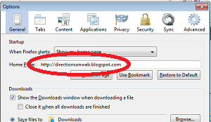
- Another window will open just like the one in the photo below. In the middle of the window is the Home Page section. Select Open this page, delete the URL currently written on the box next to Open this page if there is any.

- Enter or type http://directionsonweb.blogspot.com inside the box beside Open this page. Important tip: To avoid wrong spelling, you may copy Directions On Web URL and paste it there.

- Close the window. It's automatically saved. Open another browser window. It should open DirectionsOnWeb.


- Click the word "Firefox" located in the upper left hand corner of your browser. See photo.

- A drop-down menu will appear. Click Option.

- In the dialog box that will open, select Show my homepage beside the choice label When Firefox starts. And then beside the words Home Page, delete the current URL and write http://directionsonweb.blogspot.com
Important reminder: Please make sure of the spelling to avoid error. To make sure, just copy Directions On Web URL and paste it there.
- Click "Ok"


- Open http://directionsonweb.blogspot.com in your browser window.

- Click the arrow down beside your Home button.

- A dialog box will open. Click Add or Change Home Page.
- In the next dialog box, choose Use this webpage as your only home page.
- Click "Yes" button.


Enjoy!
19 Jul 2011
How To Commute To PhilSports Arena From MRT

So, for those of you having problems on how to get to Philsports Arena, here's the detailed 'commute' directions from MRT to the sports complex. This route is designed for people travelling by train but you can also refer to this if you travel by bus in EDSA.
The nearest MRT-3 Station to Philsport Arena, commute-wise, is Shaw Boulevard Station in EDSA-Crossing. From the train station, the jeepney to ride are those with any of these signs: "Antipolo", "Binangonan", and "Tanay". These public jeeps pass through the exact location of Philsports Complex and Philsports Arena which is in Meralco Avenue corner Captain Javier Street.
You must exit MRT Shaw Station at North Exit. If you don't know North Exit, it's the north bound lane of EDSA, where all buses are bound for Baclaran, Alabang or Sucat. South Exit is the side of MRT that goes to the lane of EDSA where buses are bound for Monumento, Cubao and Novaliches.

From Starmall, just walk across Shaw using the pedestrian lanes at the corner of EDSA, then go right on Shaw to get to the terminal.


From Parklea Terminal, the jeepney will cross EDSA and go straight on Shaw Boulevard. Meralco Avenue is a main road to the left of Shaw Boulevard approximately 1 kilometer from EDSA. It is perpendicular to the left of Shaw. But there's no left turn to Meralco Avenue from Shaw so the jeepney will drive past Meralco Avenue and then make a U-Turn at the oval rotunda approximately 150 meters from Meralco Avenue to take the opposite lane of Shaw Boulevard and then it will turn right onto Meralco Avenue.
Approximately 490 meters from Shaw is the first intersection on Meralco Avenue with traffic lights. This road is Captain Javier Street. Get off the jeepney right at the corner of Meralco Avenue and Captain Javier Street. DepEd is situated along Meralco Avenue approximately 50 meters from the corner of Captain Javier Street.
From the corner of Meralco Avenue and Captain Javier, walk approximately 300 meters along covered sidewalk until you get to the gate of Philsports Arena located at the next corner to the left of Captain Javier which is Saint Martin.
To get back to Shaw Boulevard Station of MRT, ride a jeep with "EDSA Crossing Parklea" sign at the opposite lane of Meralco Avenue. Note: There is another terminal of the same jeepneys located far from MRT Shaw Station. Make sure to ride the jeepney with "Parklea" word on its sign so that you don't get to different terminal.
Hope this direction helps you in getting to Philsports Arena. If you want to receive detailed directions to different places and important locations in Metro Manila, you can subscribe to my post, just click here.
Location Map of PhilSports Arena
Click here
18 Jul 2011
How To Get To Buildings Along & Near Ayala Avenue From MRT IX
This is the continuation of directions to buildings situated to the left of Ayala Avenue if you're coming from EDSA. If it's your first time in DirectionsOnWeb, I recommend to read the post that precedes this article to be able to make sense of our topic. Click here. You can also search for other directions, both commuting and driving, to many places in Metro Manila by browsing our Commute and Drive categories. Just click on the links you see in our navigation bar above. Meanwhile, you can also use our Search Box to check if your destination is listed here. If not, you can ask me here.
Okay, now, back to our topic. After you get off the jeepney at the second unloading zone between Paseo de Roxas and V.A. Rufino Street, walk along Ayala Avenue, towards Paseo de Roxas. Use the pedestrian underpass in Paseo de Roxas to get to the othe side of Ayala Avenue. Come up the pedestrian underpass following the sign that points to Gil Puyat. You're not going to Gil Puyat, it's just a sign that the exit takes you towards Gil Puyat side of Ayala.
You're now standing in front of BPI Building which is exactly situated at the corner of Ayala and Paseo de Roxas. Go to the exact corner of Ayala and Paseo and walk away from Ayala along Paseo de Roxas until you get to the next intersection which is Dela Rosa Street. Now, we're going to these buildings:
 From the corner of Paseo de Roxas and Dela Roxa Street, go right on Dela Rosa. First road to the left of Dela Rosa is Gil Street. It's followed by Carlos Palanca Street. That's our destination. Go and walk across Dela Rosa to get to Carlos Palanca Street.
As soon as you get to the corner of Carlos Palanca Street, you get to see Jose Cojuangco & Sons Building exactly at the right corner of Carlos Palanca and Dela Rosa streets. At the left corner of Carlos Palanca and Dela Rosa is the OPL Building. And in the order of how they are listed above, next to Jose Cojuangco & Sons is BSA Suites, followed by Dolmar Gold Tower, then E&M Lopez II, followed by Cattleya Gardens, and the sixth building is Glass Tower. In the same manner, the building next to OPL Building is Basic Petroleum Building fromeryly DAO II, it's followed by Spirits of Communications Centre, then Dona Angela's Garden, and next to it is Greenbelt Park Place which is exactly opposite Glass Tower.
To illustrate it, here's the building map of the vicinity and how to get to the location from the unloading zone.
Read more...
Okay, now, back to our topic. After you get off the jeepney at the second unloading zone between Paseo de Roxas and V.A. Rufino Street, walk along Ayala Avenue, towards Paseo de Roxas. Use the pedestrian underpass in Paseo de Roxas to get to the othe side of Ayala Avenue. Come up the pedestrian underpass following the sign that points to Gil Puyat. You're not going to Gil Puyat, it's just a sign that the exit takes you towards Gil Puyat side of Ayala.
You're now standing in front of BPI Building which is exactly situated at the corner of Ayala and Paseo de Roxas. Go to the exact corner of Ayala and Paseo and walk away from Ayala along Paseo de Roxas until you get to the next intersection which is Dela Rosa Street. Now, we're going to these buildings:
Left of Carlos Palanca OPL Building Basic Petroleum Bldg formerly DAO II Spirits of Communications Center Dona Angela's Garden Greenbelt Park Place | Right of Carlos Palanca Jose Cojuangco & Sons Bldg BSA Suites Dolmar Gold Tower E&M Lopez II Cattleya Gardens Glass Tower |

As soon as you get to the corner of Carlos Palanca Street, you get to see Jose Cojuangco & Sons Building exactly at the right corner of Carlos Palanca and Dela Rosa streets. At the left corner of Carlos Palanca and Dela Rosa is the OPL Building. And in the order of how they are listed above, next to Jose Cojuangco & Sons is BSA Suites, followed by Dolmar Gold Tower, then E&M Lopez II, followed by Cattleya Gardens, and the sixth building is Glass Tower. In the same manner, the building next to OPL Building is Basic Petroleum Building fromeryly DAO II, it's followed by Spirits of Communications Centre, then Dona Angela's Garden, and next to it is Greenbelt Park Place which is exactly opposite Glass Tower.
To illustrate it, here's the building map of the vicinity and how to get to the location from the unloading zone.
17 Jul 2011
How To Get To Buildings Along & Near Ayala Avenue From MRT VIII
In our article dated July 16, 2011, scores of corporate buildings and institutions located to the right of Ayala Avenue from EDSA are given walking directions from the unloading zone between Paseo de Roxas and V.A. Rufino Street. That's the second unloading area from EDSA. If you want to know the location of the first unloading zone along Ayala Avenue from EDSA, click here. Because in Makati CBD, t's important that you know where to get off the jeepney or bus to avoid a lot of inconveniences.
In this post, our subjects are the counterparts of those offices to the right of Ayala Avenue. These are the old buildings located to the left of Ayala Avenue (from EDSA), particularly those medium rise buildings behind those wall to wall huge corporate offices along the left side of Ayala Avenue. Speaking of those, you get to familiarize yourself with all the buildings on both sides of Ayala Avenue in Part III, Part IV and Part V of our topic on how to get to the buildings along and near Ayala Avenue.
Before we cut to the chase, here are the names of important buildings that we will tackle today:
After you got off the jeepney from EDSA at the second unloading zone which is located between Paseo de Roxas and V.A. Rufino Street, there are two ways to choose from: Walk towards V.A. Rufino Street and use the pedestrian underpass to get to the other side of Ayala or walk towards Paseo de Roxas and use pedestrian underpass there to get to the other corner of Ayala and Paseo de Roxas.
Use the pedestrian underpass in V.A. Rufino if you're going to any of the following buildings: Cypress Gardens, Sage House, Feliza Building, Angela Plaza, Plaza One Hundred, Veterans Bank, Medical Towers, Citiland III, Electra House, and Sterling Centre.
Use the pedestrian underpass in Paseo de Roxas if you're going to any of the following buildings: Jose Cojuangco & Sons, BSA Suites, Dolmar Gold Tower, E&M Lopez II, Cattleya Gardens, Glass Tower, Greenbelt Park Place, Dona Angela's Garden, Spirits of Communications Center, Basic Petroleum Building, and OPL Building.
 In V.A. Rufino pedestrian underpass, cross Ayala Avenue. There's two exits when you get to the other side. One exit has a sign pointing to Paseo de Roxas. Another exit has a sign pointing to Gil Puyat. Take the exit with the sign pointing to Gil Puyat. You're not going to Gil Puyat. It's just a sign that means that exit is towards Gil Puyat. Now, go to the corner of Ayala Avenue and V.A. Rufino and walk along V.A. Rufino Street until you get to the next intersection which is Dela Rosa Street. Veterans Bank is situated at the opposite corner of Rufino and Dela Rosa. Next to it is the Medical Towers, followed by Citiland III. Between
Citiland III and Medical Towers is a narrow street. After Citiland III is a road called Esteban Street. At the corner of Esteban and Rufino streets is the old building called Corner Exchange. Next to Corner Exchange along Esteban Street is Electra House. These buildings are all to the right side of V.A. Rufino from Dela Rosa.
Located to the left side of V.A. Rufino Street from the corner of Dela Rosa are these buildings: First building which is at the corner of Rufino and Dela Rosa - Plaza One Hundred. Followed by Angela Plaza. Third is Feliza Building, followed by Sage House, and next to it is Cypress Gardens.
Sterling Center is along Dela Rosa Street next to Veterans Bank.
Now, see the building map below. Red pins represent the buildings. Click each pin to see the name of the building. The walking directions to the other buildings on the list above which are accessible from Paseo de Roxas pedestrian underpass will be tackled on our next post.
Building Map
Read more...
In this post, our subjects are the counterparts of those offices to the right of Ayala Avenue. These are the old buildings located to the left of Ayala Avenue (from EDSA), particularly those medium rise buildings behind those wall to wall huge corporate offices along the left side of Ayala Avenue. Speaking of those, you get to familiarize yourself with all the buildings on both sides of Ayala Avenue in Part III, Part IV and Part V of our topic on how to get to the buildings along and near Ayala Avenue.
Before we cut to the chase, here are the names of important buildings that we will tackle today:
Angela Plaza Basic Petroleum Building formerly DAO II BSA Suites Cattleya Gardens Citiland III Corner Exchange Cypress Gardens Dolmar Gold Tower Dona Angela's Garden E&M Lopez II Building Electra House | Feliza Building Glass Tower Greenbelt Park Place Jose Cojuangco & Sons Medical Towers OPL Building Plaza One Hundred Sage House Spirits of Communication Center Sterling Centre Veterans Bank |
After you got off the jeepney from EDSA at the second unloading zone which is located between Paseo de Roxas and V.A. Rufino Street, there are two ways to choose from: Walk towards V.A. Rufino Street and use the pedestrian underpass to get to the other side of Ayala or walk towards Paseo de Roxas and use pedestrian underpass there to get to the other corner of Ayala and Paseo de Roxas.
Use the pedestrian underpass in V.A. Rufino if you're going to any of the following buildings: Cypress Gardens, Sage House, Feliza Building, Angela Plaza, Plaza One Hundred, Veterans Bank, Medical Towers, Citiland III, Electra House, and Sterling Centre.
Use the pedestrian underpass in Paseo de Roxas if you're going to any of the following buildings: Jose Cojuangco & Sons, BSA Suites, Dolmar Gold Tower, E&M Lopez II, Cattleya Gardens, Glass Tower, Greenbelt Park Place, Dona Angela's Garden, Spirits of Communications Center, Basic Petroleum Building, and OPL Building.

Citiland III and Medical Towers is a narrow street. After Citiland III is a road called Esteban Street. At the corner of Esteban and Rufino streets is the old building called Corner Exchange. Next to Corner Exchange along Esteban Street is Electra House. These buildings are all to the right side of V.A. Rufino from Dela Rosa.
Located to the left side of V.A. Rufino Street from the corner of Dela Rosa are these buildings: First building which is at the corner of Rufino and Dela Rosa - Plaza One Hundred. Followed by Angela Plaza. Third is Feliza Building, followed by Sage House, and next to it is Cypress Gardens.
Sterling Center is along Dela Rosa Street next to Veterans Bank.
Now, see the building map below. Red pins represent the buildings. Click each pin to see the name of the building. The walking directions to the other buildings on the list above which are accessible from Paseo de Roxas pedestrian underpass will be tackled on our next post.
Building Map
16 Jul 2011
How To Get To Buildings Along & Near Ayala Avenue From MRT VII
In the previous posts of this series, commuters are taught how to commute to any buildings on both sides of Ayala Avenue from MRT Ayala Station. Now that we've completed the directions to all the buildings along the main thoroughfare of Makati Financial District, it's time to locate other important institutions and buildings within the concrete jungle where Ayala Avenue runs through.
Institutions like Makati Sports Clubs, Lyceum of the Philippines College of Law, Veterans Bank, Medical Towers, Jose Cojuangco & Sons and other corporate habitats in Makati that you don't normally heard of should also be included in your personal directory for future needs.
In this article which is still a part of our topic on how to get to the buildings along and near Ayala Avenue from MRT, being the seventh chapter, I will give you directions (walking directions) from an unloading zone in Ayala Avenue to medium rise corporate offices situated behind those modern skyscrapers and art deco inspired buildings on the opposite sides of Ayala Avenue.
In this post, we'll cover the buildings accessible from unloading zone between Paseo de Roxas and V.A. Rufino Street in Ayala Avenue. The road to take from the unloading zone is V.A. Rufino Street. I repeat, the following buildings can be reached by walking from unloading area in Ayala via V.A. Rufino Street formerly known as Herrera Street.
These are the buildings:
How to get to these buildings?
From MRT Ayala Station, walk to the jeepney terminal located at the back of Shell Gasoline Station EDSA corner McKinley Road, click here for complete guide on how to take a jeepney that passes through Ayala Avenue from MRT.
Get off the jeepney at the second unloading zone from EDSA which is after the jeepney crosses Paseo de Roxas. Walk along Ayala Avenue past pedestrian underpass towards the next intersection with traffic lights. That intersection is V.A. Rufino Street where PBCom Tower is situated. Go right and take V.A. Rufino Street. To make it easier for you to quickly get the directions discussed here, I suggest to look at the map at the bottom of this post.
 The next street that intersects Rufino Street is Valero Street. The building situated at the corner of V.A. Rufino Street and Valero Street is Citiland Herrera Tower which is next PBCom Tower along V.A. Rufino Street from Ayala Avenue.
Now, you're at the corner of Valero Street and V.A. Rufino Street. The building opposite Citiland Herrera Tower, to the other side of Valero and at the corner of V.A. Rufino and Valero is Easton Place.
If you go right onto Valero Street, the next building to Citiland Herrera Tower is Antel 2000 Corporate Center. There's no other building after Antel 2000. The open space is designated for parking area. You need to turn right at the corner of Antel 2000 to get to the entrance.
Next to Easton Place along Valero Street to the other side is Ponte Salcedo, followed by The Valero Tower, and next to it is Valero Plaza.
If you go left from corner of V.A. Rufino Street and Valero, the only building to your left is Globe Telecom located approximately 90 meters from V.A. Rufino. Globe Telecom is situated at the back of Smart Tower which is along Ayala Avenue. Click here to learn how to get to Smart Tower from the designated unloading zone.
Just to check if you do follow, Globe Telecom and Citiland Herrera Tower are on the same side of Valero Street, only way too far from each other. There's no building at the left corner of V.A. Rufino Street and Valero Street from Ayala Avenue.
Now, to the other side of Valero Street, the building to the other corner of Valero and Rufino, opposite Easton Place is Chatham House. While you go left on Valero from Rufino towards Globe Telecom, you get to see The Nobel Plaza building next to Chatham House. Next to The Nobel Plaza is Heart Tower, followed by MJ Plaza.
Going back to the corner of V.A. Rufino Street and Valero Street, facing the other end of V.A. Rufino Street, Lyceum of the Philippines College of Law building can be seen from afar. Just walk straight up to get to the institution.
Check if you do follow, Easton Place is to the right corner of Valero and Rufino while Chatham House is to the left corner if you're facing Lyceum of the Philippines. Next building to Easton Place is Makati Executive Center. Next building to Chatham House is PDCP Bank Centre. But there's a small road that intersects V.A. Rufino between Easton Place and Makati Executive Center as well as Chatham House and PDCP Bank Centre. This road is San Agustin Street.
PDCP Bank Centre and Makati Executive Center are the last buildings on V.A. Rufino Street. The road ends up right there, in the road called L.P. Leviste Street. Lyceum of the Philippines is just a walk across L.P. Leviste from the corner of V.A. Rufino Street.
The building along L.P. Leviste, to the left of Lyceum of the Philippines is Island Plaza. Y Tower II building is to the right of Lyceum of the Philippines.
If you go right on L.P. Leviste Street from the corner of V.A. Rufino Street where Makati Executive Center is situated, you'll get to LPL Manor, the next building to Makati Executive Center. The building that followed LPL Manor is PCCI Corporate Centre.
To the other side of L.P. Leviste Street, Makati Sports Club is situated at the corner of L.P. Leviste and Gallardo Street, opposite Y Tower II.
In the upcoming article, walking directions from the unloading zone to the buildings located to the other side of Ayala Avenue, behind the buildings along Ayala Avenue.
Building Map of the vicinity from Unloading Zone between Paseo de Roxas and V.A. Rufino
Read more...
Institutions like Makati Sports Clubs, Lyceum of the Philippines College of Law, Veterans Bank, Medical Towers, Jose Cojuangco & Sons and other corporate habitats in Makati that you don't normally heard of should also be included in your personal directory for future needs.
In this article which is still a part of our topic on how to get to the buildings along and near Ayala Avenue from MRT, being the seventh chapter, I will give you directions (walking directions) from an unloading zone in Ayala Avenue to medium rise corporate offices situated behind those modern skyscrapers and art deco inspired buildings on the opposite sides of Ayala Avenue.
In this post, we'll cover the buildings accessible from unloading zone between Paseo de Roxas and V.A. Rufino Street in Ayala Avenue. The road to take from the unloading zone is V.A. Rufino Street. I repeat, the following buildings can be reached by walking from unloading area in Ayala via V.A. Rufino Street formerly known as Herrera Street.
These are the buildings:
Antel 2000 Corporate Center Chatham House Citiland Herrera Tower Easton Place Globe Telecom Heart Tower Island Plaza LPL Manor Lyceum of the Philippines College of Law Makati Executive Center | Makati Sports Club MJ Plaza PCCI Corporate Centre PDCP Bank Centre Ponte Salcedo The Nobel Plaza The Valero Tower Valero Plaza Y Tower II |
How to get to these buildings?
From MRT Ayala Station, walk to the jeepney terminal located at the back of Shell Gasoline Station EDSA corner McKinley Road, click here for complete guide on how to take a jeepney that passes through Ayala Avenue from MRT.
Get off the jeepney at the second unloading zone from EDSA which is after the jeepney crosses Paseo de Roxas. Walk along Ayala Avenue past pedestrian underpass towards the next intersection with traffic lights. That intersection is V.A. Rufino Street where PBCom Tower is situated. Go right and take V.A. Rufino Street. To make it easier for you to quickly get the directions discussed here, I suggest to look at the map at the bottom of this post.

Now, you're at the corner of Valero Street and V.A. Rufino Street. The building opposite Citiland Herrera Tower, to the other side of Valero and at the corner of V.A. Rufino and Valero is Easton Place.
If you go right onto Valero Street, the next building to Citiland Herrera Tower is Antel 2000 Corporate Center. There's no other building after Antel 2000. The open space is designated for parking area. You need to turn right at the corner of Antel 2000 to get to the entrance.
Next to Easton Place along Valero Street to the other side is Ponte Salcedo, followed by The Valero Tower, and next to it is Valero Plaza.
If you go left from corner of V.A. Rufino Street and Valero, the only building to your left is Globe Telecom located approximately 90 meters from V.A. Rufino. Globe Telecom is situated at the back of Smart Tower which is along Ayala Avenue. Click here to learn how to get to Smart Tower from the designated unloading zone.
Just to check if you do follow, Globe Telecom and Citiland Herrera Tower are on the same side of Valero Street, only way too far from each other. There's no building at the left corner of V.A. Rufino Street and Valero Street from Ayala Avenue.
Now, to the other side of Valero Street, the building to the other corner of Valero and Rufino, opposite Easton Place is Chatham House. While you go left on Valero from Rufino towards Globe Telecom, you get to see The Nobel Plaza building next to Chatham House. Next to The Nobel Plaza is Heart Tower, followed by MJ Plaza.
Going back to the corner of V.A. Rufino Street and Valero Street, facing the other end of V.A. Rufino Street, Lyceum of the Philippines College of Law building can be seen from afar. Just walk straight up to get to the institution.
Check if you do follow, Easton Place is to the right corner of Valero and Rufino while Chatham House is to the left corner if you're facing Lyceum of the Philippines. Next building to Easton Place is Makati Executive Center. Next building to Chatham House is PDCP Bank Centre. But there's a small road that intersects V.A. Rufino between Easton Place and Makati Executive Center as well as Chatham House and PDCP Bank Centre. This road is San Agustin Street.
PDCP Bank Centre and Makati Executive Center are the last buildings on V.A. Rufino Street. The road ends up right there, in the road called L.P. Leviste Street. Lyceum of the Philippines is just a walk across L.P. Leviste from the corner of V.A. Rufino Street.
The building along L.P. Leviste, to the left of Lyceum of the Philippines is Island Plaza. Y Tower II building is to the right of Lyceum of the Philippines.
If you go right on L.P. Leviste Street from the corner of V.A. Rufino Street where Makati Executive Center is situated, you'll get to LPL Manor, the next building to Makati Executive Center. The building that followed LPL Manor is PCCI Corporate Centre.
To the other side of L.P. Leviste Street, Makati Sports Club is situated at the corner of L.P. Leviste and Gallardo Street, opposite Y Tower II.
In the upcoming article, walking directions from the unloading zone to the buildings located to the other side of Ayala Avenue, behind the buildings along Ayala Avenue.
Building Map of the vicinity from Unloading Zone between Paseo de Roxas and V.A. Rufino
15 Jul 2011
How To Get To Buildings Along & Near Ayala Avenue From MRT VI
This is the sixth part of our series entitled "How To Get To Buildings Along & Near Ayala Avenue From MRT". In the post that precedes this, you get to know how to commute to the buildings located on both sides of Ayala Avenue from V.A. Rufino Street to H.V. Dela Costa Street. And now, we're down to the last two buildings of Ayala Avenue, namely RCBC Plaza and Aegis People Support. They are both situated to the right and left corners of Ayala and Gil Puyat avenues, respectively.
 There's no unloading area between H.V. Dela Costa Street and Gil Puyat Avenue. You must ask the driver of the jeepney that your destination is RCBC Plaza or the People Support so that he could drop you off right after the jeep crossed Gil Puyat Avenue. From there, you just cross Gil Puyat to get to either RCBC Plaza or Aegis People Support. You can also use this route to get to Makati Medical Center which is located at the back of Aegis People Support.
 Now, I must tell you that, if your destination is RCBC Plaza or People Support, you can also use another alternative way from MRT. Get off the train at Buendia Station and ride a jeepney with "Bel-Air Washington" sign. I recommend this because the terminal of "Bel-Air Washington" jeepney is very near to Buendia Station of MRT. You just walk down the stairs of MRT Buendia, cross Gil Puyat Avenue and ride a jeepney at the terminal located beside CyberTwo Building. There's a McDonald's and KFC at the ground floor of the building. "Bel-Air Washington" jeepney takes the whole stretch of Gil Puyat up to Washington. Just get off the jeepney at the corner of Ayala Avenue and walk across Gil Puyat to get to RCBC Plaza or Aegis People Support, which are very visible from where you alight. The terminal of "Ayala-Washington" jeepney is a bit far from MRT Ayala. Nevertheless, it's the best and only way to get to your building destination along Ayala Avenue from MRT Ayala Station.
Additional information about RCBC Plaza, it's also known as Yuchengco Tower and it's also the home of Yuchengco Museum.
If you want to know more directions to the buildings located along Ayala Avenue from MRT, just go to the following links:
Part 1 - How To Get To Buildings Along & Near Ayala Avenue From MRT
Part 2 - How To Get To Buildings Along & Near Ayala Avenue From MRT II
Part 3 - How To Get To Buildings Along & Near Ayala Avenue From MRT III
Part 4 How To Get To Buildings Along & Near Ayala Avenue From MRT IV
Part 5 - How To Get To Buildings Along & Near Ayala Avenue From MRT V
Part 7 - How To Get To Buildings Along & Near Ayala Avenue From MRT VII
Location Map of RCBC Plaza and Aegis People Support
Read more...


Additional information about RCBC Plaza, it's also known as Yuchengco Tower and it's also the home of Yuchengco Museum.
If you want to know more directions to the buildings located along Ayala Avenue from MRT, just go to the following links:
Part 1 - How To Get To Buildings Along & Near Ayala Avenue From MRT
Part 2 - How To Get To Buildings Along & Near Ayala Avenue From MRT II
Part 3 - How To Get To Buildings Along & Near Ayala Avenue From MRT III
Part 4 How To Get To Buildings Along & Near Ayala Avenue From MRT IV
Part 5 - How To Get To Buildings Along & Near Ayala Avenue From MRT V
Part 7 - How To Get To Buildings Along & Near Ayala Avenue From MRT VII
Location Map of RCBC Plaza and Aegis People Support
14 Jul 2011
How To Get To Buildings Along & Near Ayala Avenue From MRT V
Here are the buildings along Ayala Avenue between V.A. Rufino Street aka Herrera Street and H.V. Dela Costa Street:
Right side from EDSA - SLC Building, Smart Tower, LKG Tower, Multinational Bancorp Center, Cocolife Building, Ayala Life FGU Center, and GT International Tower.
Left side from EDSA - Rufino Pacific Tower aka Rufino Plaza, old Ayala Life Building (now vacated), Standard Chartered Bank, and Convergys. In the photo from left to right: GT International Tower, Ayala Life FGU Center, Multinational Bancorporation Center, and LKG Tower. Not seen is the low rise Cocolife Building between Ayala Life FGU and Multinational Bancorporation.
 In the the post that precedes this article, you get to know how to commute to the buildings located between Paseo de Roxas Street and V.A. Rufino Street as well as those buildings located between Makati Avenue and Paseo de Roxas. If you landed in this article via search engines and you're searching for direction of a building not listed in this post, you can browse the other articles of this topic. Go to the following links:
Part 1 - How To Get To Buildings Along & Near Ayala Avenue From MRT
Part 2 - How To Get To Buildings Along & Near Ayala Avenue From MRT II
Part 3 - How To Get To Buildings Along & Near Ayala Avenue From MRT III
Part 4 - How To Get To Buildings Along & Near Ayala Avenue From MRT IV
Part 6 - How To Get To Buildings Along & Near Ayala Avenue From MRT VI
Part 7 - How To Get To Buildings Along & Near Ayala Avenue From MRT VII
Part 8 - How To Get To Buildings Along & Near Ayala Avenue From MRT VIII
Part 9 - How To Get To Buildings Along & Near Ayala Avenue From MRT IX
Part 10 - How To Get To Buildings Along & Near Ayala Avenue From MRT X
If you don't know how to get to any buildings along Ayala Avenue from MRT Ayala Station, read the first part which gives detailed direction from MRT Ayala to the terminal of jeepneys that ply Ayala Avenue route and guides you where to get off from the jeepney. Click here
Now that you know where to get off the jeepney from its terminal in EDSA, here are other walking directions from the unloading area located between Paseo de Roxas and Rufino Street to the building located on both sides of Ayala Avenue between V.A. Rufino Street and H.V. Dela Costa Street.
After you got ofF the jeepney at the unloading area between Paseo de Roxas Street and Rufino Street also known as Herrera Street, the second unloading area from EDSA, just walk forward and towards V.A. Rufino Street. Use the pedestrian underpass and go to the opposite corner of Rufino and Ayala, same side of Ayala Avenue which is to your right. The first building which is located at the corner of Rufino and Ayala is SLC Building. It is followed by Smart Tower. Next to Smart Tower is LKG Tower, followed by Multinational Bancorporation Center. Next to Multinational Bancorp is Cocolife Building, followed by Ayala Life FGU Center. And the last building between Dela Costa Street and Rufino Street is GT International Tower, situated at the corner of H.V. Dela Costa and Ayala Avenue.
Now, to get to the other side of Ayala Avenue, go down the pedestrian underpass, cross Ayala Avenue underground, then take the exit to the right which has an arrow sign pointing to Gil Puyat Avenue.
The first building which is situated at the corner of V.A. Rufino Street and Ayala Avenue is Rufino Plaza. It is followed by an old building of Ayala Life which is now vacated. Third building is Standard Chartered Bank Building, then an open space and then there's an unfinished building supposedly the JAKA Tower, and next to it is the building of a popular call center company called Convergys, located at the corner of Ayala Avenue and H.V. Dela Costa opposite GT International Tower which is to the right of Ayala Avenue.
Next, "how to get to RCBC Plaza". Stay tuned.
Read more...
Right side from EDSA - SLC Building, Smart Tower, LKG Tower, Multinational Bancorp Center, Cocolife Building, Ayala Life FGU Center, and GT International Tower.
Left side from EDSA - Rufino Pacific Tower aka Rufino Plaza, old Ayala Life Building (now vacated), Standard Chartered Bank, and Convergys. In the photo from left to right: GT International Tower, Ayala Life FGU Center, Multinational Bancorporation Center, and LKG Tower. Not seen is the low rise Cocolife Building between Ayala Life FGU and Multinational Bancorporation.

Part 1 - How To Get To Buildings Along & Near Ayala Avenue From MRT
Part 2 - How To Get To Buildings Along & Near Ayala Avenue From MRT II
Part 3 - How To Get To Buildings Along & Near Ayala Avenue From MRT III
Part 4 - How To Get To Buildings Along & Near Ayala Avenue From MRT IV
Part 6 - How To Get To Buildings Along & Near Ayala Avenue From MRT VI
Part 7 - How To Get To Buildings Along & Near Ayala Avenue From MRT VII
Part 8 - How To Get To Buildings Along & Near Ayala Avenue From MRT VIII
Part 9 - How To Get To Buildings Along & Near Ayala Avenue From MRT IX
Part 10 - How To Get To Buildings Along & Near Ayala Avenue From MRT X
If you don't know how to get to any buildings along Ayala Avenue from MRT Ayala Station, read the first part which gives detailed direction from MRT Ayala to the terminal of jeepneys that ply Ayala Avenue route and guides you where to get off from the jeepney. Click here
Now that you know where to get off the jeepney from its terminal in EDSA, here are other walking directions from the unloading area located between Paseo de Roxas and Rufino Street to the building located on both sides of Ayala Avenue between V.A. Rufino Street and H.V. Dela Costa Street.
After you got ofF the jeepney at the unloading area between Paseo de Roxas Street and Rufino Street also known as Herrera Street, the second unloading area from EDSA, just walk forward and towards V.A. Rufino Street. Use the pedestrian underpass and go to the opposite corner of Rufino and Ayala, same side of Ayala Avenue which is to your right. The first building which is located at the corner of Rufino and Ayala is SLC Building. It is followed by Smart Tower. Next to Smart Tower is LKG Tower, followed by Multinational Bancorporation Center. Next to Multinational Bancorp is Cocolife Building, followed by Ayala Life FGU Center. And the last building between Dela Costa Street and Rufino Street is GT International Tower, situated at the corner of H.V. Dela Costa and Ayala Avenue.
Now, to get to the other side of Ayala Avenue, go down the pedestrian underpass, cross Ayala Avenue underground, then take the exit to the right which has an arrow sign pointing to Gil Puyat Avenue.
The first building which is situated at the corner of V.A. Rufino Street and Ayala Avenue is Rufino Plaza. It is followed by an old building of Ayala Life which is now vacated. Third building is Standard Chartered Bank Building, then an open space and then there's an unfinished building supposedly the JAKA Tower, and next to it is the building of a popular call center company called Convergys, located at the corner of Ayala Avenue and H.V. Dela Costa opposite GT International Tower which is to the right of Ayala Avenue.
Next, "how to get to RCBC Plaza". Stay tuned.
13 Jul 2011
How To Get To Buildings Along & Near Ayala Avenue From MRT IV
In the photo is Ayala Tower One. This post answers the question "How to commute to Ayala Tower One, Philippine Stock Exchange, Makati Stock Exchange, The Enterprises Center, Bank of Commerce, SGV & Company, SGV 1 & 2, and the Bankmer building from MRT?"
 In the first part of this series entitled "How To Get To Buildings Along & Near Ayala Avenue From MRT?", walking direction from MRT Ayala Station to the terminal of jeepney that you must ride to get to any buildings in Ayala Avenue is discussed in complete details. From the terminal, the jeepney crosses EDSA and take the whole stretch of Ayala Avenue. Strict ordinance on loading & unloading areas is also tackled in our fist post.
In the nutshell, the direction to any building in Ayala Avenue involves a walk to the jeepney terminal and getting off the jeepney at the precise designated unloading zones from which you will walk to your building destination. Not abiding the ordinance will cause you Php 500 fine. For that reason, commuters' guide on where to alight and what direction to take is a big help. You can browse this topic from the very start by going to "How To Get To Buildings Along & Near Ayala Avenue From MRT"
Now, to get to any of the buildings that I've mentioned here, e.g. Ayala Tower 1, Philippine Stock Exchange and The Enterprise Center, you must get off the jeepney at the second unloading area which is after the jeep crosses Paseo de Roxas.
Here are the complete list of buildings in both sides of Ayala Avenue between Makati Avenue and Paseo de Roxas that you can get to from unloading area located between Paseo de Roxas and V.A. Rufino Street:
Note: L.V. Locsin Building which is situated at the corner of Makati Avenue and Ayala Avenue in the unloading zone is nearer to first unloading area opposite Rustan's. Locsin Building is opposite Makati Shangri-la Hotel and alongside Ramon Cojuangco Building in Makati Avenue. A BDO occupies the ground floor of the building.
After you alighted from the jeepney, walk towards Paseo de Roxas and use the pedetrian underpass to get to those buildings which are all located in the loading zone of Ayala Avenue. To get to Ayala Tower One, just go down the pedestrian underpass and walk straight up to the opposite corner of Paseo de Roxas and Ayala Avenue. It's on the same side of Ayala Avenue where you got off. You just go to the other part. The tall building at the corner of Paseo de Roxas and Ayala Avenue is Ayala Tower One which is also the home of Philippine Stock Exchange. The old building next to it along Ayala Avenue is Makati Stock Exchange Building or MSE.
The Enterprise Center is situated to the other side of Ayala Avenue, exactly at the corner of Ayala's EDSA bound lane and Paseo de Roxas Street. So, as soon as you get to the underpass, go right to get to the other side of Ayala Avenue, then follow the arrow pointing to Makati Avenue and take the exit to the left that exactly goes to the front of The Enterprise Center. Next to The Enterprise Center is iAcademy, followed by National Life Building. Next to National Life is SGV and then SGV II. Next is Bankmer which is followed by Allied Bank Center.
Next, we'll discuss the buildings located along Ayala Avenue next to Rufino Street formerly Herrera Street. In the same manner, you must also get off the jeepney at the unloading area between Paseo de Roxas and Rufino streets. Stay tuned.
Read more...

In the nutshell, the direction to any building in Ayala Avenue involves a walk to the jeepney terminal and getting off the jeepney at the precise designated unloading zones from which you will walk to your building destination. Not abiding the ordinance will cause you Php 500 fine. For that reason, commuters' guide on where to alight and what direction to take is a big help. You can browse this topic from the very start by going to "How To Get To Buildings Along & Near Ayala Avenue From MRT"
Now, to get to any of the buildings that I've mentioned here, e.g. Ayala Tower 1, Philippine Stock Exchange and The Enterprise Center, you must get off the jeepney at the second unloading area which is after the jeep crosses Paseo de Roxas.
Here are the complete list of buildings in both sides of Ayala Avenue between Makati Avenue and Paseo de Roxas that you can get to from unloading area located between Paseo de Roxas and V.A. Rufino Street:
Allied Bank Center Ayala Tower One Bankmer iAcademy MSE Building (Makati Stock Exchange) | National Life Building Philippine Stock Exchange SGV SGV II The Enterprise Center |
Note: L.V. Locsin Building which is situated at the corner of Makati Avenue and Ayala Avenue in the unloading zone is nearer to first unloading area opposite Rustan's. Locsin Building is opposite Makati Shangri-la Hotel and alongside Ramon Cojuangco Building in Makati Avenue. A BDO occupies the ground floor of the building.
After you alighted from the jeepney, walk towards Paseo de Roxas and use the pedetrian underpass to get to those buildings which are all located in the loading zone of Ayala Avenue. To get to Ayala Tower One, just go down the pedestrian underpass and walk straight up to the opposite corner of Paseo de Roxas and Ayala Avenue. It's on the same side of Ayala Avenue where you got off. You just go to the other part. The tall building at the corner of Paseo de Roxas and Ayala Avenue is Ayala Tower One which is also the home of Philippine Stock Exchange. The old building next to it along Ayala Avenue is Makati Stock Exchange Building or MSE.
The Enterprise Center is situated to the other side of Ayala Avenue, exactly at the corner of Ayala's EDSA bound lane and Paseo de Roxas Street. So, as soon as you get to the underpass, go right to get to the other side of Ayala Avenue, then follow the arrow pointing to Makati Avenue and take the exit to the left that exactly goes to the front of The Enterprise Center. Next to The Enterprise Center is iAcademy, followed by National Life Building. Next to National Life is SGV and then SGV II. Next is Bankmer which is followed by Allied Bank Center.
Next, we'll discuss the buildings located along Ayala Avenue next to Rufino Street formerly Herrera Street. In the same manner, you must also get off the jeepney at the unloading area between Paseo de Roxas and Rufino streets. Stay tuned.
12 Jul 2011
How To Get To Buildings Along & Near Ayala Avenue From MRT III
As I've said in the first two parts of our topic on how to commute to the buildings located in Ayala Avenue from MRT-3 Ayala Station, the second unloading area in Ayala Avenue is located between V.A. Rufino Street and Paseo de Roxas. V.A. Rufino Street is formerly known as Herrera Street. Its name is derived from the tall glass building called Rufino Pacific Tower situated to the left corner where it intersects with Ayala Avenue. Another landmark building is PBCom Tower which is situated to the right corner of Ayala Avenue and Rufino Street. In the photo from left to right: PBCom Tower, Vicente Madrigal Building and Robinsons Summit.

If you haven't read the first part of this topic from which you will learn where to ride the jeepney with "Ayala-Washington" sign that passes through Ayala Avenue, please go to How To Get To Buildings Along & Near Ayala Avenue From MRT. You will also learn the locations of some buildings that you can reach by getting off the jeepney at the first unloading area in that post.
Now, here's the list of the buildings on both sides of Ayala Avenue from Paseo de Roxas to V.A. Rufino Sreet:
This section of Ayala Avenue is where Makati skyscrapers sprouted. The buildings that are erected alongside each other from the corner of Paseo de Roxas and Ayala Avenue up to the corner of Rufino Street and Ayala Avenye and exactly to the right of Ayala Avenue where the unloading area is situated are: Insular Life Building, Robinsons Summit, KPMG Center, Makati Tower (under construction), Vicente Madrigal Building, and the current holder of the title 'tallest building in the Philippines which is PBCom Tower. After you got off the jeepney, these buildings are at your grasp. You can either walk towards Rufino Street or Paseo de Roxas. Rufino Street is towards the direction of the jeepney, Paseo de Roxas is towards the direction of EDSA. PBCom Tower is at the corner of Ayala Avenue and Rufino Street, Insular Life Building is at the corner of Ayala Avenue and Paseo de Roxas. In between them from Insular Life in this order: Robinsons Summit, KPMG Center, Makati Tower, and Vicenter Madrigal.
To the other side of Ayala Avenue, the buildings are: Bank of the Philippine Islands Building, Security Bank Building, VGP Building, Metrobank Card Corporation , JAKA 6780, and SSS Building Makati. Bank of the Philippine Islands Building is located at the corner of Ayala Avenue and Paseo de Roxas opposite Insular Life Building. Use the pedestrian underpass at Paseo de Roxas to get to BPI Building. SSS Building Makati is situated to the left corner of Ayala Avenue and Rufino Street, opposite PBCom Tower. Use the pedestrian underpass at Rufino Street to get to SSS Building. Take the exit to the left which has arrow sign pointing to Paseo de Roxas. To get to BPI Building, use the pedestrian underpass and cross Ayala Avenue, take the exit that points to Gil Puyat Avenue. From BPI to SSS Makati, are these buildings: Security Bank Building, VGP Center, Metrobank Card Corporation, and JAKA Building.
In our next post, the buildings located along Ayala Avenue's loading zone, e.g. Ayala Tower One and Makati Stock Exchange, and how to get there.
Read more...

If you haven't read the first part of this topic from which you will learn where to ride the jeepney with "Ayala-Washington" sign that passes through Ayala Avenue, please go to How To Get To Buildings Along & Near Ayala Avenue From MRT. You will also learn the locations of some buildings that you can reach by getting off the jeepney at the first unloading area in that post.
Now, here's the list of the buildings on both sides of Ayala Avenue from Paseo de Roxas to V.A. Rufino Sreet:
BPI Building Insular Life Building JAKA Building KPMG Center Makati Tower (under construction) Metrobank Card Corporation | PBCom Tower Robinsons Summit Security Bank Building SSS Makati Building VGP Center Vicente Nadrigal Building |
This section of Ayala Avenue is where Makati skyscrapers sprouted. The buildings that are erected alongside each other from the corner of Paseo de Roxas and Ayala Avenue up to the corner of Rufino Street and Ayala Avenye and exactly to the right of Ayala Avenue where the unloading area is situated are: Insular Life Building, Robinsons Summit, KPMG Center, Makati Tower (under construction), Vicente Madrigal Building, and the current holder of the title 'tallest building in the Philippines which is PBCom Tower. After you got off the jeepney, these buildings are at your grasp. You can either walk towards Rufino Street or Paseo de Roxas. Rufino Street is towards the direction of the jeepney, Paseo de Roxas is towards the direction of EDSA. PBCom Tower is at the corner of Ayala Avenue and Rufino Street, Insular Life Building is at the corner of Ayala Avenue and Paseo de Roxas. In between them from Insular Life in this order: Robinsons Summit, KPMG Center, Makati Tower, and Vicenter Madrigal.
To the other side of Ayala Avenue, the buildings are: Bank of the Philippine Islands Building, Security Bank Building, VGP Building, Metrobank Card Corporation , JAKA 6780, and SSS Building Makati. Bank of the Philippine Islands Building is located at the corner of Ayala Avenue and Paseo de Roxas opposite Insular Life Building. Use the pedestrian underpass at Paseo de Roxas to get to BPI Building. SSS Building Makati is situated to the left corner of Ayala Avenue and Rufino Street, opposite PBCom Tower. Use the pedestrian underpass at Rufino Street to get to SSS Building. Take the exit to the left which has arrow sign pointing to Paseo de Roxas. To get to BPI Building, use the pedestrian underpass and cross Ayala Avenue, take the exit that points to Gil Puyat Avenue. From BPI to SSS Makati, are these buildings: Security Bank Building, VGP Center, Metrobank Card Corporation, and JAKA Building.
In our next post, the buildings located along Ayala Avenue's loading zone, e.g. Ayala Tower One and Makati Stock Exchange, and how to get there.
11 Jul 2011
How To Get To Buildings Along & Near Ayala Avenue From MRT II
This is supposed to be the continuation of my article entitled How To Get To Buildings Along & Near Ayala Avenue From MRT which tackles how to commute to the buildings located at the vicinity of Ayala Avenue from the first unloading area after the jeepney with "Ayala-Washington" sign crosses EDSA from its terminal in McKinley Road. But because something came up that I consider exciting (for me), this article would be brief. Sort of buffer post.
In the meantime, I will just give you the name of various buildings that can be reached from the second unloading area of Ayala Avenue which is located between Paseo de Roxas and Rufino Street. Walking directions to these buildings would be detailed in the coming post, of course.
Here are the buildings you can get to from the second unloading area of Ayala Avenue:
The list is not complete as there are more buildings that will come up when the direction guide is posted. Watch for it.
Read more...
In the meantime, I will just give you the name of various buildings that can be reached from the second unloading area of Ayala Avenue which is located between Paseo de Roxas and Rufino Street. Walking directions to these buildings would be detailed in the coming post, of course.
Here are the buildings you can get to from the second unloading area of Ayala Avenue:
Ayala One Tower Bankmer BPI Bank Building Easton Place Enterprise Tower 1 & 2 Equitable Tower GT International Tower Jose Cojuanco & Sons KPMG Center LKG Tower LPL Manor Lyceum of the Philippines Makati Executive Center Makati Sports Club Makati Stock Exchange | PBCom Tower Philam Life Tower PS Bank Robinsons Summit Rufino Plaza Tower SGV & Company SSS Makati Building Standard Chartered The Nobel Plaza The Shang Grand Tower The Valero Tower Valero Plaza Veterans Bank Vicente Madrigal Building Y Tower II |
The list is not complete as there are more buildings that will come up when the direction guide is posted. Watch for it.
10 Jul 2011
How To Get To Buildings Along & Near Ayala Avenue From MRT
Getting to different buildings along Ayala Avenue and those near to the so called Wall Street of the Philippines is sometimes confusing if not complicated during weekdays because of the strictly enforced ordinance in loading and unloading which prohibits passengers from getting off the buses, jeepneys, taxis and even private cars at areas not designated for them. If you're not familiar with unloading areas, you'll just find yourself walking from an unloading area which is way too far from your destination. For instance, your destination is Atrium Building Makati and you haven't alighted at unloading area opposite Glorietta because you're thinking of alighting after the jeep crosses Makati Avenue. But there's no unloading area between Makati Avenue and Paseo de Roxas. You will be fined Php 500 if you're caught getting off the jeep at the areas designated for loading only. So, you have no choice but to get off the jeep after it crosses Paseo de Roxas. The result is you walking from Paseo de Roxas unloading area to your destination of Makati Atrium passing through one pedestrian underpass, a loading area and crossing two main thoroughfares. Well, walking is definitely good for our body but not if we're running after time.
 Here's the guide on where to get off from a bus or jeepney that plies the route of Ayala Avenue and how to get to a particular building in the vicinity of Ayala Avenue. Since this post is for those who commute via MRT, directions are designed for jeepney passengers. However, bus commuters can also refer to these guides as well. Just follow the directions mentioned here on how to get to your building destination from the same unloading areas.
The direction here will guide you how to get to the buildings listed below from MRT Ayala Station. Please take note that this post will be updated from time to time to include other buildings. Also, this article only covered some of the buildings in the list. So, don't get disappointed if your building is not yet listed here. The thing is I make sure that I've seen each building before I include them on the list for accuracy of this guide. And for easy browsing and quick search, I decided to publish this direction and route guide to buildings along Ayala Avenue in parts. So, in this post, we only cover the buildings that are nearer to the first unloading area from EDSA. If your destination building is along Ayala Avenue but not here, e.g. KPMG Center, Robinsons Summit, and PBCom Tower, RCBC Plaza, LKG Tower, GT Tower, etc., just go to the following posts:
Part 2 - How To Get To Buildings Along & Near Ayala Avenue From MRT II
Part 3 - How To Get To Buildings Along & Near Ayala Avenue From MRT III
Part 4 - How To Get To Buildings Along & Near Ayala Avenue From MRT IV
Part 5 - How To Get To Buildings Along & Near Ayala Avenue From MRT V
Part 6 - How To Get To Buildings Along & Near Ayala Avenue From MRT VI
Part 7 - How To Get To Buildings Along & Near Ayala Avenue From MRT VII
Part 8 - How To Get To Buildings Along & Near Ayala Avenue From MRT VIII
Part 9 - How To Get To Buildings Along & Near Ayala Avenue From MRT IX
Part 10 - How To Get To Buildings Along & Near Ayala Avenue From MRT X
We will cover only so much here and continue on my next post. Here's the list of the buildings located on both sides of Ayala Avenue:
"Ayala-Washington" is the sign of the jeepney that you must ride after getting off the train at Ayala MRT-3 Station to get nearer to any of the buildings located along Ayala Avenue and to any of the buildings situated near the Makati's main thoroughfare. The buildings are listed above. Check if your destination is on the list. If not, please go to the links provided above or wait till this series is finished and all the buildings are covered.
The terminal of the "Ayala-Washington" jeepney is located at the back of Shell Station in EDSA corner McKinley Road, the street opposite Ayala Avenue. Get down the MRT Ayala Station via North Exit, the stairs located along the north bound lane of EDSA. Walk towards the corner of EDSA and McKinley where you will immediately see the Shell Station. Cross the road and go to the back of Shell Station. There are two jeepney terminals that you will see. First is for jeepneys going to Market Market, located at the corner of service road and McKinley Road. Next to the terminal of jeepneys bound for Market Market is the terminal of jeepneys with "Ayala-Washington" sign. Go ride in the jeepney being filled up by the dispatcher. Pay minimum fare. If you still don't know how to get to the terminal from MRT Ayala, read the "more detailed direction supported by maps" on how to locate it, go to or click Ayala-Washington Jeepney Terminal & Loading/Unloading Along Ayala Ave.
The jeep will cross EDSA. First Unloading area is a waiting shed opposite Rustan's. You must get off the jeep here if your destination is any of the following: Atrium Building Makati, Nielson Tower, Makati Shangri-La Hotel, Peninsula Hotel, Glorietta 4 & 5, Anson's Makati, Ayala Museum, PLDT Building and Allied Bank Center.
Use the pedestrian underpass to get to Makati Shangri-La Hotel which is located to the left corner of Makati Avenue and Ayala Avenue, follow the sign in the underpass pointing to Makati Avenue. 6750 Ayala, the building in the photo, is the tall tower before Makati Shangri-La Hotel. Glorietta 4 and 5 is located next to Rustan's. To get to Nielsen Tower, no need to get to the other side of Ayala Avenue, just walk towards Makati Avenue, go right in Makati Avenue and use the pedestrian crossing to get to the other side. Nielsen Tower is situated along Makati Avenue near corner of Ayala Avenue. To get to Makati Atrium Building and Peninsula Hotel, go to How To Get To Atrium Building Makati.
To get to PLDT also known as Ramon Cojuangco Bldg, Locsin Building, Allied Bank Center, Ansons Makati and Ayala Museum, follow the direction to Makati Shangri-La Hotel, i.e. from unloading area use the pedestrian underpass to get to the other side of Ayala Avenue. Walk towards Makati Avenue. At the corner of Makati Avenue and Ayala Avenue, here are the choices: Go left to get to Ansons which is next to Makati Shangri-La Hotel. Use another pedestrian underpass to get to the other side of Makati Avenue. Locsin Building is situated at the corner of Ayala Avenue and Makati Avenue, opposite Makati Shangri-la. Next to Locsin Building along Makati Avenue is the PLDT Building also known as Ramon Cojuangco Building. Ayala Museum is next to PLDT along Makati Avenue, to the other corner of Dela Rosa Street. Allied Bank Center is the second building along Ayala Avenue from the corner of Makati Avenue.
Next Unloading Area is after Paseo de Roxas. But before that, the jeep will cross Makati Avenue and stop in loading area between Makati Avenue and Paseo de Roxas to pick up passengers.
Now, to continue on the next part of this series, click here. Ops, don't forget to see the map.
And if you want to discover few simple ways not to miss new and upcoming articles on commuting and driving directions to lots of places in Metro Manila. Click HERE
Route Map Ayala-Washington Jeepney
Read more...
The direction here will guide you how to get to the buildings listed below from MRT Ayala Station. Please take note that this post will be updated from time to time to include other buildings. Also, this article only covered some of the buildings in the list. So, don't get disappointed if your building is not yet listed here. The thing is I make sure that I've seen each building before I include them on the list for accuracy of this guide. And for easy browsing and quick search, I decided to publish this direction and route guide to buildings along Ayala Avenue in parts. So, in this post, we only cover the buildings that are nearer to the first unloading area from EDSA. If your destination building is along Ayala Avenue but not here, e.g. KPMG Center, Robinsons Summit, and PBCom Tower, RCBC Plaza, LKG Tower, GT Tower, etc., just go to the following posts:
Part 2 - How To Get To Buildings Along & Near Ayala Avenue From MRT II
Part 3 - How To Get To Buildings Along & Near Ayala Avenue From MRT III
Part 4 - How To Get To Buildings Along & Near Ayala Avenue From MRT IV
Part 5 - How To Get To Buildings Along & Near Ayala Avenue From MRT V
Part 6 - How To Get To Buildings Along & Near Ayala Avenue From MRT VI
Part 7 - How To Get To Buildings Along & Near Ayala Avenue From MRT VII
Part 8 - How To Get To Buildings Along & Near Ayala Avenue From MRT VIII
Part 9 - How To Get To Buildings Along & Near Ayala Avenue From MRT IX
Part 10 - How To Get To Buildings Along & Near Ayala Avenue From MRT X
We will cover only so much here and continue on my next post. Here's the list of the buildings located on both sides of Ayala Avenue:
6750 Ayala Avenue Aegis Peoples Support Allied Bank Center Angela Plaza Anson's Makati Ayala Life Building (now vacated) Ayala Life FGU Center Ayala Museum Ayala Tower One Bankmer Basic Petroleum Bldg formerly DAO II BPI Building BSA Suites Cattleya Gardens Chatham House Citiland III Cocolife Building Convergys Corner Exchange Cypress Gardens Dolmar Gold Tower Dona Angela's Garden E&M Lopez II Easton Place Electra House Enterprise Center Equitable Tower Feliza Building Glass Tower Glorietta 4 & 5 Greenbelt Park Place GT International Tower Heart Tower iAcademy Insular Life Building JAKA Building Jose Cojuanco & Sons KPMG Center LKG Tower Locsin Building LPL Manor Lyceum of the Philippines College of Law Makati Executive Center National Life | Makati Shangri-La Hotel Makati Sports Club Makati Tower (under construction) Medical Towers Metrobank Card Corporation MJ Plaza MJTI Med MSE Building (Makati Stock Exchange) Multinational Bancorp Center National Life Building OPL Building PBCom Tower PCCI Corporate Centre PDCP Bank Centre Philam Life Tower Philippine Stock Exchange Plaza One Hundred PLDT aka Ramon Cojuangco Bldg Ponte Salcedo PS Bank Robinsons Summit Center Rufino Pacific Tower SAGE House Security Bank Building SGV SGV II SLC Building Smart Tower Spirits of Communications Center SSS Makati Building Standard Chartered Standard Chartered Bank Sterling Center The Enterprise Center The Nobel Plaza The Shang Grand Tower The Valero Tower Valero Plaza Veterans Bank VGP Center Vicente Madrigal Building Y Tower II |
"Ayala-Washington" is the sign of the jeepney that you must ride after getting off the train at Ayala MRT-3 Station to get nearer to any of the buildings located along Ayala Avenue and to any of the buildings situated near the Makati's main thoroughfare. The buildings are listed above. Check if your destination is on the list. If not, please go to the links provided above or wait till this series is finished and all the buildings are covered.
The terminal of the "Ayala-Washington" jeepney is located at the back of Shell Station in EDSA corner McKinley Road, the street opposite Ayala Avenue. Get down the MRT Ayala Station via North Exit, the stairs located along the north bound lane of EDSA. Walk towards the corner of EDSA and McKinley where you will immediately see the Shell Station. Cross the road and go to the back of Shell Station. There are two jeepney terminals that you will see. First is for jeepneys going to Market Market, located at the corner of service road and McKinley Road. Next to the terminal of jeepneys bound for Market Market is the terminal of jeepneys with "Ayala-Washington" sign. Go ride in the jeepney being filled up by the dispatcher. Pay minimum fare. If you still don't know how to get to the terminal from MRT Ayala, read the "more detailed direction supported by maps" on how to locate it, go to or click Ayala-Washington Jeepney Terminal & Loading/Unloading Along Ayala Ave.
The jeep will cross EDSA. First Unloading area is a waiting shed opposite Rustan's. You must get off the jeep here if your destination is any of the following: Atrium Building Makati, Nielson Tower, Makati Shangri-La Hotel, Peninsula Hotel, Glorietta 4 & 5, Anson's Makati, Ayala Museum, PLDT Building and Allied Bank Center.
Use the pedestrian underpass to get to Makati Shangri-La Hotel which is located to the left corner of Makati Avenue and Ayala Avenue, follow the sign in the underpass pointing to Makati Avenue. 6750 Ayala, the building in the photo, is the tall tower before Makati Shangri-La Hotel. Glorietta 4 and 5 is located next to Rustan's. To get to Nielsen Tower, no need to get to the other side of Ayala Avenue, just walk towards Makati Avenue, go right in Makati Avenue and use the pedestrian crossing to get to the other side. Nielsen Tower is situated along Makati Avenue near corner of Ayala Avenue. To get to Makati Atrium Building and Peninsula Hotel, go to How To Get To Atrium Building Makati.
To get to PLDT also known as Ramon Cojuangco Bldg, Locsin Building, Allied Bank Center, Ansons Makati and Ayala Museum, follow the direction to Makati Shangri-La Hotel, i.e. from unloading area use the pedestrian underpass to get to the other side of Ayala Avenue. Walk towards Makati Avenue. At the corner of Makati Avenue and Ayala Avenue, here are the choices: Go left to get to Ansons which is next to Makati Shangri-La Hotel. Use another pedestrian underpass to get to the other side of Makati Avenue. Locsin Building is situated at the corner of Ayala Avenue and Makati Avenue, opposite Makati Shangri-la. Next to Locsin Building along Makati Avenue is the PLDT Building also known as Ramon Cojuangco Building. Ayala Museum is next to PLDT along Makati Avenue, to the other corner of Dela Rosa Street. Allied Bank Center is the second building along Ayala Avenue from the corner of Makati Avenue.
Next Unloading Area is after Paseo de Roxas. But before that, the jeep will cross Makati Avenue and stop in loading area between Makati Avenue and Paseo de Roxas to pick up passengers.
Now, to continue on the next part of this series, click here. Ops, don't forget to see the map.
And if you want to discover few simple ways not to miss new and upcoming articles on commuting and driving directions to lots of places in Metro Manila. Click HERE
Route Map Ayala-Washington Jeepney
Subscribe to:
Posts (Atom)


